Current Weather/Notams (Metars, TAFs, Notams, NWS Forecast, PIREPS, and nearby weather)
Customs Information Send updates to Support@FltPlan.com
Customs Not Available
Database effective 05/16/2024
Airport Diagram might not be current.
|
| Facility Name: | ANTHONY MUNI |
| City Name: | ANTHONY |
| County: | HARPER |
| State abbrev: | KS |
| State Name: | KANSAS |
| | |
| Ownership: | PUBLICLY OWNED |
| Use: | OPEN TO THE PUBLIC |
| Owner's Name: | CITY OF ANTHONY |
| Address: | BOX 504 |
| | ANTHONY, KS 67003 |
| Owner's Phone: | 620-842-5434 |
| | |
| Manager's Name: | CYNDRA KASTENS |
| Address: | BOX 504 |
| | ANTHONY, KS 67003 |
| Phone: | (620) 842-5434 |
| | |
| FAA Region: | CENTRAL |
| FAA Field Office: | NONE |
Runway Identifications
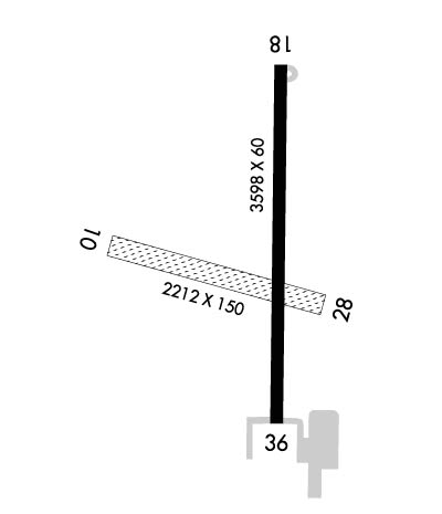
Runway Identification: 10/28Length: 2212 ft
Width: 150 ft
Surface: GRASS-GOOD CONDITION
Edge lights: Treatment: NONE
| | Runway: 10 | | Runway: 28 |
| Mag heading: | 99° | Mag heading: | 279° |
| Rwy Slope: | .29% Up | Rwy Slope: | -.29% Down |
| Approach: | | Approach: | |
| Pattern: | Left Traffic | Pattern: | Left Traffic |
| Markings: | NONE | Markings: | NONE |
| Marking Condition: | FAIR | Marking Condition: | FAIR |
| Arresting Dev: | | Arresting Dev: | |
| Lat & Long: | N3709.5 W09805.1 | Lat. & Long.: | N3709.4 W09804.6 |
| Elev: | 1329.6 ft. MSL | Elev: | 1336.0 ft. MSL |
| TCH: | | TCH: | |
| Visual Glide Path: | | Visual Glide Path: | |
| Displaced Threshold: | No | Displaced Threshold: | No |
| Touchdown Zone: | YES | Touchdown Zone: | YES |
| Touchdown Elev.: | 1340.6 feet | Touchdown Elev.: | 1340.6 feet |
| Visual Glide Slope: | | Visual Glide Slope: | |
| RVR Equipment: | | RVR Equipment: | |
| RVV Equipment: | NO | RVV Equipment: | NO |
| Approach Lights: | | Approach Lights: | |
| REIL: | NO | REIL: | NO |
| Centerline Lights: | NO | Centerline Lights: | NO |
| Touchdown lights: | NO | Touchdown lights: | NO |
| Runway Category: | Runway with a Visual Approach | Runway Category: | Runway with a Visual Approach |
| Declared Distances: | | Declared Distances: | |
| Obstructions: | TREES | Obstructions: | ROAD |
| Marked: | NOT Marked/Lighted | Marked: | NOT Marked/Lighted |
| Clearance slope: | 5:1 | Clearance slope: | 23:1 |
| Obstruction height: | 68 feet AGL | Obstruction height: | 13 feet AGL |
| Dist. from runway: | 315 feet | Dist. from runway: | 300 feet |
| Centerline offset: | | Centerline offset: | |
| Comments: | | Comments: | |
Runway Identification: 18/36Length: 5002 ft
Width: 75 ft
Surface: CONCRETE
Edge lights: Low IntensityTreatment: NONE
Weight: PCN 11 /R/C/X/U
| | Runway: 18 | | Runway: 36 |
| Mag heading: | 175° | Mag heading: | 355° |
| Rwy Slope: | -.16% Down | Rwy Slope: | .16% Up |
| Approach: | | Approach: | |
| Pattern: | Left Traffic | Pattern: | Left Traffic |
| Markings: | NONPRECISION INSTRUMENT | Markings: | NONPRECISION INSTRUMENT |
| Marking Condition: | FAIR | Marking Condition: | FAIR |
| Arresting Dev: | | Arresting Dev: | |
| Lat & Long: | N3710.1 W09804.7 | Lat. & Long.: | N3709.2 W09804.7 |
| Elev: | 1343.0 ft. MSL | Elev: | 1335.2 ft. MSL |
| TCH: | 44 ft. AGL | TCH: | 46 ft. AGL |
| Visual Glide Path: | 3.00 degrees | Visual Glide Path: | 3.00 degrees |
| Displaced Threshold: | No | Displaced Threshold: | No |
| Touchdown Zone: | YES | Touchdown Zone: | YES |
| Touchdown Elev.: | 1343.1 feet | Touchdown Elev.: | 1341.3 feet |
| Visual Glide Slope: | 2-Light PAPI on LEFT side of Runway | Visual Glide Slope: | 2-Light PAPI on LEFT side of Runway |
| RVR Equipment: | | RVR Equipment: | |
| RVV Equipment: | NO | RVV Equipment: | NO |
| Approach Lights: | | Approach Lights: | |
| REIL: | NO | REIL: | NO |
| Centerline Lights: | NO | Centerline Lights: | NO |
| Touchdown lights: | NO | Touchdown lights: | NO |
| Runway Category: | Runway with a Non-precision Approach having visibility minimums greater than 3/4 mile | Runway Category: | Runway with a Non-precision Approach having visibility minimums greater than 3/4 mile |
| Declared Distances: | | Declared Distances: | |
| Obstructions: | | Obstructions: | TREE |
| Marked: | | Marked: | NOT Marked/Lighted |
| Clearance slope: | 34:1 | Clearance slope: | 20:1 |
| Obstruction height: | | Obstruction height: | 34 feet AGL |
| Dist. from runway: | | Dist. from runway: | 894 feet |
| Centerline offset: | | Centerline offset: | |
| Comments: | | Comments: | |

