Current Weather/Notams (Metars, TAFs, Notams, NWS Forecast, PIREPS, and nearby weather)
Customs Information Send updates to Support@FltPlan.com
Customs Not Available
Database effective 04/18/2024
Airport Diagram might not be current.
|
| Facility Name: | TRI-STATE STEUBEN COUNTY |
| City Name: | ANGOLA |
| County: | STEUBEN |
| State abbrev: | IN |
| State Name: | INDIANA |
| | |
| Ownership: | PUBLICLY OWNED |
| Use: | OPEN TO THE PUBLIC |
| Owner's Name: | STEUBEN CO BOAC |
| Address: | 5220 W. U.S. 20 |
| | ANGOLA, IN 46703-9680 |
| Owner's Phone: | (260) 665-7111 |
| | |
| Manager's Name: | AARON PAYONK |
| Address: | 5220 W. U.S. 20 |
| | ANGOLA, IN 46703-9680 |
| Phone: | 260-316-3711 |
| | |
| FAA Region: | GREAT LAKES |
| FAA Field Office: | CHI |
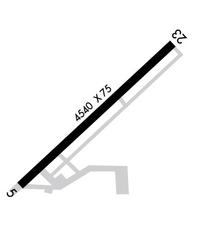
Runway Identifications
Runway Identification: 05/23Length: 4540 ft
Width: 75 ft
Surface: ASPHALT
Edge lights: Medium IntensityTreatment: GROOVED
| | Runway: 05 | | Runway: 23 |
| Mag heading: | 52° | Mag heading: | 232° |
| Rwy Slope: | .19% Up | Rwy Slope: | -.19% Down |
| Approach: | | Approach: | |
| Pattern: | Left Traffic | Pattern: | Left Traffic |
| Markings: | NONPRECISION INSTRUMENT | Markings: | NONPRECISION INSTRUMENT |
| Marking Condition: | GOOD | Marking Condition: | FAIR |
| Arresting Dev: | | Arresting Dev: | |
| Lat & Long: | N4138.1 W08505.4 | Lat. & Long.: | N4138.6 W08504.6 |
| Elev: | 986.1 ft. MSL | Elev: | 994.8 ft. MSL |
| TCH: | 38 ft. AGL | TCH: | 49 ft. AGL |
| Visual Glide Path: | 3.00 degrees | Visual Glide Path: | 4.00 degrees |
| Displaced Threshold: | 540 feet | Displaced Threshold: | No |
| Touchdown Zone: | YES | Touchdown Zone: | YES |
| Touchdown Elev.: | 990.1 feet | Touchdown Elev.: | 995.0 feet |
| Visual Glide Slope: | 2-Light PAPI on LEFT side of Runway | Visual Glide Slope: | 2-Light PAPI on LEFT side of Runway |
| RVR Equipment: | | RVR Equipment: | |
| RVV Equipment: | NO | RVV Equipment: | NO |
| Approach Lights: | | Approach Lights: | |
| REIL: | YES | REIL: | YES |
| Centerline Lights: | NO | Centerline Lights: | NO |
| Touchdown lights: | NO | Touchdown lights: | NO |
| Runway Category: | Runway with a Non-precision Approach having visibility minimums greater than 3/4 mile | Runway Category: | Runway with a Non-precision Approach having visibility minimums greater than 3/4 mile |
| Declared Distances: | TORA:4540' TODA:4540' ASDA:4540' LDA:4000' | Declared Distances: | TORA:4000' TODA:4000' ASDA:4000' LDA:4000' |
| Obstructions: | ROAD | Obstructions: | TREES |
| Marked: | NOT Marked/Lighted | Marked: | NOT Marked/Lighted |
| Clearance slope: | APCH SLOPE 34:1 FM DTHR. | Clearance slope: | 9:1 |
| Obstruction height: | 15 feet AGL | Obstruction height: | 73 feet AGL |
| Dist. from runway: | 200 feet | Dist. from runway: | 860 feet |
| Centerline offset: | 205 right of centerline | Centerline offset: | 280 feet right of centerline |
| Comments: | 15 FT ROAD 200 FT FM RWY END 205 FT R. | Comments: | |

