Current Weather/Notams (Metars, TAFs, Notams, NWS Forecast, PIREPS, and nearby weather)
Customs Information Send updates to Support@FltPlan.com
Customs Not Available
Database effective 05/16/2024
Airport Diagram might not be current. Facility Name: AMES MUNI City Name: AMES County: STORY State abbrev: IA State Name: IOWA Ownership: PUBLICLY OWNED Use: OPEN TO THE PUBLIC Owner's Name: CITY OF AMES Address: 515 CLARK AVE AMES, IA 50010 Owner's Phone: 515-239-5160 Manager's Name: DAMION PREGITZER Address: 515 CLARK AVE AMES, IA 50010 Phone: 515-239-5275 FAA Region: CENTRAL FAA Field Office: NONE
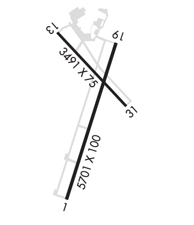
Runway Identifications Help
Runway Identification: 01/19 Length: 5701 ftWidth: 100 ftSurface: ASPHALT-FAIR CONDITIONEdge lights: High Intensity Treatment: NONEWeight: PCN 32 /R/C/W/U Runway: 01 Runway: 19 Mag heading: 14° Mag heading: 194° Rwy Slope: -.64% Down Rwy Slope: .64% Up Approach: ILS/DME Approach: Pattern: Right Traffic Pattern: Left Traffic Markings: PRECISION INSTRUMENT Markings: NONPRECISION INSTRUMENT Marking Condition: GOOD Marking Condition: GOOD Arresting Dev: Arresting Dev: Lat & Long: N4159.0 W09337.5 Lat. & Long.: N4159.9 W09337.1 Elev: 955.6 ft. MSL Elev: 919.0 ft. MSL TCH: TCH: 41 ft. AGL Visual Glide Path: Visual Glide Path: 4.00 degrees Displaced Threshold: No Displaced Threshold: No Touchdown Zone: YES Touchdown Zone: YES Touchdown Elev.: 955.6 feet Touchdown Elev.: 937.4 feet Visual Glide Slope: Visual Glide Slope: 4-BOX VASI ON LEFT SIDE OF RUNWAY RVR Equipment: RVR Equipment: RVV Equipment: NO RVV Equipment: NO Approach Lights: MALSR - 1,400 foot medium intensity approach lighting system with runway alignment indicator lights Approach Lights: REIL: NO REIL: NO Centerline Lights: NO Centerline Lights: NO Touchdown lights: NO Touchdown lights: NO Runway Category: Precision Instrument Runway Runway Category: Runway with a Non-precision Approach having visibility minimums greater than 3/4 mile Declared Distances: Declared Distances: Obstructions: TREE Obstructions: TREE Marked: NOT Marked/Lighted Marked: NOT Marked/Lighted Clearance slope: 27:1 Clearance slope: 25:1 Obstruction height: 78 feet AGL Obstruction height: 87 feet AGL Dist. from runway: 2380 feet Dist. from runway: 2400 feet Centerline offset: 350 left of centerline Centerline offset: 345 feet left of centerline Comments: Comments:
Runway Identification: 13/31 Length: 3491 ftWidth: 75 ftSurface: CONCRETE-FAIR CONDITIONEdge lights: Medium Intensity Treatment: NONEWeight: PCN 10 /R/D/W/U Runway: 13 Runway: 31 Mag heading: 133° Mag heading: 313° Rwy Slope: -.16% Down Rwy Slope: .16% Up Approach: Approach: Pattern: Right Traffic Pattern: Left Traffic Markings: NONPRECISION INSTRUMENT Markings: NONPRECISION INSTRUMENT Marking Condition: GOOD Marking Condition: GOOD Arresting Dev: Arresting Dev: Lat & Long: N4159.9 W09337.6 Lat. & Long.: N4159.5 W09337.0 Elev: 925.9 ft. MSL Elev: 920.2 ft. MSL TCH: 43 ft. AGL TCH: 36 ft. AGL Visual Glide Path: 3.00 degrees Visual Glide Path: 3.00 degrees Displaced Threshold: No Displaced Threshold: No Touchdown Zone: YES Touchdown Zone: YES Touchdown Elev.: 929.3 feet Touchdown Elev.: 929.3 feet Visual Glide Slope: 4-BOX VASI ON LEFT SIDE OF RUNWAY Visual Glide Slope: 4-BOX VASI ON LEFT SIDE OF RUNWAY RVR Equipment: RVR Equipment: RVV Equipment: NO RVV Equipment: NO Approach Lights: Approach Lights: REIL: NO REIL: NO Centerline Lights: NO Centerline Lights: NO Touchdown lights: NO Touchdown lights: NO Runway Category: Runway with a Non-precision Approach having visibility minimums greater than 3/4 mile Runway Category: Runway with a Non-precision Approach having visibility minimums greater than 3/4 mile Declared Distances: Declared Distances: Obstructions: TREE Obstructions: TREE Marked: NOT Marked/Lighted Marked: NOT Marked/Lighted Clearance slope: 7:1 Clearance slope: 16:1 Obstruction height: 16 feet AGL Obstruction height: 50 feet AGL Dist. from runway: 320 feet Dist. from runway: 1011 feet Centerline offset: 164 left of centerline Centerline offset: 70 feet right of centerline Comments: 32 FT TREE 124 FT FM RWY END AND 158 FT R ON APCH; CLNC SLOPE 1:1 Comments: