Current Weather/Notams (Metars, TAFs, Notams, NWS Forecast, PIREPS, and nearby weather)
Customs Information Send updates to Support@FltPlan.com
Customs Not Available
Database effective 04/18/2024
Airport Diagram might not be current.
|
| Facility Name: | GRATIOT COMMUNITY |
| City Name: | ALMA |
| County: | GRATIOT |
| State abbrev: | MI |
| State Name: | MICHIGAN |
| | |
| Ownership: | PUBLICLY OWNED |
| Use: | OPEN TO THE PUBLIC |
| Owner's Name: | CITY OF ALMA/CO OF GRATIOT |
| Address: | 525 E SUPERIOR ST, PO BOX 278 |
| | ALMA, MI 48801 |
| Owner's Phone: | 989-463-8336 |
| | |
| Manager's Name: | SCOTT MCDONALD |
| Address: | 3999 W SEAMAN RD |
| | ALMA, MI 48801-9232 |
| Phone: | 989-463-5500 |
| | |
| FAA Region: | GREAT LAKES |
| FAA Field Office: | DET |
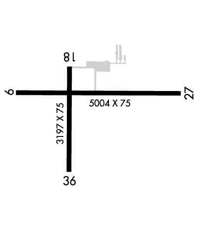
Runway Identifications
Runway Identification: 09/27Length: 5004 ft
Width: 75 ft
Surface: ASPHALT-GOOD CONDITION
Edge lights: Medium IntensityTreatment: GROOVED
| | Runway: 09 | | Runway: 27 |
| Mag heading: | 95° | Mag heading: | 275° |
| Rwy Slope: | .05% Up | Rwy Slope: | -.05% Down |
| Approach: | SDF | Approach: | |
| Pattern: | Left Traffic | Pattern: | Left Traffic |
| Markings: | NONPRECISION INSTRUMENT | Markings: | NONPRECISION INSTRUMENT |
| Marking Condition: | FAIR | Marking Condition: | FAIR |
| Arresting Dev: | | Arresting Dev: | |
| Lat & Long: | N4319.4 W08441.8 | Lat. & Long.: | N4319.4 W08440.6 |
| Elev: | 750.5 ft. MSL | Elev: | 753.2 ft. MSL |
| TCH: | 40 ft. AGL | TCH: | 40 ft. AGL |
| Visual Glide Path: | 3.00 degrees | Visual Glide Path: | 3.00 degrees |
| Displaced Threshold: | No | Displaced Threshold: | No |
| Touchdown Zone: | YES | Touchdown Zone: | YES |
| Touchdown Elev.: | 753.5 feet | Touchdown Elev.: | 753.5 feet |
| Visual Glide Slope: | 4-Light PAPI on LEFT side of Runway | Visual Glide Slope: | 4-Light PAPI on LEFT side of Runway |
| RVR Equipment: | | RVR Equipment: | |
| RVV Equipment: | NO | RVV Equipment: | NO |
| Approach Lights: | | Approach Lights: | |
| REIL: | YES | REIL: | YES |
| Centerline Lights: | NO | Centerline Lights: | NO |
| Touchdown lights: | NO | Touchdown lights: | NO |
| Runway Category: | Runway with a Non-precision Approach having visibility minimums greater than 3/4 mile | Runway Category: | Runway with a Non-precision Approach having visibility minimums greater than 3/4 mile |
| Declared Distances: | | Declared Distances: | |
| Obstructions: | TREE | Obstructions: | |
| Marked: | NOT Marked/Lighted | Marked: | |
| Clearance slope: | 26:1 | Clearance slope: | 34:1 |
| Obstruction height: | 79 feet AGL | Obstruction height: | |
| Dist. from runway: | 2307 feet | Dist. from runway: | |
| Centerline offset: | 266 left of centerline | Centerline offset: | |
| Comments: | | Comments: | |
Runway Identification: 18/36Length: 3198 ft
Width: 75 ft
Surface: ASPHALT-GOOD CONDITION
Edge lights: Medium IntensityTreatment: GROOVED
| | Runway: 18 | | Runway: 36 |
| Mag heading: | 185° | Mag heading: | 5° |
| Rwy Slope: | .03% Up | Rwy Slope: | -.03% Down |
| Approach: | | Approach: | |
| Pattern: | Left Traffic | Pattern: | Left Traffic |
| Markings: | NONPRECISION INSTRUMENT | Markings: | NONPRECISION INSTRUMENT |
| Marking Condition: | FAIR | Marking Condition: | FAIR |
| Arresting Dev: | | Arresting Dev: | |
| Lat & Long: | N4319.5 W08441.4 | Lat. & Long.: | N4319.0 W08441.4 |
| Elev: | 753.2 ft. MSL | Elev: | 754.0 ft. MSL |
| TCH: | | TCH: | |
| Visual Glide Path: | | Visual Glide Path: | |
| Displaced Threshold: | No | Displaced Threshold: | No |
| Touchdown Zone: | YES | Touchdown Zone: | YES |
| Touchdown Elev.: | 753.9 feet | Touchdown Elev.: | 754.1 feet |
| Visual Glide Slope: | | Visual Glide Slope: | |
| RVR Equipment: | | RVR Equipment: | |
| RVV Equipment: | NO | RVV Equipment: | NO |
| Approach Lights: | | Approach Lights: | |
| REIL: | NO | REIL: | NO |
| Centerline Lights: | NO | Centerline Lights: | NO |
| Touchdown lights: | NO | Touchdown lights: | NO |
| Runway Category: | Runway with a Non-precision Approach having visibility minimums greater than 3/4 mile | Runway Category: | Runway with a Visual Approach |
| Declared Distances: | | Declared Distances: | |
| Obstructions: | TREE | Obstructions: | |
| Marked: | NOT Marked/Lighted | Marked: | |
| Clearance slope: | 16:1 | Clearance slope: | 20:1 |
| Obstruction height: | 56 feet AGL | Obstruction height: | |
| Dist. from runway: | 1119 feet | Dist. from runway: | |
| Centerline offset: | 383 left of centerline | Centerline offset: | |
| Comments: | | Comments: | |

