Land at any FBO in our growing worldwide network and you'll receive a warm, friendly Signature greeting. Consistent, exceptional service. Line support that's expert, safe and ready on the ramp. Clean, comfortable, well-furnished facilities. Service professionals who go the extra mile for your passengers and crew. Competitive pricing in every market.
These numbers are Advisory and are not limits. The Airport Manager should have more accurate Weight Limits
Approach Charts
Current Weather/Notams (Metars, TAFs, Notams, NWS Forecast, PIREPS, and nearby weather)
Customs Information Send updates to Support@FltPlan.com
Phone 806-335-3533 Fax 806-335-3627
Comments 2 hrs advance notice required 4 hrs after hours. Business hrs 0830-1700 Monday-Friday. *Maximum passengers per flight: 20 *Call prior to 1630 on preceding weekday. *Weekend arrivals call prior to 1630 on preceeding Friday
Sunrise / Sunset times for RICK HUSBAND AMARILLO INTL
Date
Sunrise
Sunset
04/24/24 Wednesday
7:03
20:28
04/25/24 Thursday
7:01
20:28
04/26/24 Friday
7:00
20:29
04/27/24 Saturday
6:59
20:30
04/28/24 Sunday
6:58
20:31
04/29/24 Monday
6:57
20:32
04/30/24 Tuesday
6:56
20:33
05/01/24 Wednesday
6:55
20:33
05/02/24 Thursday
6:54
20:34
05/03/24 Friday
6:53
20:35
05/04/24 Saturday
6:52
20:36
05/05/24 Sunday
6:51
20:37
05/06/24 Monday
6:50
20:37
05/07/24 Tuesday
6:49
20:38
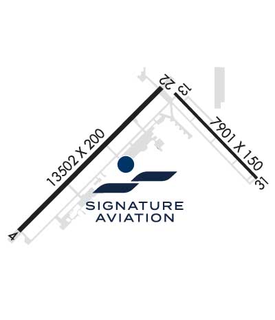
Airport Facilities
Airport Attendance Schedule
CONTINUOUS
Airport Status
OPERATIONAL (This Status can change at any time - please check NOTAMS)
Airport Lighting Schedule
WHEN ATCT CLSD, TO INCR INTST AND ACTVT MALSR RWYS 04 & 22; REIL RWY 13; HIRL RWYS 04/22, 13/31; ALL TWYS - CTAF.
Airport Storage Available
Tie Downs, Hanger
Extra Services Available
Air Freight, Air Ambulance, Avionics, Cargo Handling, Charter, Flight Instruction, Aircraft Rental, Aircraft Sales
Wind Indicator
YES - (lighted)
Control Tower
YES
CTAF Frequency
118.300
Unicom Frequency
122.950
Rotating Beacon Color
WG
Segmented Circle
YES
Landing Fee
YES
Airport Inspection Data
Airport Inspected
FEDERAL - performed by FAA AIRPORTS FIELD PERSONNEL
Inspection Date
08/18/2022
Airport Services
Type of Fuel Available
Grade 100LL, JET A-1 (icing inhibitor, freeze point -50C)
Airframe Repair Service
MAJOR
Power Plant Repair Service
MAJOR
Geographic Data
Latitude
N3513.2
Longitude
W10142.4 (ESTIMATED)
Arpt Elevation
3606ft (SURVEYED)
Magnetic Variation
08E
7 miles E
of AMARILLO
Traffic Pattern Altitude
895; TPA: 895 FT AGL PROP ACFT, 1395 FT AGL TURBOJET ACFT, 1895 FT AGL OVERHEAD .
Sectional Chart
DALLAS-FT WORTH
Aircraft Data
Operations (Reported)
Yearly
Avg. Daily
General Aviation Transient
11738
32
General Aviation Local
4248
12
Air Taxi
6327
17
Commerical
8078
22
Commuter
0
0
Military
12757
35
Aircraft based on Field
General Aviation Singles
9
General Aviation Multi
11
Jet Aircraft
9
General Aviation Helicopters
0
Military Aircraft
0
Gliders
0
Ultralights
0
FAA Services
FSS on field
NO
FSS tie-in
FORT WORTH
FSS Phone
1-800-WX-BRIEF
Who issues Notams
AMA
Notam D service at airport
YES
ARTCC Name
ALBUQUERQUE
Federal Status
Airport Certification
AIRPORT RECEIVING SCHEDULED AIR CARRIER SERVICE FROM CARRIERS CERTIFICATED BY THE CIVIL AERONAUTICS BOARD; INDEX C EQUIP AVBL UPON REQ.
Aircraft Rescue & Firefighting Index
AIRPORT HAS A CERTIFICATE UNDER CFR PART 139
Airport of Entry
No
Custom Landing Rights
YES
Joint Civil/Military
No
Military Landing rights
YES
Federal Agreements
NATIONAL PLAN OF INTEGRATED AIRPORT SYSTEMS (NPIAS)
GRANT AGREEMENTS UNDER FAAP/ADAP/AIP
SURPLUS PROPERTY AGREEMENT UNDER PUBLIC LAW 289
ASSURANCES PURSUANT TO TITLE VI, CIVIL RIGHTS ACT OF 1964
AGREEMENT UNDER DLAND OR DCLA HAS EXPIRED.
Remarks
TILTROTOR ACFT ACTIVITY INVOF ARPT.
LDG FEE.
FOR CD IF UNA TO CTC ON FSS FREQ, CTC ALBUQUERQUE ARTCC AT 505-856-4561.
RWY 04/2 2 CENTER 130 FT GROOVED FULL LENGTH.
RWY 04/2 2 RWY 04/22 NSTD HIRL DUE TO SPACING. HIRL 50 FT FM RWY EDGE, NSTD DSTC FM CNTRLN - PAVEMENT OUTSIDE RWY EDGE STRIPES MAY NOT BE FULL STRENGTH AND DEPTH PERCEPTION PROBLEMS MAY EXIST DURING PERIODS OF DARKNESS.
Airport Communications & Frequencies:
ATIS Frequencies: Hours(local) of Operation: CONTINUOUS
118.85
350.3
AMARILLO Tower Frequencies: Hours(local) of operation: 0600-0000
118.3
257.9
AMARILLO Ground Frequencies:
121.9
348.6
Clearance Delivery Frequencies:
121.65
239.275
Emergency Frequencies:
121.5
243.0
CTAF Frequency:
118.300
Unicom Frequency:
122.950
Remarks
APCH/DEP SVC PRVDD BY ALBUQUERQUE ARTCC (ZAB) ON FREQS 127.85/285.475 (AMARILLO RCAG) WHEN AMARILLO APCH CTL (AMA) CLSD.
AMARILLO Primary Approach Frequencies: Hours(local) of operation: 0600-0000
119.5
307.0
ALBUQUERQUE ARTCC Part-time Approach Frequencies: Hours(local) of operation: 0000-0600
121.15
307.9
AMARILLO Primary Departure Frequencies: Hours(local) of operation: 0600-0000
119.5
307.0
ALBUQUERQUE ARTCC Part-time Departure Frequencies: Hours(local) of operation: 0000-0600