Current Weather/Notams (Metars, TAFs, Notams, NWS Forecast, PIREPS, and nearby weather)
Customs Information Send updates to Support@FltPlan.com
Phone 330-499-5070
Fax N/A
Comments 1 hr advance notice required. Business hrs 0800-1630 Monday-Friday.
Database effective 04/18/2024
Airport Diagram might not be current.
|
| Facility Name: | AKRON FULTON INTL |
| City Name: | AKRON |
| County: | SUMMIT |
| State abbrev: | OH |
| State Name: | OHIO |
| | |
| Ownership: | PUBLICLY OWNED |
| Use: | OPEN TO THE PUBLIC |
| Owner's Name: | CITY OF AKRON |
| Address: | 166 S HIGH ST RM 701 |
| | AKRON, OH 44308-1627 |
| Owner's Phone: | 330-375-2699 |
| | |
| Manager's Name: | ANTHONY PLUCINSKI; TONYP@SUMMITAIRPORTSERVICES.COM. |
| Address: | 1600 TRIPLETT BLVD |
| | AKRON, OH 44306-3308 |
| Phone: | 330-733-4760 |
| | |
| FAA Region: | GREAT LAKES |
| FAA Field Office: | DET |
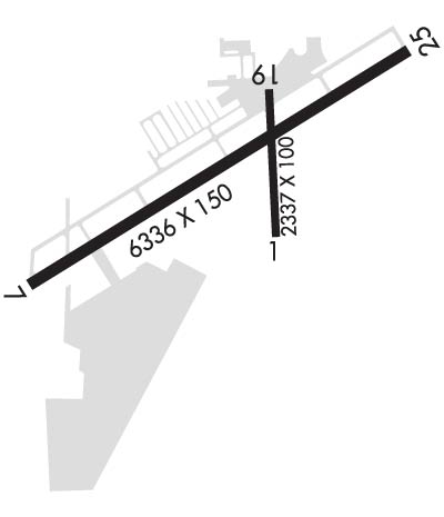
Runway Identifications
Runway Identification: 07/25Length: 6336 ft
Width: 150 ft
Surface: ASPHALT-GOOD CONDITION
Edge lights: Medium IntensityTreatment: NONE
| | Runway: 07 | | Runway: 25 |
| Mag heading: | 69° | Mag heading: | 249° |
| Rwy Slope: | -.10% Down | Rwy Slope: | .10% Up |
| Approach: | | Approach: | LOC/DME |
| Pattern: | Left Traffic | Pattern: | Left Traffic |
| Markings: | NONPRECISION INSTRUMENT | Markings: | NONPRECISION INSTRUMENT |
| Marking Condition: | GOOD | Marking Condition: | GOOD |
| Arresting Dev: | | Arresting Dev: | |
| Lat & Long: | N4102.0 W08128.7 | Lat. & Long.: | N4102.5 W08127.5 |
| Elev: | 1067.3 ft. MSL | Elev: | 1060.8 ft. MSL |
| TCH: | 45 ft. AGL | TCH: | 45 ft. AGL |
| Visual Glide Path: | 3.60 degrees | Visual Glide Path: | 4.00 degrees |
| Displaced Threshold: | 760 feet | Displaced Threshold: | 262 feet |
| Touchdown Zone: | YES | Touchdown Zone: | YES |
| Touchdown Elev.: | 1055.0 feet | Touchdown Elev.: | 1058.7 feet |
| Visual Glide Slope: | 4-Light PAPI on LEFT side of Runway | Visual Glide Slope: | 4-Light PAPI on LEFT side of Runway |
| RVR Equipment: | | RVR Equipment: | |
| RVV Equipment: | NO | RVV Equipment: | NO |
| Approach Lights: | | Approach Lights: | |
| REIL: | YES | REIL: | YES |
| Centerline Lights: | NO | Centerline Lights: | NO |
| Touchdown lights: | NO | Touchdown lights: | NO |
| Runway Category: | Runway with a Visual Approach | Runway Category: | Runway with a Non-precision Approach having visibility minimums greater than 3/4 mile |
| Declared Distances: | | Declared Distances: | |
| Obstructions: | RR | Obstructions: | TREE |
| Marked: | NOT Marked/Lighted | Marked: | LIGHTED |
| Clearance slope: | 1:1; APCH RATIO 17:1 TO DSPLCD THR DUE TO +124 FT TREE 2129 FT FM THR 61 FT L. | Clearance slope: | 15:1; APCH RATIO 12:1 TO DSPLCD THR DUE TO +108 FT TREE 1310 FT FM THR 422 FT RIGHT. |
| Obstruction height: | 23 feet AGL | Obstruction height: | 106 feet AGL |
| Dist. from runway: | 201 feet | Dist. from runway: | 1836 feet |
| Centerline offset: | 140 right of centerline | Centerline offset: | 441 feet left of centerline |
| Comments: | 23 FT RAILROAD 0-200 FT FM, 155 FT L TO 140 FT RIGHT. | Comments: | |

