Current Weather/Notams (Metars, TAFs, Notams, NWS Forecast, PIREPS, and nearby weather)
Customs Information Send updates to Support@FltPlan.com
Customs Not Available
Database effective 04/18/2024
Airport Diagram might not be current.
|
| Facility Name: | WAKEFIELD MUNI |
| City Name: | WAKEFIELD |
| County: | SUSSEX |
| State abbrev: | VA |
| State Name: | VIRGINIA |
| | |
| Ownership: | PUBLICLY OWNED |
| Use: | OPEN TO THE PUBLIC |
| Owner's Name: | TOWN OF WAKEFIELD |
| Address: | P O BOX 550 |
| | WAKEFIELD, VA 23888 |
| Owner's Phone: | 757-899-2030 |
| | |
| Manager's Name: | BRIAN LAINE |
| Address: | P.O. BOX 550 |
| | WAKEFIELD, VA 23888 |
| Phone: | 757-899-0096 |
| | |
| FAA Region: | EASTERN |
| FAA Field Office: | DCA |
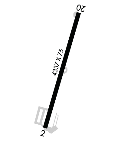
Runway Identifications
Runway Identification: 02/20Length: 4337 ft
Width: 75 ft
Surface: ASPHALT-FAIR CONDITION
Edge lights: Medium IntensityTreatment: NONE
| | Runway: 02 | | Runway: 20 |
| Mag heading: | 28° | Mag heading: | 208° |
| Rwy Slope: | .09% Up | Rwy Slope: | -.09% Down |
| Approach: | | Approach: | |
| Pattern: | Left Traffic | Pattern: | Left Traffic |
| Markings: | NONPRECISION INSTRUMENT | Markings: | NONPRECISION INSTRUMENT |
| Marking Condition: | POOR; RWY 2 MRKGS CVRD WITH ALGAE. | Marking Condition: | POOR; RWY 20 MRKGS CVRD WITH ALGAE. |
| Arresting Dev: | | Arresting Dev: | |
| Lat & Long: | N3658.9 W07700.2 | Lat. & Long.: | N3659.6 W07659.9 |
| Elev: | 107.4 ft. MSL | Elev: | 111.4 ft. MSL |
| TCH: | | TCH: | |
| Visual Glide Path: | | Visual Glide Path: | |
| Displaced Threshold: | 298 feet | Displaced Threshold: | 471 feet |
| Touchdown Zone: | YES | Touchdown Zone: | YES |
| Touchdown Elev.: | 108.5 feet | Touchdown Elev.: | 109.9 feet |
| Visual Glide Slope: | | Visual Glide Slope: | |
| RVR Equipment: | | RVR Equipment: | |
| RVV Equipment: | NO | RVV Equipment: | NO |
| Approach Lights: | | Approach Lights: | |
| REIL: | NO | REIL: | NO |
| Centerline Lights: | NO | Centerline Lights: | NO |
| Touchdown lights: | NO | Touchdown lights: | NO |
| Runway Category: | Runway with a Visual Approach | Runway Category: | Runway with a Visual Approach |
| Declared Distances: | | Declared Distances: | |
| Obstructions: | TREES | Obstructions: | TREES |
| Marked: | NOT Marked/Lighted | Marked: | NOT Marked/Lighted |
| Clearance slope: | CTLNG OBSTN EXCEEDS A 45 DEG SLP, CLNC SLP TO DSPLCD THLD 8:1. | Clearance slope: | 15:1; CLNC SLP TO DSPLCD THLD 22:1. |
| Obstruction height: | 28 feet AGL | Obstruction height: | 62 feet AGL |
| Dist. from runway: | 201 feet | Dist. from runway: | 1154 feet |
| Centerline offset: | 52 left of centerline | Centerline offset: | 34 feet right of centerline |
| Comments: | RD +15' 70' FM THR CROSSING END. | Comments: | ROAD +15 FT 70 FT FM RY END. |

