Approach Charts
| FltPlan does not have IFR approach charts available for KAK8. |
Current Weather/Notams (Metars, TAFs, Notams, NWS Forecast, PIREPS, and nearby weather)
Customs Information Send updates to Support@FltPlan.com
Customs Not Available
Database effective 05/16/2024
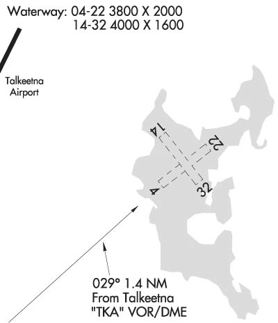
Airport Diagram might not be current.
|
| Facility Name: | CHRISTIANSEN LAKE |
| City Name: | TALKEETNA |
| County: | MATANUSKA-SUSITNA |
| State abbrev: | AK |
| State Name: | ALASKA |
| | |
| Ownership: | PRIVATELY OWNED |
| Use: | OPEN TO THE PUBLIC |
| Owner's Name: | DON LEE |
| Address: | P.O. BOX 139 |
| | TALKEETNA, AK 99676 |
| Owner's Phone: | 907-733-4500 |
| | |
| Manager's Name: | DON LEE |
| Address: | P.O. BOX 139 |
| | TALKEETNA, AK 99676 |
| Phone: | 907-733-4500 |
| | |
| FAA Region: | ALASKA |
| FAA Field Office: | NONE |
Runway Identifications
Runway Identification: 04W/22WLength: 3800 ft
Width: 2000 ft
Surface: WATER
Edge lights: Treatment: NONE
| | Runway: 04W | | Runway: 22W |
| Mag heading: | N/A | Mag heading: | N/A |
| Approach: | | Approach: | |
| Pattern: | Left Traffic | Pattern: | Left Traffic |
| Markings: | | Markings: | |
| Marking Condition: | | Marking Condition: | |
| Arresting Dev: | | Arresting Dev: | |
| Lat & Long: | | Lat. & Long.: | |
| Elev: | N/A | Elev: | N/A |
| TCH: | | TCH: | |
| Visual Glide Path: | | Visual Glide Path: | |
| Displaced Threshold: | No | Displaced Threshold: | No |
| Touchdown Zone: | NO | Touchdown Zone: | NO |
| Touchdown Elev.: | | Touchdown Elev.: | |
| Visual Glide Slope: | | Visual Glide Slope: | |
| RVR Equipment: | | RVR Equipment: | |
| RVV Equipment: | NO | RVV Equipment: | NO |
| Approach Lights: | | Approach Lights: | |
| REIL: | NO | REIL: | NO |
| Centerline Lights: | NO | Centerline Lights: | NO |
| Touchdown lights: | NO | Touchdown lights: | NO |
| Runway Category: | | Runway Category: | |
| Declared Distances: | | Declared Distances: | |
Runway Identification: 14W/32WLength: 4000 ft
Width: 1600 ft
Surface: WATER
Edge lights: Treatment: NONE
| | Runway: 14W | | Runway: 32W |
| Mag heading: | N/A | Mag heading: | N/A |
| Approach: | | Approach: | |
| Pattern: | Left Traffic | Pattern: | Left Traffic |
| Markings: | | Markings: | |
| Marking Condition: | | Marking Condition: | |
| Arresting Dev: | | Arresting Dev: | |
| Lat & Long: | | Lat. & Long.: | |
| Elev: | N/A | Elev: | N/A |
| TCH: | | TCH: | |
| Visual Glide Path: | | Visual Glide Path: | |
| Displaced Threshold: | No | Displaced Threshold: | No |
| Touchdown Zone: | NO | Touchdown Zone: | NO |
| Touchdown Elev.: | | Touchdown Elev.: | |
| Visual Glide Slope: | | Visual Glide Slope: | |
| RVR Equipment: | | RVR Equipment: | |
| RVV Equipment: | NO | RVV Equipment: | NO |
| Approach Lights: | | Approach Lights: | |
| REIL: | NO | REIL: | NO |
| Centerline Lights: | NO | Centerline Lights: | NO |
| Touchdown lights: | NO | Touchdown lights: | NO |
| Runway Category: | | Runway Category: | |
| Declared Distances: | | Declared Distances: | |

