Click here for more info on on SMS!

KAJR

HABERSHAM COUNTY
CORNELIA
GA
Time Zone: Eastern
Lat: N 3430.0
Long: W 08333.4
Elev: 1448
Var: +06
Longest Runway: 5503
AWOS: 119.17
CTAF: 122.7

FBO & Flight Services info for KAJR

FBOs: Update your Fuel Prices
The airport has Jet A and 100LL gasoline. Card readers have now been installed so 100LL gasoline can be purchased outside of normal business hours. Jet A fuel is not self-service and can only be purchased during normal business hours. The airport also offers flight training as well as aircaft maintenance and repairs.
Ph: 706-839-0247
-
Freq: 122.7WebsiteE-Mail
                                  
Service
Jet
100LL
SAF
MoGas
Fuel Avail: PRIST PREMIXED
Full5.666.20    Last Update: 04/04/2024 13:15

Self  5.70    
Misc. Info: Address: 1112 AIRPORT RD,   CORNELIA, GA 30531-5601

AWOSPh: 706-778-3675
-
Freq: 119.17  
If you are an FBO, call 1-203-262-1700 to update your info or email: FltPlan.Advertising@garmin.com
Advertise your FBO on FltPlan.com

Runway & Approach Info for KAJR
Rwy
Length
Land Dist**
Approach*
  Rwy
Length
Land Dist**
Approach*
06
5503x100  4111'          
 
  
24
  5503x100  5503'          
 
 * only ILS, LOC, LDA, and SDF approaches to a specific runway are shown
** For any Declared Landing Distance Available, please see A/FD or Approach plates
Runway Weight Capability (lbs.) Help
Runway IDSingle WheelDouble WheelDouble Tandem WheelDual Double Wheel
06/2430,000N/AN/AN/A
These numbers are Advisory and are not limits.   The Airport Manager should have more accurate Weight Limits
Approach Charts
Approaches    
Current Weather/Notams
Customs Information Send updates to Support@FltPlan.com
Customs Not Available
Database effective 04/18/2024
Airport Diagram of KAJR
Airport Diagram might not be current.

Facility Name: HABERSHAM COUNTY
City Name: CORNELIA
County: HABERSHAM
State abbrev: GA
State Name: GEORGIA
   
Ownership: PUBLICLY OWNED
Use: OPEN TO THE PUBLIC
Owner's Name: HABERSHAM COUNTY
Address: 555 MONROE STREET, UNIT 20
 CLARKESVILLE, GA 30523
Owner's Phone: (706) 839-0200
  
Manager's Name: BILL HARDEN
Address: 1112 AIRPORT ROAD
 CORNELIA, GA 30531
Phone: 706-839-0247; ARPT PHONE NUMBER - (706) 778-0198.
   
FAA Region: SOUTHERN
FAA Field Office: ATL


Sunrise / Sunset times for HABERSHAM COUNTY

DateSunriseSunset
04/17/24 Wednesday6:5920:08
04/18/24 Thursday6:5820:09
04/19/24 Friday6:5720:10
04/20/24 Saturday6:5620:11
04/21/24 Sunday6:5520:12
04/22/24 Monday6:5320:12
04/23/24 Tuesday6:5220:13
04/24/24 Wednesday6:5120:14
04/25/24 Thursday6:5020:15
04/26/24 Friday6:4920:16
04/27/24 Saturday6:4820:16
04/28/24 Sunday6:4720:17
04/29/24 Monday6:4620:18
04/30/24 Tuesday6:4420:19

Airport Facilities

Airport Attendance Schedule7 Days A Week 0800-1800
Airport Status OPERATIONAL (This Status can change at any time - please check NOTAMS)
Airport Lighting ScheduleMIRL RWY 06/24 PRESET ON LOW INTST DUSK-2200; TO INCR INTST - CTAF. AFT 2200 ACTVT - CTAF.
Airport Storage AvailableTie Downs
Extra Services AvailableFlight Instruction, Aircraft Rental
Wind IndicatorYES - (lighted)
Control TowerNO
CTAF Frequency122.700
Unicom Frequency122.700
Rotating Beacon ColorWG
Segmented CircleYES
Landing FeeNO

Airport Inspection Data

Airport InspectedSTATE - performed by STATE AERONAUTICAL PERSONNEL
Inspection Date02/24/2023

Airport Services

Type of Fuel AvailableGrade 100LL, JET A
Airframe Repair ServiceMAJOR
Power Plant Repair ServiceMAJOR

Geographic Data

LatitudeN3430.0
LongitudeW08333.4 (ESTIMATED)
Arpt Elevation1447ft (SURVEYED)
Magnetic Variation06W
2 miles SWof CORNELIA
Traffic Pattern Altitude
Sectional ChartATLANTA

Aircraft Data

Operations (Reported)YearlyAvg. Daily
General Aviation Transient 1000027
General Aviation Local 1500041
Air Taxi 00
Commerical 00
Commuter 00
Military 00
Aircraft based on Field
General Aviation Singles 59
General Aviation Multi 4
Jet Aircraft 0
General Aviation Helicopters 1
Military Aircraft 0
Gliders 0
Ultralights 0

FAA Services

FSS on field NO
FSS tie-in MACON
FSS Phone 1-800-WX-BRIEF
Who issues Notams MCN
Notam D service at airport YES
ARTCC Name ATLANTA

Federal Status

Airport Certification
Aircraft Rescue & Firefighting IndexNone
Airport of EntryNo
Custom Landing RightsNo
Joint Civil/MilitaryNo
Military Landing rightsYES

Federal Agreements

NATIONAL PLAN OF INTEGRATED AIRPORT SYSTEMS (NPIAS)
GRANT AGREEMENTS UNDER FAAP/ADAP/AIP
ASSURANCES PURSUANT TO TITLE VI, CIVIL RIGHTS ACT OF 1964

Remarks

RWY 24 - CALM WIND RWY.
DEER & WILDLIFE ON OR INVOF ARPT.
FOR CD CTC ATLANTA ARTCC AT 770-210-7692.
RISING TRRN NW OF RWY 06/24 STARTING AT 120 FT FROM RCL.
TWY A BTN TWY D AND TWY C CLSD TO ACFT WINGSPAN MORE THAN 80 FT.
Airport Communications & Frequencies:
CTAF Frequency:
122.700
Unicom Frequency:
122.700
Remarks
  • APCH/DEP SVC PRVDD BY ATLANTA ARTCC ON FREQS 134.8/379.95 (MOUNT OGLETHORPE RCAG).
  • Runway Identifications
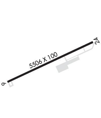
    Runway Identification: 06/24
    Length: 5503 ft
    Width: 100 ft
    Surface: ASPHALT-GOOD CONDITION
    Edge lights: Medium Intensity

    Treatment: NONE

     Runway: 06   Runway: 24
    Mag heading: 63°Mag heading: 243°
    Rwy Slope: .81% UpRwy Slope: -.81% Down
    Approach: Approach:
    Pattern: Left TrafficPattern: Left Traffic
    Markings: NONPRECISION INSTRUMENTMarkings: NONPRECISION INSTRUMENT
    Marking Condition: FAIRMarking Condition: FAIR
    Arresting Dev: Arresting Dev:
    Lat & Long: N3429.7  W08333.9Lat. & Long.: N3430.2  W08332.9
    Elev: 1403.1 ft. MSLElev: 1447.4 ft. MSL
    TCH: 45 ft. AGLTCH: 40 ft. AGL
    Visual Glide Path: 3.25 degreesVisual Glide Path: 3.50 degrees
    Displaced Threshold: 1392 feetDisplaced Threshold: No
    Touchdown Zone: YESTouchdown Zone: YES
    Touchdown Elev.: 1446.2 feetTouchdown Elev.: 1447.9 feet
    Visual Glide Slope: 2-Light PAPI on LEFT side of RunwayVisual Glide Slope: 2-Light PAPI on LEFT side of Runway
    RVR Equipment: RVR Equipment:
    RVV Equipment: NORVV Equipment: NO
    Approach Lights: Approach Lights:
    REIL: NOREIL: NO
    Centerline Lights: NOCenterline Lights: NO
    Touchdown lights: NOTouchdown lights: NO
    Runway Category: Runway with a Non-precision Approach having visibility minimums greater than 3/4 mileRunway Category: Runway with a Non-precision Approach having visibility minimums greater than 3/4 mile
    Declared Distances: TORA:5503' TODA:5503' ASDA:5503' LDA:4111'Declared Distances: TORA:5503' TODA:5503' ASDA:5503' LDA:5503'
    Obstructions: TREESObstructions: TREES
    Marked: NOT Marked/LightedMarked: NOT Marked/Lighted
    Clearance slope: 8:1; APCH RATIO 26:1 TO DSPLCD THR.Clearance slope: 11:1
    Obstruction height: 58 feet AGLObstruction height: 23 feet AGL
    Dist. from runway: 664 feetDist. from runway: 453 feet
    Centerline offset: 307 left of centerlineCenterline offset: 163 feet left of centerline
    Comments: Comments:
    C:8/P: