Current Weather/Notams (Metars, TAFs, Notams, NWS Forecast, PIREPS, and nearby weather)
Customs Information Send updates to Support@FltPlan.com
Customs Not Available
Database effective 05/16/2024
Airport Diagram might not be current.
|
| Facility Name: | AITKIN MUNI/STEVE KURTZ FLD |
| City Name: | AITKIN |
| County: | AITKIN |
| State abbrev: | MN |
| State Name: | MINNESOTA |
| | |
| Ownership: | PUBLICLY OWNED |
| Use: | OPEN TO THE PUBLIC |
| Owner's Name: | COUNTY & CITY OF AITKIN |
| Address: | 109 1ST AVE NW |
| | AITKIN, MN 56431-1397 |
| Owner's Phone: | 218-927-2527 |
| | |
| Manager's Name: | MIKE SKRBICH |
| Address: | 109 1ST AVE NW |
| | AITKIN, MN 56431-1397 |
| Phone: | 218-348-2445; ARPT OPS DAY 218-839-1067; NGT 218-851-4502. |
| | |
| FAA Region: | GREAT LAKES |
| FAA Field Office: | DMA |
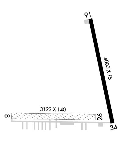
Runway Identifications
Runway Identification: 08/26Length: 3123 ft
Width: 140 ft
Surface: GRASS-GOOD CONDITION
Edge lights: Treatment: NONE
| | Runway: 08 | | Runway: 26 |
| Mag heading: | 87° | Mag heading: | 267° |
| Rwy Slope: | .07% Up | Rwy Slope: | -.07% Down |
| Approach: | | Approach: | |
| Pattern: | Left Traffic | Pattern: | Left Traffic |
| Markings: | | Markings: | |
| Marking Condition: | YELLOW CONES. | Marking Condition: | YELLOW CONES. |
| Arresting Dev: | | Arresting Dev: | |
| Lat & Long: | N4632.7 W09341.1 | Lat. & Long.: | N4632.8 W09340.4 |
| Elev: | 1203.5 ft. MSL | Elev: | 1205.8 ft. MSL |
| TCH: | | TCH: | |
| Visual Glide Path: | | Visual Glide Path: | |
| Displaced Threshold: | 240 feet | Displaced Threshold: | No |
| Touchdown Zone: | YES | Touchdown Zone: | YES |
| Touchdown Elev.: | 1205.8 feet | Touchdown Elev.: | 1205.9 feet |
| Visual Glide Slope: | | Visual Glide Slope: | |
| RVR Equipment: | | RVR Equipment: | |
| RVV Equipment: | NO | RVV Equipment: | NO |
| Approach Lights: | | Approach Lights: | |
| REIL: | NO | REIL: | NO |
| Centerline Lights: | NO | Centerline Lights: | NO |
| Touchdown lights: | NO | Touchdown lights: | NO |
| Runway Category: | Runway with a Visual Approach | Runway Category: | Runway with a Visual Approach |
| Declared Distances: | TORA:3123' TODA:3123' ASDA:3123' LDA:2883' | Declared Distances: | |
| Obstructions: | TREES | Obstructions: | TREES |
| Marked: | NOT Marked/Lighted | Marked: | NOT Marked/Lighted |
| Clearance slope: | 17:1 | Clearance slope: | 18:1 |
| Obstruction height: | 33 feet AGL | Obstruction height: | 44 feet AGL |
| Dist. from runway: | 565 feet | Dist. from runway: | 818 feet |
| Centerline offset: | 102 left of centerline | Centerline offset: | 97 feet right of centerline |
| Comments: | | Comments: | |
Runway Identification: 16/34Length: 4000 ft
Width: 75 ft
Surface: ASPHALT-FAIR CONDITION
Edge lights: Medium IntensityTreatment: NONE
| | Runway: 16 | | Runway: 34 |
| Mag heading: | 164° | Mag heading: | 344° |
| Rwy Slope: | .01% Up | Rwy Slope: | -.01% Down |
| Approach: | | Approach: | |
| Pattern: | Left Traffic | Pattern: | Left Traffic |
| Markings: | NONPRECISION INSTRUMENT | Markings: | NONPRECISION INSTRUMENT |
| Marking Condition: | GOOD | Marking Condition: | GOOD |
| Arresting Dev: | | Arresting Dev: | |
| Lat & Long: | N4633.4 W09340.6 | Lat. & Long.: | N4632.7 W09340.3 |
| Elev: | 1205.7 ft. MSL | Elev: | 1205.9 ft. MSL |
| TCH: | 26 ft. AGL | TCH: | 39 ft. AGL |
| Visual Glide Path: | 3.00 degrees | Visual Glide Path: | 3.00 degrees |
| Displaced Threshold: | No | Displaced Threshold: | No |
| Touchdown Zone: | YES | Touchdown Zone: | YES |
| Touchdown Elev.: | 1206.0 feet | Touchdown Elev.: | 1206.0 feet |
| Visual Glide Slope: | 2-Box VASI on LEFT side of Runway | Visual Glide Slope: | 2-Box VASI on LEFT side of Runway |
| RVR Equipment: | | RVR Equipment: | |
| RVV Equipment: | NO | RVV Equipment: | NO |
| Approach Lights: | | Approach Lights: | |
| REIL: | YES | REIL: | YES |
| Centerline Lights: | NO | Centerline Lights: | NO |
| Touchdown lights: | NO | Touchdown lights: | NO |
| Runway Category: | Runway with a Non-precision Approach | Runway Category: | Runway with a Non-precision Approach |
| Declared Distances: | | Declared Distances: | |
| Obstructions: | | Obstructions: | TREE |
| Marked: | | Marked: | NOT Marked/Lighted |
| Clearance slope: | | Clearance slope: | 15:1 |
| Obstruction height: | | Obstruction height: | 96 feet AGL |
| Dist. from runway: | | Dist. from runway: | 1644 feet |
| Centerline offset: | | Centerline offset: | 445 feet left of centerline |
| Comments: | | Comments: | |

