Current Weather/Notams (Metars, TAFs, Notams, NWS Forecast, PIREPS, and nearby weather)
Customs Information Send updates to Support@FltPlan.com
Customs Not Available
Database effective 05/16/2024
Airport Diagram might not be current.
|
| Facility Name: | ATLANTIC MUNI |
| City Name: | ATLANTIC |
| County: | CASS |
| State abbrev: | IA |
| State Name: | IOWA |
| | |
| Ownership: | PUBLICLY OWNED |
| Use: | OPEN TO THE PUBLIC |
| Owner's Name: | CITY OF ATLANTIC |
| Address: | 23 E. 4TH ST. |
| | ATLANTIC, IA 50022 |
| Owner's Phone: | 712-243-4810 |
| | |
| Manager's Name: | BARRY REID |
| Address: | 59706 AIRPORT RD; EMAIL ADDRESS: AIRWORKSAIO@GMAIL.COM (ALL LOWER CASE) |
| | ATLANTIC, IA 50022 |
| Phone: | 712-243-3056 |
| | |
| FAA Region: | CENTRAL |
| FAA Field Office: | NONE |
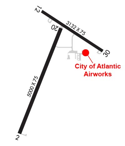
Runway Identifications
Runway Identification: 02/20Length: 5000 ft
Width: 75 ft
Surface: CONCRETE-GOOD CONDITION
Edge lights: Medium IntensityTreatment: NONE
Weight: PCN 6 /R/C/W/U
| | Runway: 02 | | Runway: 20 |
| Mag heading: | 18° | Mag heading: | 198° |
| Rwy Slope: | .06% Up | Rwy Slope: | -.06% Down |
| Approach: | | Approach: | |
| Pattern: | Left Traffic | Pattern: | Left Traffic |
| Markings: | NONPRECISION INSTRUMENT | Markings: | NONPRECISION INSTRUMENT |
| Marking Condition: | FAIR | Marking Condition: | FAIR |
| Arresting Dev: | | Arresting Dev: | |
| Lat & Long: | N4123.7 W09503.2 | Lat. & Long.: | N4124.5 W09502.8 |
| Elev: | 1145.9 ft. MSL | Elev: | 1149.0 ft. MSL |
| TCH: | 31 ft. AGL | TCH: | 31 ft. AGL |
| Visual Glide Path: | 3.00 degrees | Visual Glide Path: | 3.00 degrees |
| Displaced Threshold: | No | Displaced Threshold: | No |
| Touchdown Zone: | YES | Touchdown Zone: | YES |
| Touchdown Elev.: | 1150.8 feet | Touchdown Elev.: | 1151.2 feet |
| Visual Glide Slope: | 2-Light PAPI on LEFT side of Runway | Visual Glide Slope: | 2-Light PAPI on LEFT side of Runway |
| RVR Equipment: | | RVR Equipment: | |
| RVV Equipment: | NO | RVV Equipment: | NO |
| Approach Lights: | | Approach Lights: | |
| REIL: | YES | REIL: | YES |
| Centerline Lights: | NO | Centerline Lights: | NO |
| Touchdown lights: | NO | Touchdown lights: | NO |
| Runway Category: | Runway with a Non-precision Approach having visibility minimums greater than 3/4 mile | Runway Category: | Runway with a Non-precision Approach having visibility minimums greater than 3/4 mile |
| Declared Distances: | | Declared Distances: | |
Runway Identification: 12/30Length: 3132 ft
Width: 75 ft
Surface: ASPHALT-GOOD CONDITION
Edge lights: Medium IntensityTreatment: NONE
Weight: PCN 6 /F/C/X/U
| | Runway: 12 | | Runway: 30 |
| Mag heading: | 119° | Mag heading: | 299° |
| Rwy Slope: | -.67% Down | Rwy Slope: | .67% Up |
| Approach: | | Approach: | |
| Pattern: | Left Traffic | Pattern: | Left Traffic |
| Markings: | NONPRECISION INSTRUMENT | Markings: | NONPRECISION INSTRUMENT |
| Marking Condition: | GOOD | Marking Condition: | GOOD |
| Arresting Dev: | | Arresting Dev: | |
| Lat & Long: | N4124.6 W09503.0 | Lat. & Long.: | N4124.3 W09502.5 |
| Elev: | 1164.9 ft. MSL | Elev: | 1143.8 ft. MSL |
| TCH: | | TCH: | |
| Visual Glide Path: | | Visual Glide Path: | |
| Displaced Threshold: | 290 feet | Displaced Threshold: | No |
| Touchdown Zone: | YES | Touchdown Zone: | YES |
| Touchdown Elev.: | 1160.5 feet | Touchdown Elev.: | 1162.7 feet |
| Visual Glide Slope: | | Visual Glide Slope: | |
| RVR Equipment: | | RVR Equipment: | |
| RVV Equipment: | NO | RVV Equipment: | NO |
| Approach Lights: | | Approach Lights: | |
| REIL: | NO | REIL: | NO |
| Centerline Lights: | NO | Centerline Lights: | NO |
| Touchdown lights: | NO | Touchdown lights: | NO |
| Runway Category: | Runway with a Visual Approach | Runway Category: | Runway with a Visual Approach |
| Declared Distances: | TORA:3132' TODA:3132' ASDA:3132' LDA:2842' | Declared Distances: | TORA:3132' TODA:3132' ASDA:3132' LDA:3132' |
| Obstructions: | TREE | Obstructions: | BRUSH |
| Marked: | NOT Marked/Lighted | Marked: | NOT Marked/Lighted |
| Clearance slope: | 14:1; APCH SLOPE 20:1 TO DSPLCD THLD. | Clearance slope: | 20:1 |
| Obstruction height: | 73 feet AGL | Obstruction height: | 15 feet AGL |
| Dist. from runway: | 1287 feet | Dist. from runway: | 385 feet |
| Centerline offset: | 75 right of centerline | Centerline offset: | 110 feet right of centerline |
| Comments: | 13 FT ROAD @ 80 FT ON CNTRLN. | Comments: | |