Click here for more info on on SMS!

KAID

ANDERSON MUNI-DARLINGTON FIELD
ANDERSON
IN
Time Zone: Eastern
Lat: N 4006.5
Long: W 08536.8
Elev: 919
Var: +03
Longest Runway: 5400
AWOS: 128.55
Ground: 121.6
Tower: 126.0

FBO & Flight Services info for KAID

FBOs: Update your Fuel Prices

  click here  
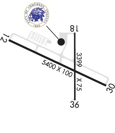
The Anderson Municipal Airport provides an air traffic control tower, state-of-the-art facilities, passenger and cargo terminal, and two large runways. The airport offers one of the lowest air fuel and hangar rental costs in the region and owns and operates the adjacent Aero Industrial Park. Anderson Municipal is not only a great airport for pilots, but it also a great opportunity for business.
Ph: 765-648-6293 Fax: 765-648-6294 Freq: 122.95WebsiteE-Mail
                     
Service
Jet
100LL
SAF
MoGas
Fuel Avail: FBO hours 8:30 am - 4:30 pm Monday- Saturday. Call 765-639-4611 for after-hours.
Full5.886.58    Last Update: 04/09/2024 10:09
PRICES GUARANTEED by FBO.
Self5.386.08  4.98
Misc. Info: FBO (765) 639-4611 after hours. MOGAS is 90+ OCT No AlcoholAddress: 282 AIRPORT ROAD,   ANDERSON, IN 46017

AWOSPh: 765-378-1510
-
Freq: 128.55  
If you are an FBO, call 1-203-262-1700 to update your info or email: FltPlan.Advertising@garmin.com
Advertise your FBO on FltPlan.com

Runway & Approach Info for KAID
Rwy
Length
Land Dist**
Approach*
  Rwy
Length
Land Dist**
Approach*
12
5400x100  5400'          
 
  
30
  5400x100  5320'          
ILS
 110.10 - 298°  
18
3399x75  3108'          
 
  
36
  3399x75  3111'          
 
 * only ILS, LOC, LDA, and SDF approaches to a specific runway are shown
** For any Declared Landing Distance Available, please see A/FD or Approach plates
Runway Weight Capability (lbs.) Help
Runway IDSingle WheelDouble WheelDouble Tandem WheelDual Double Wheel
12/30112,000158,000279,000N/A
18/3638,50056,500N/AN/A
These numbers are Advisory and are not limits.   The Airport Manager should have more accurate Weight Limits
Approach Charts
Approaches    
Current Weather/Notams
Customs Information Send updates to Support@FltPlan.com
Customs Not Available
Database effective 05/16/2024
Airport Diagram of KAID
Airport Diagram might not be current.

Facility Name: ANDERSON MUNI-DARLINGTON FLD
City Name: ANDERSON
County: MADISON
State abbrev: IN
State Name: INDIANA
   
Ownership: PUBLICLY OWNED
Use: OPEN TO THE PUBLIC
Owner's Name: CITY OF ANDERSON
Address: 282 AIRPORT RD
 ANDERSON, IN 46017
Owner's Phone: 765-648-6293
  
Manager's Name: BRIAN MCMILLEN
Address: 282 AIRPORT RD.
 ANDERSON, IN 46017
Phone: 765-648-6292
   
FAA Region: GREAT LAKES
FAA Field Office: CHI


Sunrise / Sunset times for ANDERSON MUNI-DARLINGTON FLD

DateSunriseSunset
04/22/24 Monday6:5320:29
04/23/24 Tuesday6:5220:30
04/24/24 Wednesday6:5020:31
04/25/24 Thursday6:4920:32
04/26/24 Friday6:4820:33
04/27/24 Saturday6:4620:34
04/28/24 Sunday6:4520:35
04/29/24 Monday6:4420:36
04/30/24 Tuesday6:4320:37
05/01/24 Wednesday6:4120:38
05/02/24 Thursday6:4020:39
05/03/24 Friday6:3920:40
05/04/24 Saturday6:3820:41
05/05/24 Sunday6:3720:42

Airport Facilities

Airport Attendance ScheduleMON-FRI 0700-1800, SAT-SUN ON CALL; UNATNDD MARTIN LUTHER KING, PRES, ELECTION, EASTER, MEMORIAL, INDEPENDENCE, LABOR, VETERANS, THANKSGIVING, CHRISTMAS, NEW YEARS DAYS & GOOD FRIDAY; AFT HR - AMGR.
Airport Status OPERATIONAL (This Status can change at any time - please check NOTAMS)
Airport Lighting ScheduleWHEN TWR CLSD ACTVT MALSF RWY 30; PAPI RWY 12 & 18; MIRL RWY 12/30 & 18/36 - CTAF.
Airport Storage AvailableTie Downs, Hanger
Extra Services AvailableAir Freight, Charter, Flight Instruction, Aircraft Rental, Aircraft Sales
Wind IndicatorYES - (lighted)
Control TowerYES
CTAF Frequency126.000
Unicom Frequency122.950
Rotating Beacon ColorWG
Segmented CircleYES
Landing FeeNO

Airport Inspection Data

Airport InspectedFEDERAL - performed by STATE AERONAUTICAL PERSONNEL
Inspection Date06/07/2022

Airport Services

Type of Fuel AvailableGrade 100LL, JET A (freeze point -40C)MOGAS
Airframe Repair ServiceMAJOR
Power Plant Repair ServiceMAJOR

Geographic Data

LatitudeN4006.5
LongitudeW08536.8 (ESTIMATED)
Arpt Elevation919ft (SURVEYED)
Magnetic Variation03W
3 miles Eof ANDERSON
Traffic Pattern Altitude
Sectional ChartCHICAGO

Aircraft Data

Operations (Reported)YearlyAvg. Daily
General Aviation Transient 871224
General Aviation Local 929225
Air Taxi 11623
Commerical 00
Commuter 00
Military 1931
Aircraft based on Field
General Aviation Singles 98
General Aviation Multi 5
Jet Aircraft 0
General Aviation Helicopters 2
Military Aircraft 0
Gliders 0
Ultralights 0

FAA Services

FSS on field NO
FSS tie-in TERRE HAUTE
FSS Phone 1-800-WX-BRIEF
Who issues Notams AID
Notam D service at airport YES
ARTCC Name INDIANAPOLIS

Federal Status

Airport Certification
Aircraft Rescue & Firefighting IndexNone
Airport of EntryNo
Custom Landing RightsNo
Joint Civil/MilitaryNo
Military Landing rightsYES

Federal Agreements

NATIONAL PLAN OF INTEGRATED AIRPORT SYSTEMS (NPIAS)
GRANT AGREEMENTS UNDER FAAP/ADAP/AIP
ASSURANCES PURSUANT TO TITLE VI, CIVIL RIGHTS ACT OF 1964

Remarks

DEP RWY 12, 18 & 36 UN TO SEE EACH OTHER.
DEER ON & INVOF ARPT.
TWY B CLSD INDEFLY.
WHEN ATCT IS CLSD FOR CD CTC INDIANAPOLIS APCH AT 317-227-5743.
GND COM OUTLET 121.725 COMMISSIONED KEY FREQ 4 TIMES.
TRML NOT STAFFED ON SUNDAYS - AMGR.
SELF SERVE FUEL AVBL H24.
RWY 18/3 6 NOT AVBL TO ACR MORE THAN 30 PAX SEATS.
Airport Communications & Frequencies:
ANDERSON Tower Frequencies:   Hours(local) of operation: 0830-1630 MON-SAT   
126.0
ANDERSON Ground Frequencies:
121.6
CTAF Frequency:
126.000
Unicom Frequency:
122.950
Remarks
  • APCH/DEP SVC PRVDD BY INDIANAPOLIS TRACON ON FREQS 120.65/317.8.
  • INDIANAPOLIS Primary Approach Frequencies:  
    120.65
    317.8
    INDIANAPOLIS Primary Departure Frequencies:  
    120.65
    317.8
    Runway Identifications
    Runway Identification: 12/30
    Length: 5400 ft
    Width: 100 ft
    Surface: ASPHALT
    Edge lights: Medium Intensity

    Treatment: GROOVED
    Weight: PCN 44 /F/C/Y/T

     Runway: 12   Runway: 30
    Mag heading: 118°Mag heading: 298°
    Rwy Slope: .72% UpRwy Slope: -.72% Down
    Approach: Approach: ILS
    Pattern: Left TrafficPattern: Left Traffic
    Markings: PRECISION INSTRUMENTMarkings: PRECISION INSTRUMENT
    Marking Condition: GOODMarking Condition: GOOD
    Arresting Dev: Arresting Dev:
    Lat & Long: N4006.7  W08537.4Lat. & Long.: N4006.3  W08536.3
    Elev: 880.1 ft. MSLElev: 919.0 ft. MSL
    TCH: 45 ft. AGLTCH: 48 ft. AGL
    Visual Glide Path: 3.00 degreesVisual Glide Path: 3.00 degrees
    Displaced Threshold: NoDisplaced Threshold: 80 feet
    Touchdown Zone: YESTouchdown Zone: YES
    Touchdown Elev.: 896.9 feetTouchdown Elev.: 918.9 feet
    Visual Glide Slope: 4-Light PAPI on LEFT side of RunwayVisual Glide Slope: 4-Light PAPI on LEFT side of Runway
    RVR Equipment: RVR Equipment:
    RVV Equipment: NORVV Equipment: NO
    Approach Lights: Approach Lights: MALSF - 1,400 foot medium intensity approach lighting system with sequenced flashers
    REIL: YESREIL: NO
    Centerline Lights: NOCenterline Lights: NO
    Touchdown lights: NOTouchdown lights: NO
    Runway Category: Runway with a Visual ApproachRunway Category: D
    Declared Distances: Declared Distances:
    Obstructions: TREESObstructions: TREES
    Marked: NOT Marked/LightedMarked: NOT Marked/Lighted
    Clearance slope: 13:1Clearance slope: 30:1; APCH RATIO 35:1 TO DSPLCD THR.
    Obstruction height: 117 feet AGLObstruction height: 50 feet AGL
    Dist. from runway: 1831 feetDist. from runway: 1700 feet
    Centerline offset: 519 right of centerlineCenterline offset: 30 feet left of centerline
    Comments: Comments:
    Runway Identification: 18/36
    Length: 3399 ft
    Width: 75 ft
    Surface: ASPHALT-GOOD CONDITION
    Edge lights: Medium Intensity

    Treatment: GROOVED
    Weight: PCN 14 /F/C/Y/T

     Runway: 18   Runway: 36
    Mag heading: 183°Mag heading:
    Rwy Slope: -.14% DownRwy Slope: .14% Up
    Approach: Approach:
    Pattern: Left TrafficPattern: Left Traffic
    Markings: BASICMarkings: BASIC
    Marking Condition: FAIRMarking Condition: FAIR
    Arresting Dev: Arresting Dev:
    Lat & Long: N4006.8  W08536.7Lat. & Long.: N4006.2  W08536.7
    Elev: 912.7 ft. MSLElev: 908.0 ft. MSL
    TCH: 30 ft. AGLTCH:
    Visual Glide Path: 3.00 degreesVisual Glide Path:
    Displaced Threshold: 291 feetDisplaced Threshold: 288 feet
    Touchdown Zone: YESTouchdown Zone: YES
    Touchdown Elev.: 912.2 feetTouchdown Elev.: 912.5 feet
    Visual Glide Slope: 2-Light PAPI on LEFT side of RunwayVisual Glide Slope:
    RVR Equipment: RVR Equipment:
    RVV Equipment: NORVV Equipment: NO
    Approach Lights: Approach Lights:
    REIL: NOREIL: NO
    Centerline Lights: NOCenterline Lights: NO
    Touchdown lights: NOTouchdown lights: NO
    Runway Category: Runway with a Visual ApproachRunway Category: Runway with a Visual Approach
    Declared Distances: LDA:3108'Declared Distances: LDA:3111'
    Obstructions: TREEObstructions: TREES
    Marked: NOT Marked/LightedMarked: NOT Marked/Lighted
    Clearance slope: 17:1; APCH RATIO 24:1 TO DSPLCD THR.Clearance slope: 17:1; APCH RATIO 22:1 TO DSPLCD THR.
    Obstruction height: 63 feet AGLObstruction height: 98 feet AGL
    Dist. from runway: 1314 feetDist. from runway: 1900 feet
    Centerline offset: 134 right of centerlineCenterline offset: 100 feet left of centerline
    Comments: 11 FT RD 170 FT FM RWY END.Comments:
    C:4/P: