KAIA

ALLIANCE MUNI
ALLIANCE
NE
Time Zone: Mountain
Lat: N 4203.2
Long: W 10248.2
Elev: 3931
Var: -07
Longest Runway: 9203
AWOS: 135.07
CTAF: 123.0

FBO & Flight Services info for KAIA

FBOs: Update your Fuel Prices

HEARTLAND AVPh: 308-762-5311
-
Freq: 123.0
Service
Jet
100LL
SAF
MoGas
Fuel Avail: Fuel Available After Hours, 7:30am-5:30pm Monday- Friday 8am- 4pm Saturday and Sunday
Full5.205.80    Last Update: 04/07/2024 13:25

Self        
 Address: 5641 SARPY RD   ALLIANCE, NE 69301
ASOSPh: 308-762-1221
-
Freq: 135.07  
If you are an FBO, call 1-203-262-1700 to update your info or email: FltPlan.Advertising@garmin.com
Advertise your FBO on FltPlan.com

Runway & Approach Info for KAIA
Rwy
Length
Land Dist**
Approach*
  Rwy
Length
Land Dist**
Approach*
08
6190x75  6190'          
 
  
26
  6190x75  6190'          
 
12
9203x150  9203'          
 
  
30
  9203x150  9203'          
ILS/DME
 108.35 - 307°  
17
6311x75  6311'          
 
  
35
  6311x75  6311'          
 
 * only ILS, LOC, LDA, and SDF approaches to a specific runway are shown
** For any Declared Landing Distance Available, please see A/FD or Approach plates
Runway Weight Capability (lbs.) Help
Runway IDSingle WheelDouble WheelDouble Tandem WheelDual Double Wheel
08/2636,00048,00080,000N/A
12/3036,00048,00080,000N/A
17/3524,00030,000N/AN/A
These numbers are Advisory and are not limits.   The Airport Manager should have more accurate Weight Limits
Approach Charts
Approaches    
Current Weather/Notams
Customs Information Send updates to Support@FltPlan.com
Customs Not Available
Database effective 04/18/2024
Airport Diagram of KAIA
Airport Diagram might not be current.

Facility Name: ALLIANCE MUNI
City Name: ALLIANCE
County: BOX BUTTE
State abbrev: NE
State Name: NEBRASKA
   
Ownership: PUBLICLY OWNED
Use: OPEN TO THE PUBLIC
Owner's Name: CITY OF ALLIANCE
Address: PO BOX D
 ALLIANCE, NE 69301
Owner's Phone: 308-762-5400
  
Manager's Name: MS LYNN PLACEK
Address: 5631 SARPY ROAD, PO BOX D
 ALLIANCE, NE 69301
Phone: 308-762-4512
   
FAA Region: CENTRAL
FAA Field Office: NONE


Sunrise / Sunset times for ALLIANCE MUNI

DateSunriseSunset
04/19/24 Friday6:0319:38
04/20/24 Saturday6:0219:39
04/21/24 Sunday6:0019:40
04/22/24 Monday5:5919:41
04/23/24 Tuesday5:5719:42
04/24/24 Wednesday5:5619:43
04/25/24 Thursday5:5419:44
04/26/24 Friday5:5319:46
04/27/24 Saturday5:5119:47
04/28/24 Sunday5:5019:48
04/29/24 Monday5:4919:49
04/30/24 Tuesday5:4719:50
05/01/24 Wednesday5:4619:51
05/02/24 Thursday5:4519:52

Airport Facilities

Airport Attendance ScheduleCONTINUOUS
Airport Status OPERATIONAL (This Status can change at any time - please check NOTAMS)
Airport Lighting ScheduleACTVT MALSR RWY 30; REIL RWY 12; VASI RWY 12; PAPI RWY 30 & MIRL RWY 12/30 & 08/26 -CTAF.
Airport Storage AvailableTie Downs, Hanger
Extra Services AvailableCrop Dusting, Flight Instruction, Aircraft Rental, Aircraft Sales
Wind IndicatorYES - (lighted)
Control TowerNO
CTAF Frequency123.000
Unicom Frequency123.000
Rotating Beacon ColorWG
Segmented CircleYES
Landing FeeNO

Airport Inspection Data

Airport InspectedFEDERAL - performed by FAA AIRPORTS FIELD PERSONNEL
Inspection Date07/18/2023

Airport Services

Type of Fuel AvailableGrade 100LL, JET A (freeze point -40C)
Airframe Repair ServiceMAJOR
Power Plant Repair ServiceMAJOR

Geographic Data

LatitudeN4203.2
LongitudeW10248.2 (ESTIMATED)
Arpt Elevation3930ft (SURVEYED)
Magnetic Variation07E
3 miles SEof ALLIANCE
Traffic Pattern Altitude
Sectional ChartCHEYENNE

Aircraft Data

Operations (Reported)YearlyAvg. Daily
General Aviation Transient 350110
General Aviation Local 817022
Air Taxi 1020
Commerical 12353
Commuter 00
Military 100
Aircraft based on Field
General Aviation Singles 50
General Aviation Multi 3
Jet Aircraft 0
General Aviation Helicopters 0
Military Aircraft 0
Gliders 1
Ultralights 0

FAA Services

FSS on field NO
FSS tie-in COLUMBUS
FSS Phone 1-800-WX-BRIEF
Who issues Notams AIA
Notam D service at airport YES
ARTCC Name DENVER

Federal Status

Airport CertificationAIRPORT RECEIVING SCHEDULED AIR CARRIER SERVICE FROM CARRIERS CERTIFICATED BY THE CIVIL AERONAUTICS BOARD; RWY 17/35 NOT AVBL FOR SKED ACR OPNS WITH MORE THAN 9 PSGR SEATS OR UNSKED ACR AT LEAST 31 PSGR SEATS.
Aircraft Rescue & Firefighting IndexAIRPORT HAS A CERTIFICATE UNDER CFR PART 139
Airport of EntryNo
Custom Landing RightsNo
Joint Civil/MilitaryNo
Military Landing rightsYES

Federal Agreements

NATIONAL PLAN OF INTEGRATED AIRPORT SYSTEMS (NPIAS)
GRANT AGREEMENTS UNDER FAAP/ADAP/AIP
SURPLUS PROPERTY AGREEMENT UNDER PUBLIC LAW 289
ASSURANCES PURSUANT TO TITLE VI, CIVIL RIGHTS ACT OF 1964

Remarks

RY 17/35 UNAVBL FOR USE BY AIR CARRIERS.
FOR CD IF UNA TO CTC ON FSS FREQ, CTC DENVER ARTCC AT 303-651-4257.
ULTRALIGHT & GLIDER OPNS ON & INVOF ARPT.
AERIAL SPRAYING OPNS ON & INVOF ARPT.
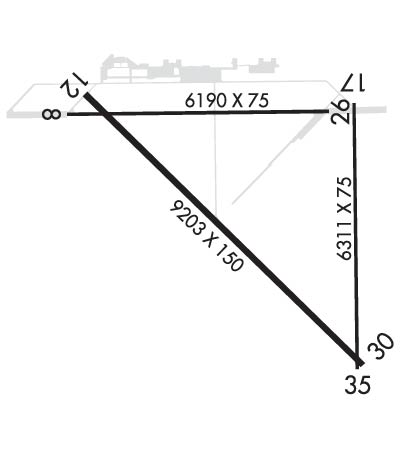
RY 08/26 DESIGNATED CALM WIND.
HAYING OPNS ON INTERIOR OF ARPT DURG SUMMER MONTHS.
OCCASIONAL USE BY ACFT WITH NO RADIO.
BACK TAXIING.
MIGRATORY WATERFOWL ON & INVOF ARPT.
Airport Communications & Frequencies:
CTAF Frequency:
123.000
Unicom Frequency:
123.000
Remarks
  • APCH/DEP CTL SVC PRVDD BY DENVER ARTCC (ZDV) ON FREQS 127.95/338.2 (CRAWFORD RCAG).
  • Runway Identifications
    Runway Identification: 08/26
    Length: 6190 ft
    Width: 75 ft
    Surface: ASPHALT-GOOD CONDITION
    Edge lights: Medium Intensity

    Treatment: POROUS FRICTION COURSE
    Weight: PCN 28 /F/A/W/U

     Runway: 08   Runway: 26
    Mag heading: 82°Mag heading: 262°
    Rwy Slope: -.09% DownRwy Slope: .09% Up
    Approach: Approach:
    Pattern: Left TrafficPattern: Left Traffic
    Markings: NONPRECISION INSTRUMENTMarkings: NONPRECISION INSTRUMENT
    Marking Condition: GOODMarking Condition: GOOD
    Arresting Dev: Arresting Dev:
    Lat & Long: N4203.5  W10249.2Lat. & Long.: N4203.5  W10247.8
    Elev: 3930.6 ft. MSLElev: 3924.9 ft. MSL
    TCH: TCH:
    Visual Glide Path: Visual Glide Path:
    Displaced Threshold: NoDisplaced Threshold: No
    Touchdown Zone: YESTouchdown Zone: YES
    Touchdown Elev.: 3930.6 feetTouchdown Elev.: 3926.8 feet
    Visual Glide Slope: Visual Glide Slope:
    RVR Equipment: RVR Equipment:
    RVV Equipment: NORVV Equipment: NO
    Approach Lights: Approach Lights:
    REIL: NOREIL: NO
    Centerline Lights: NOCenterline Lights: NO
    Touchdown lights: NOTouchdown lights: NO
    Runway Category: Runway with a Non-precision Approach having visibility minimums greater than 3/4 mileRunway Category: Runway with a Non-precision Approach having visibility minimums greater than 3/4 mile
    Declared Distances: TORA:6190' TODA:6190' ASDA:6190' LDA:6190'Declared Distances: TORA:6200' TODA:6200' ASDA:6200' LDA:6200'
    Runway Identification: 12/30
    Length: 9203 ft
    Width: 150 ft
    Surface: ASPHALT
    Edge lights: Medium Intensity

    Treatment: AGGREGATE FRICTION SEAL COAT
    Weight: PCN 42 /F/A/W/U

     Runway: 12   Runway: 30
    Mag heading: 127°Mag heading: 307°
    Rwy Slope: -.06% DownRwy Slope: .06% Up
    Approach: Approach: ILS/DME
    Pattern: Left TrafficPattern: Left Traffic
    Markings: NONPRECISION INSTRUMENTMarkings: PRECISION INSTRUMENT
    Marking Condition: GOODMarking Condition: GOOD
    Arresting Dev: Arresting Dev:
    Lat & Long: N4203.6  W10249.1Lat. & Long.: N4202.5  W10247.7
    Elev: 3929.8 ft. MSLElev: 3924.5 ft. MSL
    TCH: 39 ft. AGLTCH: 53 ft. AGL
    Visual Glide Path: 3.00 degreesVisual Glide Path: 3.00 degrees
    Displaced Threshold: NoDisplaced Threshold: No
    Touchdown Zone: YESTouchdown Zone: YES
    Touchdown Elev.: 3930.2 feetTouchdown Elev.: 3927.2 feet
    Visual Glide Slope: 4-BOX VASI ON LEFT SIDE OF RUNWAYVisual Glide Slope: 4-Light PAPI on LEFT side of Runway
    RVR Equipment: RVR Equipment:
    RVV Equipment: NORVV Equipment: NO
    Approach Lights: Approach Lights: MALSR - 1,400 foot medium intensity approach lighting system with runway alignment indicator lights
    REIL: YESREIL: NO
    Centerline Lights: NOCenterline Lights: NO
    Touchdown lights: NOTouchdown lights: NO
    Runway Category: Runway with a Non-precision Approach having visibility minimums greater than 3/4 mileRunway Category: Precision Instrument Runway
    Declared Distances: TORA:9202' TODA:9202' ASDA:9202' LDA:9202'Declared Distances: TORA:9202' TODA:9202' ASDA:9202' LDA:9202'
    Runway Identification: 17/35
    Length: 6311 ft
    Width: 75 ft
    Surface: ASPHALT-POOR CONDITION
    Edge lights:

    Treatment: NONE
    Weight: PCN 17 /F/A/W/U

     Runway: 17   Runway: 35
    Mag heading: 172°Mag heading: 352°
    Rwy Slope: .01% UpRwy Slope: -.01% Down
    Approach: Approach:
    Pattern: Left TrafficPattern: Left Traffic
    Markings: BASICMarkings: BASIC
    Marking Condition: FAIRMarking Condition: FAIR
    Arresting Dev: Arresting Dev:
    Lat & Long: N4203.6  W10247.7Lat. & Long.: N4202.5  W10247.7
    Elev: 3924.6 ft. MSLElev: 3925.2 ft. MSL
    TCH: TCH:
    Visual Glide Path: Visual Glide Path:
    Displaced Threshold: NoDisplaced Threshold: No
    Touchdown Zone: YESTouchdown Zone: YES
    Touchdown Elev.: 3925.0 feetTouchdown Elev.: 3925.2 feet
    Visual Glide Slope: Visual Glide Slope:
    RVR Equipment: RVR Equipment:
    RVV Equipment: NORVV Equipment: NO
    Approach Lights: Approach Lights:
    REIL: NOREIL: NO
    Centerline Lights: NOCenterline Lights: NO
    Touchdown lights: NOTouchdown lights: NO
    Runway Category: Runway with a Visual ApproachRunway Category: Runway with a Visual Approach
    Declared Distances: TORA:6311' TODA:6311' ASDA:6311' LDA:6311'Declared Distances: TORA:6311' TODA:6311' ASDA:6311' LDA:6311'
    C:12/P: