Current Weather/Notams (Metars, TAFs, Notams, NWS Forecast, PIREPS, and nearby weather)
Customs Information Send updates to Support@FltPlan.com
Customs Not Available
Database effective 04/18/2024
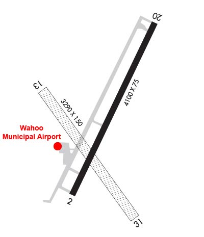
Airport Diagram might not be current. Facility Name: WAHOO MUNI City Name: WAHOO County: SAUNDERS State abbrev: NE State Name: NEBRASKA Ownership: PUBLICLY OWNED Use: OPEN TO THE PUBLIC Owner's Name: WAHOO AIRPORT AUTHORITY; JAY MORROW - ARPT AUTH CHAIRMAN. Address: PO BOX 122 WAHOO, NE 68066-0122 Owner's Phone: 402-443-3222 Manager's Name: EVAN TAYLOR Address: PO BOX 122 WAHOO, NE 68066-0122 Phone: (402) 882-2717 FAA Region: CENTRAL FAA Field Office: NONE
Runway Identifications Help
Runway Identification: 02/20 Length: 4100 ftWidth: 75 ftSurface: CONCRETE-GOOD CONDITIONEdge lights: Medium Intensity Treatment: NONE Runway: 02 Runway: 20 Mag heading: 18° Mag heading: 198° Rwy Slope: .09% Up Rwy Slope: -.09% Down Approach: Approach: Pattern: Left Traffic Pattern: Left Traffic Markings: NONPRECISION INSTRUMENT Markings: NONPRECISION INSTRUMENT Marking Condition: GOOD Marking Condition: GOOD Arresting Dev: Arresting Dev: Lat & Long: N4114.2 W09635.8 Lat. & Long.: N4114.8 W09635.4 Elev: 1220.1 ft. MSL Elev: 1223.7 ft. MSL TCH: 40 ft. AGL TCH: 40 ft. AGL Visual Glide Path: 3.00 degrees Visual Glide Path: 3.00 degrees Displaced Threshold: No Displaced Threshold: No Touchdown Zone: YES Touchdown Zone: YES Touchdown Elev.: 1223.0 feet Touchdown Elev.: 1223.7 feet Visual Glide Slope: 2-Light PAPI on LEFT side of Runway Visual Glide Slope: 2-Light PAPI on LEFT side of Runway RVR Equipment: RVR Equipment: RVV Equipment: NO RVV Equipment: NO Approach Lights: Approach Lights: REIL: YES REIL: YES Centerline Lights: NO Centerline Lights: NO Touchdown lights: NO Touchdown lights: NO Runway Category: Runway with a Non-precision Approach Runway Category: Runway with a Non-precision Approach Declared Distances: Declared Distances: Obstructions: ELEVATOR LEG. Obstructions: Marked: NOT Marked/Lighted Marked: Clearance slope: 20:1; RWY 02 HWY 850 FT FM END 0B ALSO 36:1. Clearance slope: 20:1 Obstruction height: Obstruction height: Dist. from runway: Dist. from runway: Centerline offset: Centerline offset: Comments: Comments:
Runway Identification: 13/31 Length: 3290 ftWidth: 150 ftSurface: GRASS-FAIR CONDITIONEdge lights: Treatment: NONE Runway: 13 Runway: 31 Mag heading: 135° Mag heading: 315° Rwy Slope: -.09% Down Rwy Slope: .09% Up Approach: Approach: Pattern: Left Traffic Pattern: Left Traffic Markings: Markings: Marking Condition: Marking Condition: Arresting Dev: Arresting Dev: Lat & Long: N4114.6 W09636.0 Lat. & Long.: N4114.1 W09635.5 Elev: 1223.0 ft. MSL Elev: 1220.0 ft. MSL TCH: TCH: Visual Glide Path: Visual Glide Path: Displaced Threshold: No Displaced Threshold: No Touchdown Zone: YES Touchdown Zone: YES Touchdown Elev.: 1223.0 feet Touchdown Elev.: 1223.0 feet Visual Glide Slope: Visual Glide Slope: RVR Equipment: RVR Equipment: RVV Equipment: NO RVV Equipment: NO Approach Lights: Approach Lights: REIL: NO REIL: NO Centerline Lights: NO Centerline Lights: NO Touchdown lights: NO Touchdown lights: NO Runway Category: Runway with a Visual Approach Runway Category: Runway with a Visual Approach Declared Distances: Declared Distances: