
| ||||||
| ||||||
|
| Rwy | Rwy | |||||||
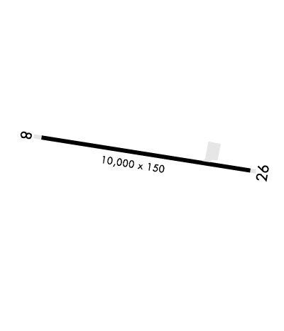
| 10000x150 | 10000' | 10000x150 | 10000' | |||||
| Runway ID | Single Wheel | Double Wheel | Double Tandem Wheel | Dual Double Wheel |
| 09/27 | N/A | N/A | N/A | N/A |
| These numbers are Advisory and are not limits. The Airport Manager should have more accurate Weight Limits | ||||
 Airport Diagram might not be current. | |
| Facility Name: | AMEDEE AAF |
| City Name: | HERLONG |
| County: | LASSEN |
| State abbrev: | CA |
| State Name: | CALIFORNIA |
| Ownership: | ARMY OWNED |
| Use: | PRIVATE |
| Owner's Name: | US ARMY AERONAUTICAL SVCS AGENCY |
| Address: | |
| FT BELVOIR, VA 22060 | |
| Owner's Phone: | |
| Manager's Name: | DAN DONOVAN |
| Address: | |
| Phone: | 530-827-4147 |
| FAA Region: | WESTERN-PACIFIC |
| FAA Field Office: | SFO |
| Date | Sunrise | Sunset |
|---|---|---|
| 04/25/24 Thursday | 6:07 | 19:51 |
| 04/26/24 Friday | 6:05 | 19:52 |
| 04/27/24 Saturday | 6:04 | 19:53 |
| 04/28/24 Sunday | 6:03 | 19:54 |
| 04/29/24 Monday | 6:02 | 19:55 |
| 04/30/24 Tuesday | 6:00 | 19:56 |
| 05/01/24 Wednesday | 5:59 | 19:57 |
| 05/02/24 Thursday | 5:58 | 19:58 |
| 05/03/24 Friday | 5:57 | 19:59 |
| 05/04/24 Saturday | 5:55 | 20:00 |
| 05/05/24 Sunday | 5:54 | 20:01 |
| 05/06/24 Monday | 5:53 | 20:02 |
| 05/07/24 Tuesday | 5:52 | 20:03 |
| 05/08/24 Wednesday | 5:51 | 20:04 |
| Airport Attendance Schedule | UNATTENDED |
| Airport Status | OPERATIONAL (This Status can change at any time - please check NOTAMS) |
| Airport Lighting Schedule | |
| Airport Storage Available | NONE |
| Extra Services Available | NONE |
| Wind Indicator | NONE |
| Control Tower | NO |
| CTAF Frequency | 126.200 |
| Unicom Frequency | |
| Rotating Beacon Color | |
| Segmented Circle | NO |
| Landing Fee |
| Airport Inspected | No Inspection Data Available performed by the OWNER |
| Inspection Date | Unknown |
| Type of Fuel Available | None |
| Airframe Repair Service | None |
| Power Plant Repair Service | None |
| Latitude | N4016.0 |
| Longitude | W12009.0 (ESTIMATED) |
| Arpt Elevation | 4011ft (ESTIMATED) |
| Magnetic Variation | 13E |
| 9 miles N | of HERLONG |
| Traffic Pattern Altitude | |
| Sectional Chart | KLAMATH FALLS |
| Operations (Reported) | Yearly | Avg. Daily |
|---|---|---|
| General Aviation Transient | 0 | 0 |
| General Aviation Local | 0 | 0 |
| Air Taxi | 0 | 0 |
| Commerical | 0 | 0 |
| Commuter | 0 | 0 |
| Military | 0 | 0 |
| Aircraft based on Field | |
|---|---|
| General Aviation Singles | 0 |
| General Aviation Multi | 0 |
| Jet Aircraft | 0 |
| General Aviation Helicopters | 0 |
| Military Aircraft | 0 |
| Gliders | 0 |
| Ultralights | 0 |
| FSS on field | NO |
| FSS tie-in | RENO |
| FSS Phone | 1-800-WX-BRIEF |
| Who issues Notams | RNO |
| Notam D service at airport | YES |
| ARTCC Name | OAKLAND |
| Airport Certification | |
| Aircraft Rescue & Firefighting Index | None |
| Airport of Entry | No |
| Custom Landing Rights | No |
| Joint Civil/Military | No |
| Military Landing rights | No |
| PPR FROM AIRFIELD COORDINATOR V855-4193 C916-827-4293. |
| PPR AND APCH CALL RQRD PRIOR TO LDG. |
| DALGT OPS ONLY UNLESS WAIVER GRANTED BY AFLD MGR. |
| FOR CD CTC OAKLAND ARTCC AT 510-745-3380. |
Airport Communications & Frequencies:
| |||||||
| Runway: 09 | Runway: 27 | ||
| Mag heading: | N/A | Mag heading: | N/A |
| Rwy Slope: | .05% Up | Rwy Slope: | -.05% Down |
| Approach: | Approach: | ||
| Pattern: | Left Traffic | Pattern: | Left Traffic |
| Markings: | Markings: | ||
| Marking Condition: | Marking Condition: | ||
| Arresting Dev: | Arresting Dev: | ||
| Lat & Long: | N4016.1 W12010.1 | Lat. & Long.: | N4015.8 W12008.0 |
| Elev: | 4006.5 ft. MSL | Elev: | 4011.6 ft. MSL |
| TCH: | TCH: | 87 ft. AGL | |
| Visual Glide Path: | Visual Glide Path: | 3.00 degrees | |
| Displaced Threshold: | No | Displaced Threshold: | No |
| Touchdown Zone: | YES | Touchdown Zone: | YES |
| Touchdown Elev.: | 4008.2 feet | Touchdown Elev.: | 4011.6 feet |
| Visual Glide Slope: | Visual Glide Slope: | 4-Light PAPI on LEFT side of Runway | |
| RVR Equipment: | RVR Equipment: | ||
| RVV Equipment: | NO | RVV Equipment: | NO |
| Approach Lights: | Approach Lights: | ||
| REIL: | NO | REIL: | NO |
| Centerline Lights: | NO | Centerline Lights: | NO |
| Touchdown lights: | NO | Touchdown lights: | NO |
| Runway Category: | Runway Category: | ||
| Declared Distances: | Declared Distances: |
