Click here for more info on on SMS!

KAFW

FORT WORTH ALLIANCE
FORT WORTH
TX
Time Zone: Central
Lat: N 3259.4
Long: W 09719.2
Elev: 723
Var: -04
Longest Runway: 11125
Clr Del: 128.72
Dept. ATIS: 126.92
Arr. ATIS: 126.92
AWOS: 126.92
Ground: 132.65
Tower: 135.15

FBO & Flight Services info for KAFW

FBOs: Update your Fuel Prices

  click here  
Dedicated to providing superior service that exceeds every customer's expectations. State of the art facilities including a crew lounge, military briefing room, conference rooms and a private gym. Complimentary Infiniti courtesy vehicles, onsite Enterprise rentals, onsite Customs, catering & hotel reservations. Proud member of the exclusive Air Elite Network through World Fuel Services.
Ph: 800-318-9268 Fax: 817-430-2875 Freq: 129.75Website-
                   
Service
Jet
100LL
SAF
MoGas
Fuel Avail: Fuel available M-F 6am-10pm. After hours available upon request.
Full6.807.15    Last Update: 04/16/2024 10:55

Self        
Misc. Info: Weekend 100LL discount ($0.50)Address: 13901 AVIATOR WAY,   FORT WORTH, TX 76177

ASOSPh: 817-491-8625
-
-
 
If you are an FBO, call 1-203-262-1700 to update your info or email: FltPlan.Advertising@garmin.com
Advertise your FBO on FltPlan.com

Runway & Approach Info for KAFW
Rwy
Length
Land Dist**
Approach*
  Rwy
Length
Land Dist**
Approach*
16L
11000x150  11000'          
ILS/DME
 110.15 - 166°  
  
34R
  11000x150  11000'          
ILS/DME
 110.15 - 346°  
16R
11125x150  11125'          
 
  
34L
  11125x150  10409'          
 
 * only ILS, LOC, LDA, and SDF approaches to a specific runway are shown
** For any Declared Landing Distance Available, please see A/FD or Approach plates
Runway Weight Capability (lbs.) Help
Runway IDSingle WheelDouble WheelDouble Tandem WheelDual Double Wheel
16L/34RN/A200,000400,000870,000
16R/34LN/A200,000400,000870,000
These numbers are Advisory and are not limits.   The Airport Manager should have more accurate Weight Limits
Approach Charts
Approaches    
Current Weather/Notams
Customs Information Send updates to Support@FltPlan.com
Phone 817-890-1000
Fax 817-491-8355

Comments Phone ext 3122. 2 hrs advance notice required. Business hrs 0830-1700 Monday-Friday. Saturday and Sunday when approved by 1600 Friday. Alternate phone 214-868-7828.
Database effective 04/18/2024
Airport Diagram of KAFW
Airport Diagram might not be current.

Facility Name: PEROT FLD/FORT WORTH ALLIANCE
City Name: FORT WORTH
County: TARRANT
State abbrev: TX
State Name: TEXAS
   
Ownership: PUBLICLY OWNED
Use: OPEN TO THE PUBLIC
Owner's Name: CITY OF FORT WORTH
Address: 1000 THROCKMORTON
 FORT WORTH, TX 76177
Owner's Phone: 817-392-6116
  
Manager's Name: CHRISTIAN CHILDS
Address: 2221 ALLIANCE BLVD SUITE 100
 FORT WORTH, TX 76177
Phone: 817-890-1000
   
FAA Region: SOUTHWEST
FAA Field Office: TEX
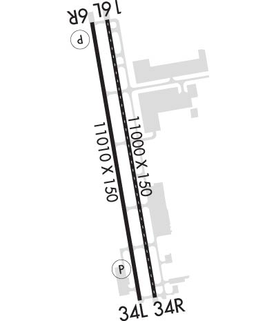

Sunrise / Sunset times for PEROT FLD/FORT WORTH ALLIANCE

DateSunriseSunset
04/18/24 Thursday6:5520:02
04/19/24 Friday6:5420:03
04/20/24 Saturday6:5320:04
04/21/24 Sunday6:5220:05
04/22/24 Monday6:5020:05
04/23/24 Tuesday6:4920:06
04/24/24 Wednesday6:4820:07
04/25/24 Thursday6:4720:08
04/26/24 Friday6:4620:08
04/27/24 Saturday6:4520:09
04/28/24 Sunday6:4420:10
04/29/24 Monday6:4320:11
04/30/24 Tuesday6:4220:11
05/01/24 Wednesday6:4120:12

Airport Facilities

Airport Attendance ScheduleCONTINUOUS
Airport Status OPERATIONAL (This Status can change at any time - please check NOTAMS)
Airport Lighting ScheduleSS-SR
Airport Storage AvailableTie Downs, Hanger
Extra Services AvailableAvionics, Cargo Handling
Wind IndicatorYES - (lighted)
Control TowerYES
CTAF Frequency
Unicom FrequencyARINC FREQ 129.75 AVBL.
Rotating Beacon ColorWG
Segmented CircleYES
Landing Fee

Airport Inspection Data

Airport InspectedFEDERAL - performed by FAA AIRPORTS FIELD PERSONNEL
Inspection Date04/20/2023

Airport Services

Type of Fuel AvailableGrade 100LL, JET A-1 (icing inhibitor, freeze point -50C)
Airframe Repair ServiceMAJOR; PRIOR ARRANGEMENTS REQUIRED FOR AIRFRAME OR POWER PLANT REPAIRS FOR DESIGN GROUP III & ABOVE.
Power Plant Repair ServiceMAJOR

Geographic Data

LatitudeN3259.4
LongitudeW09719.2 (ESTIMATED)
Arpt Elevation723ft (SURVEYED)
Magnetic Variation04E
14 miles Nof FORT WORTH
Traffic Pattern Altitude
Sectional ChartDALLAS-FT WORTH

Aircraft Data

Operations (Reported)YearlyAvg. Daily
General Aviation Transient 3500896
General Aviation Local 3163787
Air Taxi 1206133
Commerical 1995755
Commuter 00
Military 1098930
Aircraft based on Field
General Aviation Singles 1
General Aviation Multi 5
Jet Aircraft 8
General Aviation Helicopters 8
Military Aircraft 0
Gliders 0
Ultralights 0

FAA Services

FSS on field NO
FSS tie-in FORT WORTH
FSS Phone 1-800-WX-BRIEF
Who issues Notams AFW
Notam D service at airport YES
ARTCC Name FORT WORTH

Federal Status

Airport CertificationARFF INDEX E AVAILABLE. PPR FOR ACR OPNS WITH MORE THAN 30 PSGR SEATS CALL 817-890-1000 OR 800-318-9268.
Aircraft Rescue & Firefighting IndexAIRPORT HAS A CERTIFICATE UNDER CFR PART 139
Airport of EntryNo
Custom Landing RightsNo; US CUSTOMS USER FEE ARPT.
Joint Civil/MilitaryNo
Military Landing rightsYES

Federal Agreements

NATIONAL PLAN OF INTEGRATED AIRPORT SYSTEMS (NPIAS)
GRANT AGREEMENTS UNDER FAAP/ADAP/AIP
ASSURANCES PURSUANT TO TITLE VI, CIVIL RIGHTS ACT OF 1964

Remarks

FLIGHT NOTIFICATION SERVICE (ADCUS) AVBL.
PORTIONS OF TWY H MOVEMENT AREA EAST OF TWY A IS NOT VISIBLE FROM ATCT.
Airport Communications & Frequencies:
ATIS Frequencies:   Hours(local) of Operation: CONTINUOUS
126.925
ALLIANCE Tower Frequencies:   Hours(local) of operation: CONTINUOUS   
120.825 ;HELICOPTERS
135.15
257.9
ALLIANCE Ground Frequencies:
132.65
306.2
Clearance Delivery Frequencies:
128.725
Unicom Frequency:
ARINC FREQ 129.75 AVBL.
Remarks
  • EMERGENCY FREQ NOT AVBL.
  • REGIONAL Primary Approach Frequencies:  
    118.1
    306.95
    REGIONAL Primary Departure Frequencies:  
    118.1
    306.95
    Runway Identifications
    Runway Identification: 16L/34R
    Length: 11000 ft
    Width: 150 ft
    Surface: CONCRETE-GOOD CONDITION
    Edge lights: High Intensity

    Treatment: GROOVED
    Weight: PCN 82 /R/B/W/T

     Runway: 16L   Runway: 34R
    Mag heading: 166°Mag heading: 346°
    Rwy Slope: -.54% DownRwy Slope: .54% Up
    Approach: ILS/DMEApproach: ILS/DME
    Pattern: Right TrafficPattern: Left Traffic
    Markings: PRECISION INSTRUMENTMarkings: PRECISION INSTRUMENT
    Marking Condition: GOODMarking Condition: GOOD
    Arresting Dev: Arresting Dev:
    Lat & Long: N3300.3  W09719.3Lat. & Long.: N3258.5  W09718.9
    Elev: 723.1 ft. MSLElev: 664.2 ft. MSL
    TCH: TCH:
    Visual Glide Path: Visual Glide Path:
    Displaced Threshold: NoDisplaced Threshold: No
    Touchdown Zone: YESTouchdown Zone: YES
    Touchdown Elev.: 723.2 feetTouchdown Elev.: 681.0 feet
    Visual Glide Slope: Visual Glide Slope:
    RVR Equipment: TOUCHDOWN-MIDFIELD-ROLLOUTRVR Equipment: TOUCHDOWN-MIDFIELD-ROLLOUT
    RVV Equipment: NORVV Equipment: NO
    Approach Lights: ALSF2 - standard 2,400 foot high intensity approach lighting system with sequenced flashers, Category II or IIIApproach Lights: MALSR - 1,400 foot medium intensity approach lighting system with runway alignment indicator lights
    REIL: NOREIL: NO
    Centerline Lights: YESCenterline Lights: YES
    Touchdown lights: YESTouchdown lights: YES
    Runway Category: Precision Instrument RunwayRunway Category: Precision Instrument Runway
    Declared Distances: TORA:10600' TODA:10600' ASDA:10600' LDA:10600'Declared Distances: TORA:11000' TODA:11000' ASDA:11000' LDA:11000'
    Obstructions: Obstructions: PLINE
    Marked: Marked: LIGHTED
    Clearance slope: 50:1Clearance slope: 42:1
    Obstruction height: Obstruction height: 182 feet AGL
    Dist. from runway: Dist. from runway: 7920 feet
    Centerline offset: Centerline offset: 590 feet right of centerline
    Comments: Comments:
    Runway Identification: 16R/34L
    Length: 11125 ft
    Width: 150 ft
    Surface: CONCRETE-GOOD CONDITION
    Edge lights: High Intensity

    Treatment: GROOVED
    Weight: PCN 82 /R/B/W/T

     Runway: 16R   Runway: 34L
    Mag heading: 166°Mag heading: 346°
    Rwy Slope: -.51% DownRwy Slope: .51% Up
    Approach: Approach:
    Pattern: Right TrafficPattern: Left Traffic
    Markings: PRECISION INSTRUMENTMarkings: PRECISION INSTRUMENT
    Marking Condition: GOODMarking Condition: GOOD
    Arresting Dev: Arresting Dev:
    Lat & Long: N3300.3  W09719.4Lat. & Long.: N3258.5  W09719.0
    Elev: 721.2 ft. MSLElev: 664.7 ft. MSL
    TCH: 82 ft. AGLTCH: 74 ft. AGL
    Visual Glide Path: 3.00 degreesVisual Glide Path: 3.00 degrees
    Displaced Threshold: NoDisplaced Threshold: 716 feet
    Touchdown Zone: YESTouchdown Zone: YES
    Touchdown Elev.: 721.2 feetTouchdown Elev.: 686.6 feet
    Visual Glide Slope: 4-Light PAPI on RIGHT side of RunwayVisual Glide Slope: 4-Light PAPI on LEFT side of Runway
    RVR Equipment: RVR Equipment:
    RVV Equipment: NORVV Equipment: NO
    Approach Lights: Approach Lights:
    REIL: YESREIL: YES
    Centerline Lights: NOCenterline Lights: NO
    Touchdown lights: NOTouchdown lights: NO
    Runway Category: Runway with a Visual ApproachRunway Category: Runway with a Visual Approach
    Declared Distances: TORA:11010' TODA:11010' ASDA:10410' LDA:10410'Declared Distances: TORA:11010' TODA:11010' ASDA:11010' LDA:10409'
    Obstructions: RRObstructions: FENCE
    Marked: NOT Marked/LightedMarked: NOT Marked/Lighted
    Clearance slope: 21:1; APCH RATIO 0:1 BASED ON DSPLCD THLD; +5 FT FENCE 0 FT, 250 FT R.Clearance slope: APCH RATIO 50:1 TO DSPLCD THLD.
    Obstruction height: 19 feet AGLObstruction height: 4 feet AGL
    Dist. from runway: 607 feetDist. from runway: 200 feet
    Centerline offset: 287 right of centerlineCenterline offset: 250 feet left of centerline
    Comments: Comments: +4 FT FENCE 0 FT 250 FT L; APCH RATIO 0:1 BASED ON DSPLCD THLD.
    C:71/P: