Click here for more info on on SMS!

KAFP

ANSON COUNTY
WADESBORO
NC
Time Zone: Eastern
Lat: N 3501.2
Long: W 08004.6
Elev: 300
Var: +07
Longest Runway: 5498
AWOS: 119.32
CTAF: 122.8

FBO & Flight Services info for KAFP

FBOs: Update your Fuel Prices
Service is offered at the airport from 8:30 a.m. until 5 p.m. Monday through Friday. The airport offers 100LL Avgas, Jet-A Fuel, a courtesy car, tie downs, and a pilots lounge. The 100LL Avgas is self-service and available 24 hours a day with a valid credit card. Jet-A fuel is by pump service and does require an Airport Attendant to assist. Please call in advance for jet fuel.
Ph: 704-389-0633
-
Freq: 122.8Website-
Service
Jet
100LL
SAF
MoGas
Fuel Avail: PRIST PREMIXED. Phone 704-398-0633 for jet fuel after hours
Full5.24      Last Update: 04/01/2024 09:47

Self  5.47    
Misc. Info: Address: 2980 AIRPORT RD   WADESBORO, NC 28170

AWOSPh: 704-695-0623
-
Freq: 119.32  
If you are an FBO, call 1-203-262-1700 to update your info or email: FltPlan.Advertising@garmin.com
Advertise your FBO on FltPlan.com

Runway & Approach Info for KAFP
Rwy
Length
Land Dist**
Approach*
  Rwy
Length
Land Dist**
Approach*
16
5498x100  5498'          
 
  
34
  5498x100  5498'          
ILS/DME
 108.55 - 341°  
 * only ILS, LOC, LDA, and SDF approaches to a specific runway are shown
** For any Declared Landing Distance Available, please see A/FD or Approach plates
Runway Weight Capability (lbs.) Help
Runway IDSingle WheelDouble WheelDouble Tandem WheelDual Double Wheel
16/3412,00060,000N/AN/A
These numbers are Advisory and are not limits.   The Airport Manager should have more accurate Weight Limits
Approach Charts
Approaches    
Current Weather/Notams
Customs Information Send updates to Support@FltPlan.com
Customs Not Available
Database effective 04/18/2024
Airport Diagram of KAFP
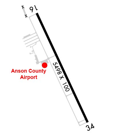
Airport Diagram might not be current.

Facility Name: ANSON COUNTY/JEFF CLOUD FLD
City Name: WADESBORO
County: ANSON
State abbrev: NC
State Name: NORTH CAROLINA
   
Ownership: PUBLICLY OWNED
Use: OPEN TO THE PUBLIC
Owner's Name: ANSON COUNTY
Address: 101 S. GREENE STREET
 WADESBORO, NC 28170
Owner's Phone: 704-994-3200
  
Manager's Name: REX EDWARDS
Address: 2980 AIRPORT ROAD
 WADESBORO, NC 28170
Phone: (704) 389-0633
   
FAA Region: SOUTHERN
FAA Field Office: MEM


Sunrise / Sunset times for ANSON COUNTY/JEFF CLOUD FLD

DateSunriseSunset
04/18/24 Thursday6:4419:56
04/19/24 Friday6:4219:57
04/20/24 Saturday6:4119:58
04/21/24 Sunday6:4019:58
04/22/24 Monday6:3919:59
04/23/24 Tuesday6:3820:00
04/24/24 Wednesday6:3620:01
04/25/24 Thursday6:3520:02
04/26/24 Friday6:3420:02
04/27/24 Saturday6:3320:03
04/28/24 Sunday6:3220:04
04/29/24 Monday6:3120:05
04/30/24 Tuesday6:3020:06
05/01/24 Wednesday6:2920:06

Airport Facilities

Airport Attendance ScheduleMON-FRI 0830-1700; FOR AFT HRS SVC CALL 704-389-0633.
Airport Status OPERATIONAL (This Status can change at any time - please check NOTAMS)
Airport Lighting ScheduleACTVT REILS RWY 16 & 34; PAPI RWY 16 & 34; MIRL RWY 16/34 - CTAF.
Airport Storage AvailableTie Downs
Extra Services AvailableNONE
Wind IndicatorYES - (lighted)
Control TowerNO
CTAF Frequency122.800
Unicom Frequency122.800
Rotating Beacon ColorWG
Segmented CircleYES
Landing FeeNO

Airport Inspection Data

Airport InspectedSTATE - performed by STATE AERONAUTICAL PERSONNEL
Inspection Date05/29/2023

Airport Services

Type of Fuel AvailableGrade 100LL, JET A-1 (icing inhibitor, freeze point -50C); -10100LL FUEL - 24 HR SELF SVC AVBL WITH CREDIT CARD.; -A1FOR JET-A AFT HRS CALL FBO DURG OFC HRS FOR PRE-ARNGMT.
Airframe Repair ServiceNONE
Power Plant Repair ServiceNONE

Geographic Data

LatitudeN3501.2
LongitudeW08004.6 (ESTIMATED)
Arpt Elevation299ft (SURVEYED)
Magnetic Variation07W
3 miles Nof WADESBORO
Traffic Pattern Altitude
Sectional ChartCHARLOTTE

Aircraft Data

Operations (Reported)YearlyAvg. Daily
General Aviation Transient 400011
General Aviation Local 25007
Air Taxi 00
Commerical 00
Commuter 00
Military 150
Aircraft based on Field
General Aviation Singles 20
General Aviation Multi 0
Jet Aircraft 1
General Aviation Helicopters 4
Military Aircraft 0
Gliders 0
Ultralights 0

FAA Services

FSS on field NO
FSS tie-in RALEIGH
FSS Phone 1-800-WX-BRIEF
Who issues Notams RDU
Notam D service at airport YES
ARTCC Name ATLANTA

Federal Status

Airport Certification
Aircraft Rescue & Firefighting IndexNone
Airport of EntryNo
Custom Landing RightsNo
Joint Civil/MilitaryNo
Military Landing rightsNo

Federal Agreements

NATIONAL PLAN OF INTEGRATED AIRPORT SYSTEMS (NPIAS)

Remarks

DEER IN VICINITY OF ARPT.
FOR CD CTC CHARLOTTE APCH AT 704-359-0241.
RWY 34 HAS 60+ FT UNMARKED POWER LINES 2700 FT FM THR BOTH SIDES OF CNTRLN.
Airport Communications & Frequencies:
CTAF Frequency:
122.800
Unicom Frequency:
122.800
CHARLOTTE Primary Approach Frequencies:  
120.05
307.8
CHARLOTTE Primary Departure Frequencies:  
120.05
307.8
Runway Identifications
Runway Identification: 16/34
Length: 5498 ft
Width: 100 ft
Surface: ASPHALT
Edge lights: Medium Intensity

Treatment: NONE

 Runway: 16   Runway: 34
Mag heading: 162°Mag heading: 342°
Rwy Slope: -.05% DownRwy Slope: .05% Up
Approach: Approach: ILS/DME
Pattern: Left TrafficPattern: Left Traffic
Markings: NONPRECISION INSTRUMENTMarkings: PRECISION INSTRUMENT
Marking Condition: GOODMarking Condition: GOOD
Arresting Dev: Arresting Dev:
Lat & Long: N3501.6  W08004.9Lat. & Long.: N3500.8  W08004.4
Elev: 299.3 ft. MSLElev: 296.8 ft. MSL
TCH: 44 ft. AGLTCH: 45 ft. AGL
Visual Glide Path: 3.00 degreesVisual Glide Path: 3.00 degrees
Displaced Threshold: NoDisplaced Threshold: No
Touchdown Zone: YESTouchdown Zone: YES
Touchdown Elev.: 299.7 feetTouchdown Elev.: 299.3 feet
Visual Glide Slope: 4-Light PAPI on LEFT side of RunwayVisual Glide Slope: 4-Light PAPI on LEFT side of Runway
RVR Equipment: RVR Equipment:
RVV Equipment: NORVV Equipment: NO
Approach Lights: Approach Lights:
REIL: YESREIL: YES
Centerline Lights: NOCenterline Lights: NO
Touchdown lights: NOTouchdown lights: NO
Runway Category: Runway with a Non-precision Approach having visibility minimums greater than 3/4 mileRunway Category: Precision Instrument Runway
Declared Distances: Declared Distances:
Obstructions: TREESObstructions: TREES
Marked: NOT Marked/LightedMarked: NOT Marked/Lighted
Clearance slope: 14:1Clearance slope: 16:1
Obstruction height: 83 feet AGLObstruction height: 23 feet AGL
Dist. from runway: 1426 feetDist. from runway: 579 feet
Centerline offset: 221 right of centerlineCenterline offset: 356 feet right of centerline
Comments: 14 FT TREES 139 FT FROM END OF RWY AND OFFSET 308 FT RIGHT OF CNTRLN.Comments: 17 FT HILL 0-200 FT FROM END OF RWY AND 364 FT LEFT OF CNTRLN.
C:2/P: