Current Weather/Notams (Metars, TAFs, Notams, NWS Forecast, PIREPS, and nearby weather)
Customs Information Send updates to Support@FltPlan.com
Customs Not Available
Database effective 05/16/2024
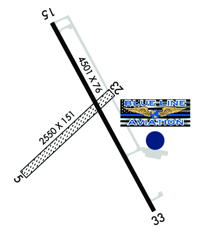
Airport Diagram might not be current. Facility Name: NEBRASKA CITY MUNI City Name: NEBRASKA CITY County: OTOE State abbrev: NE State Name: NEBRASKA Ownership: PUBLICLY OWNED Use: OPEN TO THE PUBLIC Owner's Name: CITY OF NEBRASKA CITY; PERRY MADER, CITY ADMIR (402) 873-5515. Address: 1409 CENTRAL AVE NEBRASKA CITY, NE 68410-2223 Owner's Phone: (402) 873-5515 Manager's Name: KYLE GRESS Address: 972 S. 64TH ROAD NEBRASKA CITY, NE 68410-6805 Phone: 402-873-0550 FAA Region: CENTRAL FAA Field Office: NONE
Runway Identifications Help
Runway Identification: 05/23 Length: 2550 ftWidth: 151 ftSurface: GRASS-GOOD CONDITIONEdge lights: Treatment: NONE Runway: 05 Runway: 23 Mag heading: 43° Mag heading: 223° Rwy Slope: -.19% Down Rwy Slope: .19% Up Approach: Approach: Pattern: Left Traffic Pattern: Left Traffic Markings: Markings: Marking Condition: Marking Condition: Arresting Dev: Arresting Dev: Lat & Long: N4036.2 W09552.3 Lat. & Long.: N4036.5 W09551.9 Elev: 1164.8 ft. MSL Elev: 1159.9 ft. MSL TCH: TCH: Visual Glide Path: Visual Glide Path: Displaced Threshold: No Displaced Threshold: No Touchdown Zone: YES Touchdown Zone: YES Touchdown Elev.: 1165.0 feet Touchdown Elev.: 1165.0 feet Visual Glide Slope: Visual Glide Slope: RVR Equipment: RVR Equipment: RVV Equipment: NO RVV Equipment: NO Approach Lights: Approach Lights: REIL: NO REIL: NO Centerline Lights: NO Centerline Lights: NO Touchdown lights: NO Touchdown lights: NO Runway Category: Runway with a Visual Approach Runway Category: Runway with a Visual Approach Declared Distances: Declared Distances:
Runway Identification: 15/33 Length: 4501 ftWidth: 76 ftSurface: CONCRETE-GOOD CONDITIONEdge lights: Medium Intensity Treatment: NONE Runway: 15 Runway: 33 Mag heading: 146° Mag heading: 326° Rwy Slope: .02% Up Rwy Slope: -.02% Down Approach: Approach: Pattern: Left Traffic Pattern: Left Traffic Markings: NONPRECISION INSTRUMENT Markings: NONPRECISION INSTRUMENT Marking Condition: GOOD Marking Condition: GOOD Arresting Dev: Arresting Dev: Lat & Long: N4036.7 W09552.2 Lat. & Long.: N4036.1 W09551.7 Elev: 1156.7 ft. MSL Elev: 1157.6 ft. MSL TCH: 52 ft. AGL TCH: 52 ft. AGL Visual Glide Path: 3.00 degrees Visual Glide Path: 3.00 degrees Displaced Threshold: No Displaced Threshold: No Touchdown Zone: YES Touchdown Zone: YES Touchdown Elev.: 1162.1 feet Touchdown Elev.: 1162.1 feet Visual Glide Slope: 2-Light PAPI on LEFT side of Runway Visual Glide Slope: 2-Light PAPI on LEFT side of Runway RVR Equipment: RVR Equipment: RVV Equipment: NO RVV Equipment: NO Approach Lights: Approach Lights: REIL: NO REIL: NO Centerline Lights: NO Centerline Lights: NO Touchdown lights: NO Touchdown lights: NO Runway Category: Runway with a Non-precision Approach having visibility minimums greater than 3/4 mile Runway Category: Runway with a Non-precision Approach having visibility minimums greater than 3/4 mile Declared Distances: Declared Distances: