Current Weather/Notams (Metars, TAFs, Notams, NWS Forecast, PIREPS, and nearby weather)
Customs Information Send updates to Support@FltPlan.com
Customs Not Available
Database effective 05/16/2024
Airport Diagram might not be current.
|
| Facility Name: | ALEXANDRIA INTL |
| City Name: | ALEXANDRIA |
| County: | RAPIDES |
| State abbrev: | LA |
| State Name: | LOUISIANA |
| | |
| Ownership: | PUBLICLY OWNED |
| Use: | OPEN TO THE PUBLIC |
| Owner's Name: | ENGLAND AUTHORITY |
| Address: | 1611 ARNOLD DR |
| | ALEXANDRIA, LA 71303 |
| Owner's Phone: | 318-449-3504 |
| | |
| Manager's Name: | SCOTT GAMMEL |
| Address: | 1611 ARNOLD DR |
| | ALEXANDRIA, LA 71303 |
| Phone: | 318-427-6419 |
| | |
| FAA Region: | SOUTHWEST |
| FAA Field Office: | LNM |
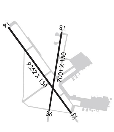
Runway Identifications
Runway Identification: 14/32Length: 9352 ft
Width: 150 ft
Surface: CONCRETE-GOOD CONDITION
Edge lights: High IntensityTreatment: GROOVED
| | Runway: 14 | | Runway: 32 |
| Mag heading: | 141° | Mag heading: | 321° |
| Rwy Slope: | .05% Up | Rwy Slope: | -.05% Down |
| Approach: | LOC/GS | Approach: | |
| Pattern: | Left Traffic | Pattern: | Left Traffic |
| Markings: | PRECISION INSTRUMENT | Markings: | PRECISION INSTRUMENT |
| Marking Condition: | GOOD | Marking Condition: | GOOD |
| Arresting Dev: | MA-1A MOD | Arresting Dev: | MA-1A MOD |
| Lat & Long: | N3120.3 W09233.6 | Lat. & Long.: | N3119.0 W09232.5 |
| Elev: | 83.7 ft. MSL | Elev: | 88.0 ft. MSL |
| TCH: | 71 ft. AGL | TCH: | 80 ft. AGL |
| Visual Glide Path: | 3.00 degrees | Visual Glide Path: | 3.00 degrees |
| Displaced Threshold: | No | Displaced Threshold: | No |
| Touchdown Zone: | YES | Touchdown Zone: | YES |
| Touchdown Elev.: | 85.0 feet | Touchdown Elev.: | 88.1 feet |
| Visual Glide Slope: | 4-Light PAPI on LEFT side of Runway | Visual Glide Slope: | 4-Light PAPI on LEFT side of Runway |
| RVR Equipment: | TOUCHDOWN-ROLLOUT | RVR Equipment: | TOUCHDOWN-ROLLOUT |
| RVV Equipment: | NO | RVV Equipment: | NO |
| Approach Lights: | MALSR - 1,400 foot medium intensity approach lighting system with runway alignment indicator lights | Approach Lights: | |
| REIL: | NO | REIL: | YES |
| Centerline Lights: | NO | Centerline Lights: | NO |
| Touchdown lights: | YES | Touchdown lights: | NO |
| Runway Category: | Precision Instrument Runway | Runway Category: | Runway with a Non-precision Approach having visibility minimums greater than 3/4 mile |
| Declared Distances: | TORA:9352' TODA:9352' ASDA:9352' LDA:9352' | Declared Distances: | TORA:9352' TODA:9352' ASDA:9352' LDA:9352' |
Runway Identification: 18/36Length: 7001 ft
Width: 150 ft
Surface: CONCRETE ASPHALT-GOOD CONDITION
Edge lights: High IntensityTreatment: GROOVED
| | Runway: 18 | | Runway: 36 |
| Mag heading: | 186° | Mag heading: | 6° |
| Rwy Slope: | .05% Up | Rwy Slope: | -.05% Down |
| Approach: | | Approach: | |
| Pattern: | Left Traffic | Pattern: | Left Traffic |
| Markings: | NONPRECISION INSTRUMENT | Markings: | NONPRECISION INSTRUMENT |
| Marking Condition: | GOOD | Marking Condition: | GOOD |
| Arresting Dev: | | Arresting Dev: | |
| Lat & Long: | N3120.2 W09232.7 | Lat. & Long.: | N3119.1 W09232.9 |
| Elev: | 83.5 ft. MSL | Elev: | 86.7 ft. MSL |
| TCH: | 79 ft. AGL | TCH: | 77 ft. AGL |
| Visual Glide Path: | 3.00 degrees | Visual Glide Path: | 3.00 degrees |
| Displaced Threshold: | No | Displaced Threshold: | No |
| Touchdown Zone: | YES | Touchdown Zone: | YES |
| Touchdown Elev.: | 84.0 feet | Touchdown Elev.: | 86.8 feet |
| Visual Glide Slope: | 4-Light PAPI on LEFT side of Runway | Visual Glide Slope: | 4-Light PAPI on LEFT side of Runway |
| RVR Equipment: | | RVR Equipment: | |
| RVV Equipment: | NO | RVV Equipment: | NO |
| Approach Lights: | | Approach Lights: | |
| REIL: | YES | REIL: | YES |
| Centerline Lights: | NO | Centerline Lights: | NO |
| Touchdown lights: | NO | Touchdown lights: | NO |
| Runway Category: | Runway with a Non-precision Approach having visibility minimums greater than 3/4 mile | Runway Category: | Runway with a Visual Approach |
| Declared Distances: | TORA:7001' TODA:7001' ASDA:7001' LDA:7001' | Declared Distances: | TORA:7001' TODA:7001' ASDA:7001' LDA:7001' |
| Obstructions: | | Obstructions: | TREES |
| Marked: | | Marked: | NOT Marked/Lighted |
| Clearance slope: | 34:1 | Clearance slope: | 21:1 |
| Obstruction height: | | Obstruction height: | 76 feet AGL |
| Dist. from runway: | | Dist. from runway: | 1798 feet |
| Centerline offset: | | Centerline offset: | 322 feet right of centerline |
| Comments: | | Comments: | |

