Current Weather/Notams (Metars, TAFs, Notams, NWS Forecast, PIREPS, and nearby weather)
Customs Information Send updates to Support@FltPlan.com
Customs Not Available
Database effective 05/16/2024
Airport Diagram might not be current.
|
| Facility Name: | ALBERT LEA MUNI |
| City Name: | ALBERT LEA |
| County: | FREEBORN |
| State abbrev: | MN |
| State Name: | MINNESOTA |
| | |
| Ownership: | PUBLICLY OWNED |
| Use: | OPEN TO THE PUBLIC |
| Owner's Name: | CITY OF ALBERT LEA |
| Address: | 221 E CLARK STREET |
| | ALBERT LEA, MN 56007 |
| Owner's Phone: | 507-377-4300 |
| | |
| Manager's Name: | JIM HANSON |
| Address: | 73950 275TH ST.; EMAIL ADDRESS: JIMHANSON@DESKMEDIA.COM (ALL LOWER CASE) |
| | CLARKS GROVE, MN 56016 |
| Phone: | 507-373-0608 |
| | |
| FAA Region: | GREAT LAKES |
| FAA Field Office: | DMA |
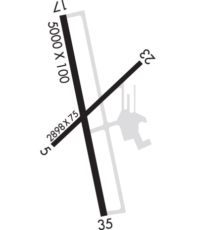
Runway Identifications
Runway Identification: 05/23Length: 2898 ft
Width: 75 ft
Surface: ASPHALT-GOOD CONDITION
Edge lights: Treatment: NONE
| | Runway: 05 | | Runway: 23 |
| Mag heading: | 46° | Mag heading: | 226° |
| Rwy Slope: | .14% Up | Rwy Slope: | -.14% Down |
| Approach: | | Approach: | |
| Pattern: | Left Traffic | Pattern: | Left Traffic |
| Markings: | NONPRECISION INSTRUMENT | Markings: | NONPRECISION INSTRUMENT |
| Marking Condition: | GOOD | Marking Condition: | GOOD |
| Arresting Dev: | | Arresting Dev: | |
| Lat & Long: | N4340.7 W09322.3 | Lat. & Long.: | N4341.1 W09321.8 |
| Elev: | 1252.8 ft. MSL | Elev: | 1256.9 ft. MSL |
| TCH: | | TCH: | |
| Visual Glide Path: | | Visual Glide Path: | |
| Displaced Threshold: | No | Displaced Threshold: | No |
| Touchdown Zone: | YES | Touchdown Zone: | YES |
| Touchdown Elev.: | 1256.9 feet | Touchdown Elev.: | 1256.9 feet |
| Visual Glide Slope: | | Visual Glide Slope: | |
| RVR Equipment: | | RVR Equipment: | |
| RVV Equipment: | NO | RVV Equipment: | NO |
| Approach Lights: | | Approach Lights: | |
| REIL: | NO | REIL: | NO |
| Centerline Lights: | NO | Centerline Lights: | NO |
| Touchdown lights: | NO | Touchdown lights: | NO |
| Runway Category: | Runway with a Visual Approach | Runway Category: | Runway with a Visual Approach |
| Declared Distances: | | Declared Distances: | |
| Comments: | RWY 05 HAS 5 FT BRUSH 79 FT FM THE RWY END AND 79 FT RIGHT. | Comments: | |
Runway Identification: 17/35Length: 5000 ft
Width: 100 ft
Surface: ASPHALT-GOOD CONDITION
Edge lights: Medium IntensityTreatment: NONE
| | Runway: 17 | | Runway: 35 |
| Mag heading: | 167° | Mag heading: | 347° |
| Rwy Slope: | .02% Up | Rwy Slope: | -.02% Down |
| Approach: | | Approach: | |
| Pattern: | Left Traffic | Pattern: | Left Traffic |
| Markings: | NONPRECISION INSTRUMENT | Markings: | NONPRECISION INSTRUMENT |
| Marking Condition: | GOOD | Marking Condition: | GOOD |
| Arresting Dev: | | Arresting Dev: | |
| Lat & Long: | N4341.3 W09322.2 | Lat. & Long.: | N4340.5 W09322.0 |
| Elev: | 1260.0 ft. MSL | Elev: | 1261.0 ft. MSL |
| TCH: | 30 ft. AGL | TCH: | 30 ft. AGL |
| Visual Glide Path: | 3.00 degrees | Visual Glide Path: | 3.00 degrees |
| Displaced Threshold: | No | Displaced Threshold: | No |
| Touchdown Zone: | YES | Touchdown Zone: | YES |
| Touchdown Elev.: | 1260.0 feet | Touchdown Elev.: | 1261.0 feet |
| Visual Glide Slope: | 4-Light PAPI on LEFT side of Runway | Visual Glide Slope: | 4-Light PAPI on LEFT side of Runway |
| RVR Equipment: | | RVR Equipment: | |
| RVV Equipment: | NO | RVV Equipment: | NO |
| Approach Lights: | ODALS - omnidirectional approach lighting system | Approach Lights: | |
| REIL: | YES | REIL: | YES |
| Centerline Lights: | NO | Centerline Lights: | NO |
| Touchdown lights: | NO | Touchdown lights: | NO |
| Runway Category: | D | Runway Category: | D |
| Declared Distances: | | Declared Distances: | |
| Obstructions: | | Obstructions: | ROAD |
| Marked: | | Marked: | NOT Marked/Lighted |
| Clearance slope: | 34:1 | Clearance slope: | 18:1 |
| Obstruction height: | | Obstruction height: | 7 feet AGL |
| Dist. from runway: | | Dist. from runway: | 332 feet |
| Centerline offset: | | Centerline offset: | 499 feet right of centerline |
| Comments: | | Comments: | |

