
| |||||||||||||||||||||||||||||||||||||||||||||||||||||||||||||||||||||
| |||||||||||||||||||||||||||||||||||||||||||||||||||||||||||||||||||||
| |||||||||||||||||||||||||||||||||||||||||||||||||||||||||||||||||||||
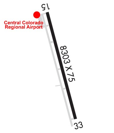
| Rwy | Rwy | |||||||
| 8303x75 | 8303' | 8303x75 | 8303' | |||||
| Runway ID | Single Wheel | Double Wheel | Double Tandem Wheel | Dual Double Wheel |
| 15/33 | 30,000 | 30,000 | N/A | N/A |
| These numbers are Advisory and are not limits. The Airport Manager should have more accurate Weight Limits | ||||
 Airport Diagram might not be current. | |
| Facility Name: | CENTRAL COLORADO RGNL |
| City Name: | BUENA VISTA |
| County: | CHAFFEE |
| State abbrev: | CO |
| State Name: | COLORADO |
| Ownership: | PUBLICLY OWNED |
| Use: | OPEN TO THE PUBLIC |
| Owner's Name: | TOWN OF BUENA VISTA |
| Address: | BOX 2002 |
| BUENA VISTA, CO 81211 | |
| Owner's Phone: | 719-395-8643 |
| Manager's Name: | JACK WYLES |
| Address: | 27960 COUNTY ROAD 319 |
| BUENA VISTA, CO 81211 | |
| Phone: | 719-395-3496; ALTERNATE PHONE 719-966-9098 |
| FAA Region: | NORTHWEST MOUNTAIN |
| FAA Field Office: | DEN |
| Date | Sunrise | Sunset |
|---|---|---|
| 04/17/24 Wednesday | 6:24 | 19:44 |
| 04/18/24 Thursday | 6:23 | 19:45 |
| 04/19/24 Friday | 6:21 | 19:46 |
| 04/20/24 Saturday | 6:20 | 19:47 |
| 04/21/24 Sunday | 6:19 | 19:48 |
| 04/22/24 Monday | 6:17 | 19:49 |
| 04/23/24 Tuesday | 6:16 | 19:50 |
| 04/24/24 Wednesday | 6:15 | 19:51 |
| 04/25/24 Thursday | 6:13 | 19:52 |
| 04/26/24 Friday | 6:12 | 19:53 |
| 04/27/24 Saturday | 6:11 | 19:54 |
| 04/28/24 Sunday | 6:09 | 19:55 |
| 04/29/24 Monday | 6:08 | 19:56 |
| 04/30/24 Tuesday | 6:07 | 19:57 |
| Airport Attendance Schedule | MON-FRI 0800-1600; FOR SVC AFTER HRS CALL 719-395-3496. |
| Airport Status | OPERATIONAL (This Status can change at any time - please check NOTAMS) |
| Airport Lighting Schedule | ACTVT MIRL RY 15/33 & PAPI RYS 15 & 33 - CTAF. |
| Airport Storage Available | Tie Downs, Hanger |
| Extra Services Available | Flight Instruction |
| Wind Indicator | YES - (lighted) |
| Control Tower | NO |
| CTAF Frequency | 122.800 |
| Unicom Frequency | 122.800 |
| Rotating Beacon Color | WG |
| Segmented Circle | YES |
| Landing Fee | NO |
| Airport Inspected | STATE - performed by STATE AERONAUTICAL PERSONNEL |
| Inspection Date | 07/28/2021 |
| Type of Fuel Available | Grade 100LL, JET A (freeze point -40C) |
| Airframe Repair Service | MINOR |
| Power Plant Repair Service | MINOR |
| Latitude | N3848.9 |
| Longitude | W10607.2 (ESTIMATED) |
| Arpt Elevation | 7950ft (SURVEYED) |
| Magnetic Variation | 11E |
| 2 miles S | of BUENA VISTA |
| Traffic Pattern Altitude | |
| Sectional Chart | DENVER |
| Operations (Reported) | Yearly | Avg. Daily |
|---|---|---|
| General Aviation Transient | 5970 | 16 |
| General Aviation Local | 3893 | 11 |
| Air Taxi | 0 | 0 |
| Commerical | 0 | 0 |
| Commuter | 0 | 0 |
| Military | 137 | 0 |
| Aircraft based on Field | |
|---|---|
| General Aviation Singles | 19 |
| General Aviation Multi | 0 |
| Jet Aircraft | 0 |
| General Aviation Helicopters | 0 |
| Military Aircraft | 0 |
| Gliders | 0 |
| Ultralights | 0 |
| FSS on field | NO |
| FSS tie-in | DENVER |
| FSS Phone | 1-800-WX-BRIEF |
| Who issues Notams | DEN |
| Notam D service at airport | YES |
| ARTCC Name | DENVER |
| Airport Certification | |
| Aircraft Rescue & Firefighting Index | None |
| Airport of Entry | No |
| Custom Landing Rights | No |
| Joint Civil/Military | No |
| Military Landing rights | No |
| NATIONAL PLAN OF INTEGRATED AIRPORT SYSTEMS (NPIAS) |
| GRANT AGREEMENTS UNDER FAAP/ADAP/AIP |
| ASSURANCES PURSUANT TO TITLE VI, CIVIL RIGHTS ACT OF 1964 |
| ALL TWYS MKD WITH BLUE/YELLOW REFLECTORS. |
| DEER ON & INVOF ARPT. |
| -3 FT DRAINAGE DITCH 170 FT E OF RY 15/33 CNTRLN, FULL LENGTH. |
| RY 15 HAS +25 FT TREE 765 FT FM THLD 275 R OF CNTRLN. |
| COLD TEMPERATURE AIRPORT. ALTITUDE CORRECTION REQUIRED AT OR BELOW -22C. |
| FOR CD CTC DENVER ARTCC AT 303-651-4257. |
Airport Communications & Frequencies:
| |||||||||
| Runway: 15 | Runway: 33 | ||
| Mag heading: | 150° | Mag heading: | 330° |
| Rwy Slope: | -.56% Down | Rwy Slope: | .56% Up |
| Approach: | Approach: | ||
| Pattern: | Right Traffic | Pattern: | Left Traffic |
| Markings: | NONPRECISION INSTRUMENT | Markings: | NONPRECISION INSTRUMENT |
| Marking Condition: | GOOD | Marking Condition: | GOOD |
| Arresting Dev: | Arresting Dev: | ||
| Lat & Long: | N3849.5 W10607.5 | Lat. & Long.: | N3848.2 W10607.0 |
| Elev: | 7950.4 ft. MSL | Elev: | 7904.0 ft. MSL |
| TCH: | 42 ft. AGL | TCH: | 41 ft. AGL |
| Visual Glide Path: | 3.00 degrees | Visual Glide Path: | 3.00 degrees |
| Displaced Threshold: | No | Displaced Threshold: | No |
| Touchdown Zone: | YES | Touchdown Zone: | YES |
| Touchdown Elev.: | 7950.4 feet | Touchdown Elev.: | 7926.3 feet |
| Visual Glide Slope: | 2-Light PAPI on LEFT side of Runway | Visual Glide Slope: | 2-Light PAPI on LEFT side of Runway; PAPI UNUSE BYD 9 DEG LEFT OF COURSE. |
| RVR Equipment: | RVR Equipment: | ||
| RVV Equipment: | NO | RVV Equipment: | NO |
| Approach Lights: | Approach Lights: | ||
| REIL: | NO | REIL: | NO |
| Centerline Lights: | NO | Centerline Lights: | NO |
| Touchdown lights: | NO | Touchdown lights: | NO |
| Runway Category: | Runway with a Visual Approach | Runway Category: | Runway with a Non-precision Approach having visibility minimums greater than 3/4 mile |
| Declared Distances: | Declared Distances: | ||
| Obstructions: | TREE | Obstructions: | |
| Marked: | NOT Marked/Lighted | Marked: | |
| Clearance slope: | 21:1 | Clearance slope: | 50:1 |
| Obstruction height: | 23 feet AGL | Obstruction height: | |
| Dist. from runway: | 705 feet | Dist. from runway: | |
| Centerline offset: | 295 right of centerline | Centerline offset: | |
| Comments: | Comments: |


