Current Weather/Notams (Metars, TAFs, Notams, NWS Forecast, PIREPS, and nearby weather)
Customs Information Send updates to Support@FltPlan.com
Customs Not Available
Database effective 05/16/2024
Airport Diagram might not be current.
|
| Facility Name: | AUDUBON COUNTY |
| City Name: | AUDUBON |
| County: | AUDUBON |
| State abbrev: | IA |
| State Name: | IOWA |
| | |
| Ownership: | PUBLICLY OWNED |
| Use: | OPEN TO THE PUBLIC |
| Owner's Name: | AUDUBON COUNTY ARPT AUTH; LOU HERBERS CHAIRMAN OFFICE# 712-563-4440. |
| Address: | P.O. BOX 1 |
| | AUDUBON, IA 50025 |
| Owner's Phone: | (712) 563-4440 |
| | |
| Manager's Name: | LOU HERBERS |
| Address: | 2110 HIGHWAY 71 |
| | AUDUBON, IA 50025 |
| Phone: | (712) 563-4440 |
| | |
| FAA Region: | CENTRAL |
| FAA Field Office: | NONE |
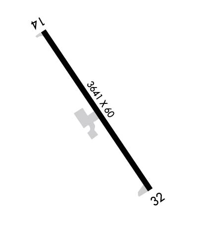
Runway Identifications
Runway Identification: 14/32Length: 3641 ft
Width: 60 ft
Surface: CONCRETE-GOOD CONDITION
Edge lights: Medium IntensityTreatment: NONE
| | Runway: 14 | | Runway: 32 |
| Mag heading: | 143° | Mag heading: | 323° |
| Rwy Slope: | -.29% Down | Rwy Slope: | .29% Up |
| Approach: | | Approach: | |
| Pattern: | Left Traffic | Pattern: | Left Traffic |
| Markings: | NONPRECISION INSTRUMENT | Markings: | NONPRECISION INSTRUMENT |
| Marking Condition: | GOOD | Marking Condition: | GOOD |
| Arresting Dev: | | Arresting Dev: | |
| Lat & Long: | N4142.3 W09455.4 | Lat. & Long.: | N4141.8 W09455.0 |
| Elev: | 1287.7 ft. MSL | Elev: | 1277.2 ft. MSL |
| TCH: | 40 ft. AGL | TCH: | 40 ft. AGL |
| Visual Glide Path: | 3.00 degrees | Visual Glide Path: | 3.25 degrees |
| Displaced Threshold: | 140 feet | Displaced Threshold: | No |
| Touchdown Zone: | YES | Touchdown Zone: | YES |
| Touchdown Elev.: | 1287.5 feet | Touchdown Elev.: | 1286.0 feet |
| Visual Glide Slope: | 2-Light PAPI on LEFT side of Runway | Visual Glide Slope: | 2-Light PAPI on LEFT side of Runway |
| RVR Equipment: | | RVR Equipment: | |
| RVV Equipment: | NO | RVV Equipment: | NO |
| Approach Lights: | | Approach Lights: | |
| REIL: | YES | REIL: | YES |
| Centerline Lights: | NO | Centerline Lights: | NO |
| Touchdown lights: | NO | Touchdown lights: | NO |
| Runway Category: | Runway with a Visual Approach | Runway Category: | Runway with a Non-precision Approach |
| Declared Distances: | | Declared Distances: | |
| Obstructions: | TREE | Obstructions: | BRDG |
| Marked: | NOT Marked/Lighted | Marked: | NOT Marked/Lighted |
| Clearance slope: | 24:1; RWY 14 APCH SLOPE 32:1 TO DSPLCD THLD. | Clearance slope: | 20:1 |
| Obstruction height: | 43 feet AGL | Obstruction height: | 20 feet AGL |
| Dist. from runway: | 1241 feet | Dist. from runway: | 613 feet |
| Centerline offset: | 39 left of centerline | Centerline offset: | 208 feet left of centerline |
| Comments: | | Comments: | |

