Current Weather/Notams (Metars, TAFs, Notams, NWS Forecast, PIREPS, and nearby weather)
Customs Information Send updates to Support@FltPlan.com
Customs Not Available
Database effective 04/18/2024
Airport Diagram might not be current.
|
| Facility Name: | ATWOOD-RAWLINS COUNTY CITY-COUNTY |
| City Name: | ATWOOD |
| County: | RAWLINS |
| State abbrev: | KS |
| State Name: | KANSAS |
| | |
| Ownership: | PUBLICLY OWNED |
| Use: | OPEN TO THE PUBLIC |
| Owner's Name: | CITY OF ATWOOD & RAWLINS CO. |
| Address: | |
| | ATWOOD, KS 67730 |
| Owner's Phone: | 785-626-3344 |
| | |
| Manager's Name: | CHRIS TIEMEYER |
| Address: | 12323 HWY 25 |
| | ATWOOD, KS 67730 |
| Phone: | (785) 626-0297 |
| | |
| FAA Region: | CENTRAL |
| FAA Field Office: | NONE |
Runway Identifications
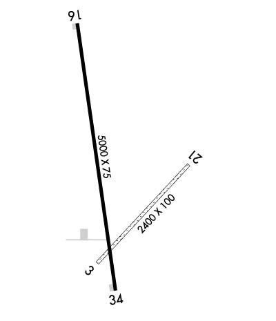
Runway Identification: 04/22Length: 2400 ft
Width: 100 ft
Surface: GRASS-GOOD CONDITION
Edge lights: Treatment: NONE
| | Runway: 04 | | Runway: 22 |
| Mag heading: | 40° | Mag heading: | 220° |
| Rwy Slope: | .70% Up | Rwy Slope: | -.70% Down |
| Approach: | | Approach: | |
| Pattern: | Left Traffic | Pattern: | Left Traffic |
| Markings: | NONE | Markings: | NONE |
| Marking Condition: | FAIR | Marking Condition: | FAIR |
| Arresting Dev: | | Arresting Dev: | |
| Lat & Long: | N3950.1 W10102.6 | Lat. & Long.: | N3950.4 W10102.3 |
| Elev: | 2929.5 ft. MSL | Elev: | 2946.3 ft. MSL |
| TCH: | | TCH: | |
| Visual Glide Path: | | Visual Glide Path: | |
| Displaced Threshold: | No | Displaced Threshold: | No |
| Touchdown Zone: | YES | Touchdown Zone: | YES |
| Touchdown Elev.: | 2946.3 feet | Touchdown Elev.: | 2946.3 feet |
| Visual Glide Slope: | | Visual Glide Slope: | |
| RVR Equipment: | | RVR Equipment: | |
| RVV Equipment: | NO | RVV Equipment: | NO |
| Approach Lights: | | Approach Lights: | |
| REIL: | NO | REIL: | NO |
| Centerline Lights: | NO | Centerline Lights: | NO |
| Touchdown lights: | NO | Touchdown lights: | NO |
| Runway Category: | Runway with a Visual Approach | Runway Category: | Runway with a Visual Approach |
| Declared Distances: | | Declared Distances: | |
| Obstructions: | PLINE | Obstructions: | |
| Marked: | MARKED | Marked: | |
| Clearance slope: | 33:1 | Clearance slope: | 50:1 |
| Obstruction height: | 28 feet AGL | Obstruction height: | |
| Dist. from runway: | 950 feet | Dist. from runway: | |
| Centerline offset: | | Centerline offset: | |
| Comments: | | Comments: | |
Runway Identification: 17/35Length: 5000 ft
Width: 75 ft
Surface: ASPHALT-GOOD CONDITION
Edge lights: Medium IntensityTreatment: NONE
| | Runway: 17 | | Runway: 35 |
| Mag heading: | 167° | Mag heading: | 347° |
| Rwy Slope: | -1.28% Down | Rwy Slope: | 1.28% Up |
| Approach: | | Approach: | |
| Pattern: | Left Traffic | Pattern: | Left Traffic |
| Markings: | NONPRECISION INSTRUMENT | Markings: | NONPRECISION INSTRUMENT |
| Marking Condition: | GOOD | Marking Condition: | GOOD |
| Arresting Dev: | | Arresting Dev: | |
| Lat & Long: | N3950.9 W10102.7 | Lat. & Long.: | N3950.1 W10102.5 |
| Elev: | 2990.7 ft. MSL | Elev: | 2926.7 ft. MSL |
| TCH: | 40 ft. AGL | TCH: | 40 ft. AGL |
| Visual Glide Path: | 3.00 degrees | Visual Glide Path: | 3.00 degrees |
| Displaced Threshold: | No | Displaced Threshold: | No |
| Touchdown Zone: | YES | Touchdown Zone: | YES |
| Touchdown Elev.: | 2990.7 feet | Touchdown Elev.: | 2963.7 feet |
| Visual Glide Slope: | 2-Light PAPI on LEFT side of Runway | Visual Glide Slope: | 2-Light PAPI on RIGHT side of Runway |
| RVR Equipment: | | RVR Equipment: | |
| RVV Equipment: | NO | RVV Equipment: | NO |
| Approach Lights: | | Approach Lights: | |
| REIL: | YES | REIL: | YES |
| Centerline Lights: | NO | Centerline Lights: | NO |
| Touchdown lights: | NO | Touchdown lights: | NO |
| Runway Category: | Runway with a Non-precision Approach having visibility minimums greater than 3/4 mile | Runway Category: | Runway with a Visual Approach |
| Declared Distances: | | Declared Distances: | |

