Current Weather/Notams (Metars, TAFs, Notams, NWS Forecast, PIREPS, and nearby weather)
Customs Information Send updates to Support@FltPlan.com
Customs Not Available
Database effective 05/16/2024
Airport Diagram might not be current.
|
| Facility Name: | ARDMORE MUNI |
| City Name: | ARDMORE |
| County: | CARTER |
| State abbrev: | OK |
| State Name: | OKLAHOMA |
| | |
| Ownership: | PUBLICLY OWNED |
| Use: | OPEN TO THE PUBLIC |
| Owner's Name: | CITY OF ARDMORE; ARPT OPERD BY ARDMORE DVLPMT AUTH 580-389-5238. |
| Address: | 23 S. WASHINGTON |
| | ARDMORE, OK 73401 |
| Owner's Phone: | 580-226-2100 |
| | |
| Manager's Name: | DAN LUTTRELL |
| Address: | 620 GENERAL DR., SUITE 1 |
| | ARDMORE, OK 73401 |
| Phone: | 580-389-5238 |
| | |
| FAA Region: | SOUTHWEST |
| FAA Field Office: | AOK |
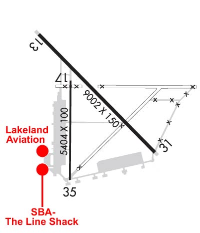
Runway Identifications
Runway Identification: 13/31Length: 9002 ft
Width: 150 ft
Surface: CONCRETE-GOOD CONDITION
Edge lights: High IntensityTreatment: NONE
| | Runway: 13 | | Runway: 31 |
| Mag heading: | 129° | Mag heading: | 309° |
| Rwy Slope: | -.53% Down | Rwy Slope: | .53% Up |
| Approach: | | Approach: | ILS |
| Pattern: | Left Traffic | Pattern: | Left Traffic |
| Markings: | PRECISION INSTRUMENT | Markings: | PRECISION INSTRUMENT |
| Marking Condition: | FAIR | Marking Condition: | FAIR |
| Arresting Dev: | | Arresting Dev: | |
| Lat & Long: | N3418.9 W09701.8 | Lat. & Long.: | N3417.8 W09700.5 |
| Elev: | 776.7 ft. MSL | Elev: | 728.9 ft. MSL |
| TCH: | 57 ft. AGL | TCH: | 49 ft. AGL |
| Visual Glide Path: | 3.00 degrees | Visual Glide Path: | 3.00 degrees |
| Displaced Threshold: | No | Displaced Threshold: | No |
| Touchdown Zone: | YES | Touchdown Zone: | YES |
| Touchdown Elev.: | 776.7 feet | Touchdown Elev.: | 732.9 feet |
| Visual Glide Slope: | 4-Light PAPI on LEFT side of Runway | Visual Glide Slope: | 4-BOX VASI ON LEFT SIDE OF RUNWAY |
| RVR Equipment: | | RVR Equipment: | |
| RVV Equipment: | NO | RVV Equipment: | NO |
| Approach Lights: | | Approach Lights: | MALSR - 1,400 foot medium intensity approach lighting system with runway alignment indicator lights |
| REIL: | NO | REIL: | NO |
| Centerline Lights: | NO | Centerline Lights: | NO |
| Touchdown lights: | NO | Touchdown lights: | NO |
| Runway Category: | Runway with a Non-precision Approach having visibility minimums greater than 3/4 mile | Runway Category: | Precision Instrument Runway |
| Declared Distances: | | Declared Distances: | |
| Obstructions: | TREES | Obstructions: | TREES |
| Marked: | NOT Marked/Lighted | Marked: | NOT Marked/Lighted |
| Clearance slope: | 25:1 | Clearance slope: | 27:1 |
| Obstruction height: | 72 feet AGL | Obstruction height: | 68 feet AGL |
| Dist. from runway: | 2000 feet | Dist. from runway: | 2075 feet |
| Centerline offset: | 660 left of centerline | Centerline offset: | 366 feet left of centerline |
| Comments: | | Comments: | |
Runway Identification: 17/35Length: 5404 ft
Width: 100 ft
Surface: ASPHALT-GOOD CONDITION
Edge lights: Medium IntensityTreatment: NONE
| | Runway: 17 | | Runway: 35 |
| Mag heading: | 174° | Mag heading: | 354° |
| Rwy Slope: | -.49% Down | Rwy Slope: | .49% Up |
| Approach: | | Approach: | |
| Pattern: | Left Traffic | Pattern: | Left Traffic |
| Markings: | BASIC | Markings: | BASIC |
| Marking Condition: | GOOD | Marking Condition: | GOOD |
| Arresting Dev: | | Arresting Dev: | |
| Lat & Long: | N3418.5 W09701.4 | Lat. & Long.: | N3417.6 W09701.4 |
| Elev: | 751.1 ft. MSL | Elev: | 724.7 ft. MSL |
| TCH: | | TCH: | |
| Visual Glide Path: | | Visual Glide Path: | |
| Displaced Threshold: | No | Displaced Threshold: | 397 feet |
| Touchdown Zone: | YES | Touchdown Zone: | YES |
| Touchdown Elev.: | 751.1 feet | Touchdown Elev.: | 725.4 feet |
| Visual Glide Slope: | | Visual Glide Slope: | |
| RVR Equipment: | | RVR Equipment: | |
| RVV Equipment: | NO | RVV Equipment: | NO |
| Approach Lights: | | Approach Lights: | |
| REIL: | NO | REIL: | NO |
| Centerline Lights: | NO | Centerline Lights: | NO |
| Touchdown lights: | NO | Touchdown lights: | NO |
| Runway Category: | Runway with a Visual Approach | Runway Category: | Runway with a Visual Approach |
| Declared Distances: | TORA:5007' TODA:5007' ASDA:5007' LDA:5007' | Declared Distances: | TORA:5404' TODA:5404' ASDA:5404' LDA:5007' |