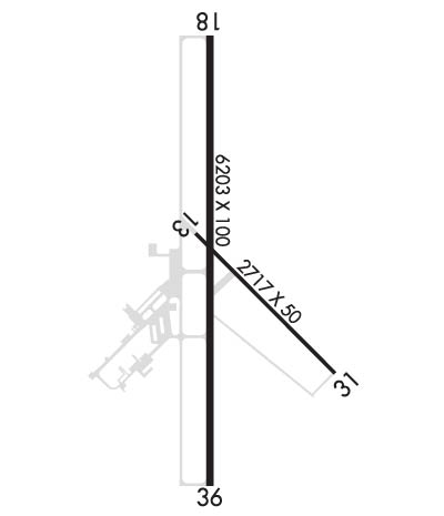
Click here for more info on on SMS!

KADH

ADA MUNI
ADA
OK
Time Zone: Central
Lat: N 3448.3
Long: W 09640.3
Elev: 1016
Var: -03
Longest Runway: 6203
AWOS: 118.72
CTAF: 122.8

FBO & Flight Services info for KADH

FBOs: Update your Fuel Prices

HEARTLAND AVIATPh: 580-235-5279 Fax: 580-421-9906 Freq: 122.8
Service
Jet
100LL
SAF
MoGas
Fuel Avail: PRIST+ $0.05/gal . Volume Discounts Available. 24 hour service
Full5.006.00    Caution: Fuel prices have not been updated in 42 days.
Last Update: 03/08/2024 13:16

Self        
 Address: 2800 RAY STOUT BLVD   ADA, OK 74820
AWOSPh: 580-332-6222
-
Freq: 118.72  
If you are an FBO, call 1-203-262-1700 to update your info or email: FltPlan.Advertising@garmin.com
Advertise your FBO on FltPlan.com

Runway & Approach Info for KADH
Rwy
Length
Land Dist**
Approach*
  Rwy
Length
Land Dist**
Approach*
13
2717x50  2717'          
 
  
31
  2717x50  2717'          
 
18
6203x100  6203'          
 
  
36
  6203x100  6103'          
 
 * only ILS, LOC, LDA, and SDF approaches to a specific runway are shown
** For any Declared Landing Distance Available, please see A/FD or Approach plates
Runway Weight Capability (lbs.) Help
Runway IDSingle WheelDouble WheelDouble Tandem WheelDual Double Wheel
13/3150,000171,000280,000N/A
18/3650,000140,000224,000N/A
H1N/AN/AN/AN/A
These numbers are Advisory and are not limits.   The Airport Manager should have more accurate Weight Limits
Approach Charts
Approaches    
Current Weather/Notams
Customs Information Send updates to Support@FltPlan.com
Customs Not Available
Database effective 04/18/2024
Airport Diagram of KADH
Airport Diagram might not be current.

Facility Name: ADA RGNL
City Name: ADA
County: PONTOTOC
State abbrev: OK
State Name: OKLAHOMA
   
Ownership: PUBLICLY OWNED
Use: OPEN TO THE PUBLIC
Owner's Name: CITY OF ADA
Address: 231 S TOWNSEND, 512 N. STOCKTON
 ADA, OK 74820
Owner's Phone: 580-436-6300
  
Manager's Name: CHRIS SOMERS
Address: 300 RAY STOUT BLVD, SUITE A
 ADA, OK 74820
Phone: 580-436-8190
   
FAA Region: SOUTHWEST
FAA Field Office: AOK


Sunrise / Sunset times for ADA RGNL

DateSunriseSunset
04/18/24 Thursday6:5020:02
04/19/24 Friday6:4920:03
04/20/24 Saturday6:4820:04
04/21/24 Sunday6:4720:04
04/22/24 Monday6:4520:05
04/23/24 Tuesday6:4420:06
04/24/24 Wednesday6:4320:07
04/25/24 Thursday6:4220:08
04/26/24 Friday6:4120:08
04/27/24 Saturday6:4020:09
04/28/24 Sunday6:3920:10
04/29/24 Monday6:3720:11
04/30/24 Tuesday6:3620:12
05/01/24 Wednesday6:3520:12

Airport Facilities

Airport Attendance ScheduleMON-SAT 0800-1700, SUN 1200-1700
Airport Status OPERATIONAL (This Status can change at any time - please check NOTAMS)
Airport Lighting ScheduleACTVT ODALS RWY 18; REILS RWY 36; MIRL RWY 18/36 - CTAF. PAPI RWY 18 & 36 ON CONSLY.
Airport Storage AvailableTie Downs, Hanger
Extra Services AvailableAir Ambulance, Aircraft Rental, Annual Surveying
Wind IndicatorYES - (lighted)
Control TowerNO
CTAF Frequency122.800
Unicom Frequency122.800
Rotating Beacon ColorWG
Segmented CircleYES
Landing FeeYES; LNDG FEE FOR ACFT 50000 LBS OR GTR.

Airport Inspection Data

Airport InspectedSTATE - performed by STATE AERONAUTICAL PERSONNEL
Inspection Date09/22/2023

Airport Services

Type of Fuel AvailableGrade 100LL, JET A; -10AFT HR FUEL - 580-235-5279.
Airframe Repair ServiceMAJOR
Power Plant Repair ServiceMAJOR

Geographic Data

LatitudeN3448.3
LongitudeW09640.3 (ESTIMATED)
Arpt Elevation1015ft (SURVEYED)
Magnetic Variation03E
2 miles Nof ADA
Traffic Pattern Altitude
Sectional ChartDALLAS-FT WORTH

Aircraft Data

Operations (Reported)YearlyAvg. Daily
General Aviation Transient 820022
General Aviation Local 410011
Air Taxi 00
Commerical 00
Commuter 00
Military 1000
Aircraft based on Field
General Aviation Singles 42
General Aviation Multi 5
Jet Aircraft 2
General Aviation Helicopters 2
Military Aircraft 0
Gliders 0
Ultralights 0

FAA Services

FSS on field NO
FSS tie-in MC ALESTER
FSS Phone 1-800-WX-BRIEF
Who issues Notams ADH
Notam D service at airport YES
ARTCC Name FORT WORTH

Federal Status

Airport Certification
Aircraft Rescue & Firefighting IndexNone
Airport of EntryNo
Custom Landing RightsNo
Joint Civil/MilitaryNo
Military Landing rightsYES

Federal Agreements

NATIONAL PLAN OF INTEGRATED AIRPORT SYSTEMS (NPIAS)
GRANT AGREEMENTS UNDER FAAP/ADAP/AIP
ASSURANCES PURSUANT TO TITLE VI, CIVIL RIGHTS ACT OF 1964
AGREEMENT UNDER DLAND OR DCLA HAS EXPIRED.

Remarks

FOR CD CTC FORT WORTH ARTCC AT 817-858-7584.
RWY 13/3 1 SVR CRACKING & RAVELING ASPH PTN.
Airport Communications & Frequencies:
CTAF Frequency:
122.800
Unicom Frequency:
122.800
Remarks
  • APCH/DEP CTL SVC PRVDD BY FORT WORTH ARTCC (ZFW) ON FREQS 132.2/338.35 (MC ALESTER RCAG).
  • Runway Identifications
    Runway Identification: 13/31
    Length: 2717 ft
    Width: 50 ft
    Surface: CONCRETE ASPHALT-POOR CONDITION
    Edge lights:

    Treatment: NONE

     Runway: 13   Runway: 31
    Mag heading: 132°Mag heading: 312°
    Rwy Slope: -.93% DownRwy Slope: .93% Up
    Approach: Approach:
    Pattern: Left TrafficPattern: Left Traffic
    Markings: BASICMarkings: BASIC
    Marking Condition: POOR; MARKINGS SVRLY FADED.Marking Condition: POOR; MARKINGS SVRLY FADED.
    Arresting Dev: Arresting Dev:
    Lat & Long: N3448.3  W09640.4Lat. & Long.: N3448.0  W09640.0
    Elev: 1004.0 ft. MSLElev: 978.6 ft. MSL
    TCH: TCH:
    Visual Glide Path: Visual Glide Path:
    Displaced Threshold: NoDisplaced Threshold: No
    Touchdown Zone: YESTouchdown Zone: YES
    Touchdown Elev.: 1004.0 feetTouchdown Elev.: 1004.0 feet
    Visual Glide Slope: Visual Glide Slope:
    RVR Equipment: RVR Equipment:
    RVV Equipment: NORVV Equipment: NO
    Approach Lights: Approach Lights:
    REIL: NOREIL: NO
    Centerline Lights: NOCenterline Lights: NO
    Touchdown lights: NOTouchdown lights: NO
    Runway Category: Runway with a Visual ApproachRunway Category: Runway with a Visual Approach
    Declared Distances: Declared Distances:
    Runway Identification: 18/36
    Length: 6203 ft
    Width: 100 ft
    Surface: ASPHALT-FAIR CONDITION
    Edge lights: Medium Intensity

    Treatment: NONE

     Runway: 18   Runway: 36
    Mag heading: 177°Mag heading: 357°
    Rwy Slope: -.59% DownRwy Slope: .59% Up
    Approach: Approach:
    Pattern: Left TrafficPattern: Left Traffic
    Markings: NONPRECISION INSTRUMENTMarkings: NONPRECISION INSTRUMENT
    Marking Condition: GOODMarking Condition: GOOD
    Arresting Dev: Arresting Dev:
    Lat & Long: N3448.8  W09640.3Lat. & Long.: N3447.8  W09640.3
    Elev: 1015.9 ft. MSLElev: 979.4 ft. MSL
    TCH: 31 ft. AGLTCH: 43 ft. AGL
    Visual Glide Path: 3.00 degreesVisual Glide Path: 3.00 degrees
    Displaced Threshold: NoDisplaced Threshold: 100 feet
    Touchdown Zone: YESTouchdown Zone: YES
    Touchdown Elev.: 1015.9 feetTouchdown Elev.: 995.1 feet
    Visual Glide Slope: 4-Light PAPI on LEFT side of RunwayVisual Glide Slope: 4-Light PAPI on LEFT side of Runway; UNUSBL BYD 7 DEGS RIGHT OF CNTRLN.
    RVR Equipment: RVR Equipment:
    RVV Equipment: NORVV Equipment: NO
    Approach Lights: ODALS - omnidirectional approach lighting systemApproach Lights:
    REIL: NOREIL: YES
    Centerline Lights: NOCenterline Lights: NO
    Touchdown lights: NOTouchdown lights: NO
    Runway Category: Runway with a Non-precision Approach having visibility minimums greater than 3/4 mileRunway Category: Runway with a Non-precision Approach having visibility minimums greater than 3/4 mile
    Declared Distances: Declared Distances:
    Obstructions: TREESObstructions: TREES
    Marked: NOT Marked/LightedMarked: NOT Marked/Lighted
    Clearance slope: 27:1; CLNC SLP TO DISP THLD 22:1.Clearance slope: 16:1
    Obstruction height: 31 feet AGLObstruction height: 62 feet AGL
    Dist. from runway: 1039 feetDist. from runway: 1249 feet
    Centerline offset: 54 left of centerlineCenterline offset: 335 feet left of centerline
    Comments: Comments:
    Runway Identification: H1 HELIPAD
    Length: 40 ft
    Width: 40 ft
    Surface: CONCRETE
    Edge lights: PERI

    Treatment: NONE

    C:8/P: