
| ||||||||||||||||||||||||||||||||||||||||||||
| ||||||||||||||||||||||||||||||||||||||||||||
| ||||||||||||||||||||||||||||||||||||||||||||
| Rwy | Rwy | |||||||
| 5003x100 | 5003' | 5003x100 | 5003' | |||||
| Runway ID | Single Wheel | Double Wheel | Double Tandem Wheel | Dual Double Wheel |
| 02/20 | 38,000 | 55,000 | N/A | N/A |
| These numbers are Advisory and are not limits. The Airport Manager should have more accurate Weight Limits | ||||
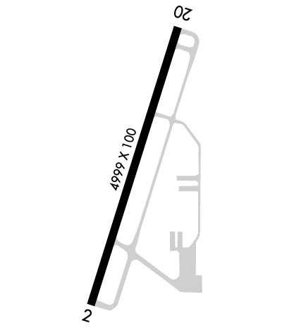 Airport Diagram might not be current. | |
| Facility Name: | ANTRIM COUNTY |
| City Name: | BELLAIRE |
| County: | ANTRIM |
| State abbrev: | MI |
| State Name: | MICHIGAN |
| Ownership: | PUBLICLY OWNED |
| Use: | OPEN TO THE PUBLIC |
| Owner's Name: | ANTRIM COUNTY |
| Address: | PO BOX 520, 230 E CAYUGA ST |
| BELLAIRE, MI 49615-0520 | |
| Owner's Phone: | 231-533-6353 |
| Manager's Name: | MATTHEW WYMAN |
| Address: | 3366A S DERENZY RD |
| BELLAIRE, MI 49615-9499 | |
| Phone: | 231-533-8524; CELL 231-622-1926. |
| FAA Region: | GREAT LAKES |
| FAA Field Office: | DET |

| Date | Sunrise | Sunset |
|---|---|---|
| 04/18/24 Thursday | 6:50 | 20:31 |
| 04/19/24 Friday | 6:48 | 20:32 |
| 04/20/24 Saturday | 6:46 | 20:34 |
| 04/21/24 Sunday | 6:45 | 20:35 |
| 04/22/24 Monday | 6:43 | 20:36 |
| 04/23/24 Tuesday | 6:41 | 20:37 |
| 04/24/24 Wednesday | 6:40 | 20:39 |
| 04/25/24 Thursday | 6:38 | 20:40 |
| 04/26/24 Friday | 6:37 | 20:41 |
| 04/27/24 Saturday | 6:35 | 20:42 |
| 04/28/24 Sunday | 6:33 | 20:44 |
| 04/29/24 Monday | 6:32 | 20:45 |
| 04/30/24 Tuesday | 6:30 | 20:46 |
| 05/01/24 Wednesday | 6:29 | 20:47 |
| Airport Attendance Schedule | 7 Days A Week 0700-1700; UNATNDD MAJOR HOLS. |
| Airport Status | OPERATIONAL (This Status can change at any time - please check NOTAMS) |
| Airport Lighting Schedule | ACTVT OR INCR INTST REIL RWY 02 & 20; PAPI RWY 02 & 20; MIRL RWY 02/20 - CTAF. MIRL RWY 02/20 PRESET LOW INTST. |
| Airport Storage Available | Tie Downs, Hanger |
| Extra Services Available | NONE |
| Wind Indicator | YES - (lighted) |
| Control Tower | NO |
| CTAF Frequency | 122.700 |
| Unicom Frequency | 122.700 |
| Rotating Beacon Color | WG |
| Segmented Circle | YES |
| Landing Fee | YES; LDG FEE APPLIES TO TURBINE & JET ENG ACFT; WAIVED WITH MNM FUEL PURCHASE. |
| Airport Inspected | 5010-1 PUBLIC USE MAILOUT PROGRAM - performed by STATE AERONAUTICAL PERSONNEL |
| Inspection Date | 04/06/2023 |
| Type of Fuel Available | Grade 100LL, JET A; -10FOR FUEL AFT HRS CALL 231-350-8145. |
| Airframe Repair Service | None |
| Power Plant Repair Service | None |
| Latitude | N4459.3 |
| Longitude | W08511.9 (ESTIMATED) |
| Arpt Elevation | 623ft (SURVEYED) |
| Magnetic Variation | 05W |
| 1 miles NE | of BELLAIRE |
| Traffic Pattern Altitude | |
| Sectional Chart | GREEN BAY |
| Operations (Reported) | Yearly | Avg. Daily |
|---|---|---|
| General Aviation Transient | 3638 | 10 |
| General Aviation Local | 3638 | 10 |
| Air Taxi | 0 | 0 |
| Commerical | 0 | 0 |
| Commuter | 0 | 0 |
| Military | 0 | 0 |
| Aircraft based on Field | |
|---|---|
| General Aviation Singles | 21 |
| General Aviation Multi | 3 |
| Jet Aircraft | 0 |
| General Aviation Helicopters | 0 |
| Military Aircraft | 0 |
| Gliders | 0 |
| Ultralights | 0 |
| FSS on field | NO |
| FSS tie-in | LANSING |
| FSS Phone | 1-800-WX-BRIEF |
| Who issues Notams | ACB |
| Notam D service at airport | YES |
| ARTCC Name | MINNEAPOLIS |
| Airport Certification | |
| Aircraft Rescue & Firefighting Index | None |
| Airport of Entry | No |
| Custom Landing Rights | No |
| Joint Civil/Military | No |
| Military Landing rights | YES |
| NATIONAL PLAN OF INTEGRATED AIRPORT SYSTEMS (NPIAS) |
| GRANT AGREEMENTS UNDER FAAP/ADAP/AIP |
| ASSURANCES PURSUANT TO TITLE VI, CIVIL RIGHTS ACT OF 1964 |
| LRG BIRDS ON & INVOF ARPT. |
| SNOW REMOVAL EQPT ON RWY & TWYS DURG WINTER MONTHS. |
| FOR CD CTC MINNEAPOLIS ARTCC AT 651-463-5588. |
Airport Communications & Frequencies:
| |||||||||
| Runway: 02 | Runway: 20 | ||
| Mag heading: | 22° | Mag heading: | 202° |
| Rwy Slope: | -.08% Down | Rwy Slope: | .08% Up |
| Approach: | Approach: | ||
| Pattern: | Left Traffic | Pattern: | Left Traffic |
| Markings: | NONPRECISION INSTRUMENT | Markings: | NONPRECISION INSTRUMENT |
| Marking Condition: | GOOD | Marking Condition: | GOOD |
| Arresting Dev: | Arresting Dev: | ||
| Lat & Long: | N4458.9 W08512.1 | Lat. & Long.: | N4459.7 W08511.7 |
| Elev: | 621.6 ft. MSL | Elev: | 617.5 ft. MSL |
| TCH: | 45 ft. AGL | TCH: | 45 ft. AGL |
| Visual Glide Path: | 3.00 degrees | Visual Glide Path: | 3.25 degrees |
| Displaced Threshold: | No | Displaced Threshold: | No |
| Touchdown Zone: | YES | Touchdown Zone: | YES |
| Touchdown Elev.: | 623.0 feet | Touchdown Elev.: | 622.2 feet |
| Visual Glide Slope: | 4-Light PAPI on LEFT side of Runway | Visual Glide Slope: | 2-Light PAPI on LEFT side of Runway |
| RVR Equipment: | RVR Equipment: | ||
| RVV Equipment: | NO | RVV Equipment: | NO |
| Approach Lights: | Approach Lights: | ||
| REIL: | YES | REIL: | YES |
| Centerline Lights: | NO | Centerline Lights: | NO |
| Touchdown lights: | NO | Touchdown lights: | NO |
| Runway Category: | Runway with a Non-precision Approach having visibility minimums greater than 3/4 mile | Runway Category: | Runway with a Visual Approach |
| Declared Distances: | Declared Distances: | ||
| Obstructions: | TREE | Obstructions: | |
| Marked: | NOT Marked/Lighted | Marked: | |
| Clearance slope: | 23:1 | Clearance slope: | 20:1 |
| Obstruction height: | 62 feet AGL | Obstruction height: | |
| Dist. from runway: | 1667 feet | Dist. from runway: | |
| Centerline offset: | 112 right of centerline | Centerline offset: | |
| Comments: | Comments: |