KABR

ABERDEEN RGNL
ABERDEEN
SD
Time Zone: Central
Lat: N 4526.8
Long: W 09825.3
Elev: 1302
Var: -07
Longest Runway: 6901
AWOS: 125.87
CTAF: 122.7

FBO & Flight Services info for KABR

FBOs: Update your Fuel Prices

  click here  
Providing high quality fuel and services to you and your customers, from Phillips 66 Aviation. CAA Preferred FBO
Ph: 605-225-1384 Fax: 605-225-1570 Freq: 122.77WebsiteE-Mail
                   
Service
Jet
100LL
SAF
MoGas
Fuel Avail: ~~ PILOTS CALL FOR BULK FUEL PRICES
Full6.356.45    Last Update: 04/19/2024 00:01:45
PRICES GUARANTEED by FBO.
Self        
Misc. Info: Only Deicing service provider on the field
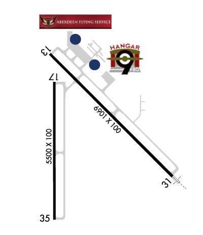
Address: 4430 EAST HIGHWAY 12,   ABERDEEN, SD 57401
Hangar 9 is a Fixed Base Operator in Aberdeen, SD offering friendly self-serve and full-service fuel, flight instruction, charter flights, and maintenance. You'll find a comfortable and clean atmosphre and probably fresh-baked cookies too!
Ph: 605-725-4774 Fax: 605-725-4776 Freq: 131.62WebsiteE-Mail
                     
Service
Jet
100LL
SAF
MoGas
Fuel Avail: Full service 8AM-5PM daily with 24/7 self serve 100LL.CAA PREFERRED FBO!
Full6.006.50    Caution: Fuel prices have not been updated in 52 days.
Last Update: 02/28/2024 11:06

Price includes ALL taxes and fees
Self  6.20    
Misc. Info: CAA Preferred FBO!Address: 4740 6TH AVE SOUTHEAST STE 19   ABERDEEN, SD 57401

QUEST AVIATIONPh: 605-225-8008 Fax: 605-225-0115 Freq: 122.85
Service
Jet
100LL
SAF
MoGas
Fuel Avail: PRIST $0.07/gal. M-F 6a - 8p, SS 7a - 5p; $75 Aftr Hrs Fee
Full6.656.95    Last Update: 04/06/2024 12:35  
Self        
 Address: 4440 E HWY 12,   ABERDEEN, SD 57401
AWOSPh: 605-229-4512
-
Freq: 125.87  
If you are an FBO, call 1-203-262-1700 to update your info or email: FltPlan.Advertising@garmin.com
Advertise your FBO on FltPlan.com
FBOs at nearby airports who want your business:
KFSD


  click here  
Maverick Air Center at KFSD

- Open 24/7
- No Ramp Fees, No Security Fees, No Handling Fees, No Additive Fees!
- Providing Excellent Service at competitive rates
- Quick Turns
- Jet A & 100LL
- Walk-up rental vehicles
- Large hangar space, able to accomodate a G550

www.maverickaircenter.com
Ph: 1-605-312-5680WebsiteE-MailFax: 1-605-271-6387Freq: 122.77

Runway & Approach Info for KABR
Rwy
Length
Land Dist**
Approach*
  Rwy
Length
Land Dist**
Approach*
13
6901x100  6901'          
 
  
31
  6901x100  6901'          
ILS/DME
 109.90 - 308°  
17
5500x100  5500'          
 
  
35
  5500x100  5500'          
 
 * only ILS, LOC, LDA, and SDF approaches to a specific runway are shown
** For any Declared Landing Distance Available, please see A/FD or Approach plates
Runway Weight Capability (lbs.) Help
Runway IDSingle WheelDouble WheelDouble Tandem WheelDual Double Wheel
13/31120,000195,000339,000N/A
17/3563,00082,000139,000N/A
These numbers are Advisory and are not limits.   The Airport Manager should have more accurate Weight Limits
Approach Charts
Approaches    
Current Weather/Notams
Customs Information Send updates to Support@FltPlan.com
Customs Not Available
Database effective 04/18/2024
Airport Diagram of KABR
Airport Diagram might not be current.

Facility Name: ABERDEEN RGNL
City Name: ABERDEEN
County: BROWN
State abbrev: SD
State Name: SOUTH DAKOTA
   
Ownership: PUBLICLY OWNED
Use: OPEN TO THE PUBLIC
Owner's Name: CITY OF ABERDEEN
Address: 123 S LINCOLN ST
 ABERDEEN, SD 57401-1420
Owner's Phone: 605-626-7020
  
Manager's Name: RICH KROKEL
Address: 4740 6TH AVENUE SE
 ABERDEEN, SD 57401-4215
Phone: 605-626-7020
   
FAA Region: GREAT LAKES
FAA Field Office: DMA


Sunrise / Sunset times for ABERDEEN RGNL

DateSunriseSunset
04/19/24 Friday6:4020:26
04/20/24 Saturday6:3820:27
04/21/24 Sunday6:3720:29
04/22/24 Monday6:3520:30
04/23/24 Tuesday6:3320:31
04/24/24 Wednesday6:3220:32
04/25/24 Thursday6:3020:34
04/26/24 Friday6:2820:35
04/27/24 Saturday6:2720:36
04/28/24 Sunday6:2520:38
04/29/24 Monday6:2420:39
04/30/24 Tuesday6:2220:40
05/01/24 Wednesday6:2120:41
05/02/24 Thursday6:1920:43

Airport Facilities

Airport Attendance ScheduleMON-FRI 0330-2400L; FOR SVCS AFTER HRS CALL (605) 225-1384/8008 OR (605)725-4774
Airport Status OPERATIONAL (This Status can change at any time - please check NOTAMS)
Airport Lighting ScheduleMIRL RWY 17/35 & HIRL RWY 13/31 PRESET ON LOW INTST SS-2400; TO INCR INTST & ACTVT MALSR RWY 31; REIL RWYS 13, 17, & 35; AND PAPI RWY 13 - CTAF.
Airport Storage AvailableHanger
Extra Services AvailableAir Freight, Crop Dusting, Air Ambulance, Charter, Flight Instruction, Aircraft Rental, Aircraft Sales
Wind IndicatorYES - (lighted)
Control TowerNO
CTAF Frequency122.700
Unicom Frequency122.700
Rotating Beacon ColorWG
Segmented CircleYES
Landing FeeNO

Airport Inspection Data

Airport InspectedFEDERAL - performed by FAA AIRPORTS FIELD PERSONNEL
Inspection Date06/01/2023

Airport Services

Type of Fuel AvailableGrade 100LL, JET A (freeze point -40C)
Airframe Repair ServiceMAJOR
Power Plant Repair ServiceMAJOR

Geographic Data

LatitudeN4526.8
LongitudeW09825.3 (ESTIMATED)
Arpt Elevation1301ft (SURVEYED)
Magnetic Variation07E
2 miles Eof ABERDEEN
Traffic Pattern Altitude
Sectional ChartTWIN CITIES

Aircraft Data

Operations (Reported)YearlyAvg. Daily
General Aviation Transient 2600071
General Aviation Local 720020
Air Taxi 500014
Commerical 14864
Commuter 00
Military 600
Aircraft based on Field
General Aviation Singles 42
General Aviation Multi 16
Jet Aircraft 7
General Aviation Helicopters 1
Military Aircraft 0
Gliders 0
Ultralights 0

FAA Services

FSS on field NO
FSS tie-in HURON
FSS Phone 1-800-WX-BRIEF
Who issues Notams ABR
Notam D service at airport YES
ARTCC Name MINNEAPOLIS

Federal Status

Airport CertificationAIRPORT RECEIVING SCHEDULED AIR CARRIER SERVICE FROM CARRIERS CERTIFICATED BY THE CIVIL AERONAUTICS BOARD; PPR FOR UNSKED ACR OPNS WITH MORE THAN 30 PSGR SEATS CALL AMGR 605-626-7020. AFT HRS CALL 605-216-0321.
Aircraft Rescue & Firefighting IndexAIRPORT HAS A CERTIFICATE UNDER CFR PART 139
Airport of EntryNo
Custom Landing RightsNo
Joint Civil/MilitaryNo
Military Landing rightsYES

Federal Agreements

NATIONAL PLAN OF INTEGRATED AIRPORT SYSTEMS (NPIAS)
GRANT AGREEMENTS UNDER FAAP/ADAP/AIP
ASSURANCES PURSUANT TO TITLE VI, CIVIL RIGHTS ACT OF 1964

Remarks

BIRDS ON & INVOF ARPT.
ARPT NOT AVBL FOR INTL ARRIVALS.
SURFACE CONDITIONS NOT MONITORED 0000-0330L
FOR CD IF UNA TO CTC ON FSS FREQ, CTC MINNEAPOLIS ARTCC AT 651-463-5588.
Airport Communications & Frequencies:
CTAF Frequency:
122.700
Unicom Frequency:
122.700
Remarks
  • APCH/DEP SVC PRVDD BY MINNEAPOLIS ARTCC ON FREQS 120.6/371.9 (ABERDEEN RCAG).
  • Runway Identifications
    Runway Identification: 13/31
    Length: 6901 ft
    Width: 100 ft
    Surface: CONCRETE-GOOD CONDITION
    Edge lights: High Intensity

    Treatment: GROOVED
    Weight: PCN 56 /R/B/W/T

     Runway: 13   Runway: 31
    Mag heading: 128°Mag heading: 308°
    Rwy Slope: -.01% DownRwy Slope: .01% Up
    Approach: Approach: ILS/DME
    Pattern: Left TrafficPattern: Left Traffic
    Markings: PRECISION INSTRUMENTMarkings: PRECISION INSTRUMENT
    Marking Condition: GOODMarking Condition: GOOD
    Arresting Dev: Arresting Dev:
    Lat & Long: N4527.3  W09825.7Lat. & Long.: N4526.5  W09824.5
    Elev: 1301.9 ft. MSLElev: 1300.9 ft. MSL
    TCH: 50 ft. AGLTCH: 67 ft. AGL
    Visual Glide Path: 3.00 degreesVisual Glide Path: 3.00 degrees
    Displaced Threshold: NoDisplaced Threshold: No
    Touchdown Zone: YESTouchdown Zone: YES
    Touchdown Elev.: 1301.9 feetTouchdown Elev.: 1300.9 feet
    Visual Glide Slope: 4-Light PAPI on LEFT side of RunwayVisual Glide Slope: 4-Light PAPI on LEFT side of Runway
    RVR Equipment: RVR Equipment:
    RVV Equipment: NORVV Equipment: NO
    Approach Lights: Approach Lights: MALSR - 1,400 foot medium intensity approach lighting system with runway alignment indicator lights
    REIL: YESREIL: NO
    Centerline Lights: NOCenterline Lights: NO
    Touchdown lights: NOTouchdown lights: NO
    Runway Category: DRunway Category: Precision Instrument Runway
    Declared Distances: TORA:6901' TODA:6901' ASDA:6901' LDA:6901'Declared Distances: TORA:6901' TODA:6901' ASDA:6901' LDA:6901'
    Runway Identification: 17/35
    Length: 5500 ft
    Width: 100 ft
    Surface: ASPHALT
    Edge lights: Medium Intensity

    Treatment: GROOVED
    Weight: PCN 25 /F/D/X/T

     Runway: 17   Runway: 35
    Mag heading: 173°Mag heading: 353°
    Rwy Slope: -.03% DownRwy Slope: .03% Up
    Approach: Approach:
    Pattern: Left TrafficPattern: Left Traffic
    Markings: PRECISION INSTRUMENTMarkings: PRECISION INSTRUMENT
    Marking Condition: GOODMarking Condition: GOOD
    Arresting Dev: Arresting Dev:
    Lat & Long: N4527.1  W09825.6Lat. & Long.: N4526.2  W09825.6
    Elev: 1301.8 ft. MSLElev: 1300.3 ft. MSL
    TCH: 40 ft. AGLTCH: 40 ft. AGL
    Visual Glide Path: 3.00 degreesVisual Glide Path: 3.00 degrees
    Displaced Threshold: NoDisplaced Threshold: No
    Touchdown Zone: YESTouchdown Zone: YES
    Touchdown Elev.: 1301.8 feetTouchdown Elev.: 1300.3 feet
    Visual Glide Slope: 4-Light PAPI on RIGHT side of RunwayVisual Glide Slope: 4-Light PAPI on LEFT side of Runway
    RVR Equipment: RVR Equipment:
    RVV Equipment: NORVV Equipment: NO
    Approach Lights: Approach Lights:
    REIL: YESREIL: YES
    Centerline Lights: NOCenterline Lights: NO
    Touchdown lights: NOTouchdown lights: NO
    Runway Category: DRunway Category: D
    Declared Distances: TORA:5500' TODA:5500' ASDA:5500' LDA:5500'Declared Distances: TORA:5500' TODA:5500' ASDA:5500' LDA:5500'
    C:52/P: