KABI

ABILENE RGNL
ABILENE
TX
Time Zone: Central
Lat: N 3224.7
Long: W 09940.9
Elev: 1791
Var: -05
Longest Runway: 7208
Dept. ATIS: 118.25
Arr. ATIS: 118.25
Ground: 121.7
Tower: 120.1

FBO & Flight Services info for KABI

FBOs: Update your Fuel Prices

ABILENE AEROPh: 325-677-2601 Fax: 325-671-8017 Freq: 122.95
Service
Jet
100LL
SAF
MoGas
Fuel Avail: PRIST PREMIXED 24 Hours. Quantity Discounts on Jet Fuel Purchases. Call to Get Todays Pricing
Full6.597.19    Last Update: 04/08/2024 09:39

Self  6.19    
 Address: 2850 AIRPORT BLVD   ABILENE, TX 79602
ASOSPh: 325-676-3524
-
-
 
ATISPh: 325-677-1597
-
-
 
If you are an FBO, call 1-203-262-1700 to update your info or email: FltPlan.Advertising@garmin.com
Advertise your FBO on FltPlan.com

Runway & Approach Info for KABI
Rwy
Length
Land Dist**
Approach*
  Rwy
Length
Land Dist**
Approach*
17L
7198x150  7198'          
 
  
35R
  7198x150  7198'          
ILS/DME
 110.30 - 354°  
17R
7208x150  7208'          
LOC/DME
 109.75 - 174°  
  
35L
  7208x150  7208'          
 
 * only ILS, LOC, LDA, and SDF approaches to a specific runway are shown
** For any Declared Landing Distance Available, please see A/FD or Approach plates
Runway Weight Capability (lbs.) Help
Runway IDSingle WheelDouble WheelDouble Tandem WheelDual Double Wheel
17L/35R85,000160,000160,000N/A
17R/35L85,000160,000160,000N/A
These numbers are Advisory and are not limits.   The Airport Manager should have more accurate Weight Limits
Approach Charts
Approaches    
Current Weather/Notams
Customs Information Send updates to Support@FltPlan.com
Customs Not Available
Database effective 05/16/2024
Airport Diagram of KABI
Airport Diagram might not be current.

Facility Name: ABILENE RGNL
City Name: ABILENE
County: TAYLOR
State abbrev: TX
State Name: TEXAS
   
Ownership: PUBLICLY OWNED
Use: OPEN TO THE PUBLIC
Owner's Name: CITY OF ABILENE
Address: PO BOX 60
 ABILENE, TX 79604
Owner's Phone: 325-676-6206
  
Manager's Name: DON GREEN
Address: 2933 AIRPORT BLVD SUITE 200
 ABILENE, TX 79602
Phone: 325-676-6367
   
FAA Region: SOUTHWEST
FAA Field Office: TEX


Sunrise / Sunset times for ABILENE RGNL

DateSunriseSunset
04/24/24 Wednesday6:5820:15
04/25/24 Thursday6:5720:16
04/26/24 Friday6:5620:17
04/27/24 Saturday6:5520:18
04/28/24 Sunday6:5420:18
04/29/24 Monday6:5320:19
04/30/24 Tuesday6:5220:20
05/01/24 Wednesday6:5120:21
05/02/24 Thursday6:5020:21
05/03/24 Friday6:5020:22
05/04/24 Saturday6:4920:23
05/05/24 Sunday6:4820:23
05/06/24 Monday6:4720:24
05/07/24 Tuesday6:4620:25

Airport Facilities

Airport Attendance ScheduleCONTINUOUS
Airport Status OPERATIONAL (This Status can change at any time - please check NOTAMS)
Airport Lighting ScheduleSS-SR
Airport Storage AvailableTie Downs, Hanger
Extra Services AvailableAir Freight, Avionics, Charter, Aircraft Sales
Wind IndicatorYES - (lighted)
Control TowerYES
CTAF Frequency
Unicom Frequency122.950
Rotating Beacon ColorWG
Segmented CircleYES
Landing FeeNO

Airport Inspection Data

Airport InspectedFEDERAL - performed by FAA AIRPORTS FIELD PERSONNEL
Inspection Date06/08/2023

Airport Services

Type of Fuel AvailableGrade 100LL, JET A (freeze point -40C), JET A-1 (icing inhibitor, freeze point -50C)
Airframe Repair ServiceMAJOR
Power Plant Repair ServiceMAJOR

Geographic Data

LatitudeN3224.7
LongitudeW09940.9 (ESTIMATED)
Arpt Elevation1790ft (SURVEYED)
Magnetic Variation05E
3 miles SEof ABILENE
Traffic Pattern Altitude
Sectional ChartDALLAS-FT WORTH

Aircraft Data

Operations (Reported)YearlyAvg. Daily
General Aviation Transient 1477340
General Aviation Local 733520
Air Taxi 581716
Commerical 13894
Commuter 00
Military 1214533
Aircraft based on Field
General Aviation Singles 79
General Aviation Multi 17
Jet Aircraft 8
General Aviation Helicopters 1
Military Aircraft 0
Gliders 0
Ultralights 0

FAA Services

FSS on field NO
FSS tie-in FORT WORTH
FSS Phone 1-800-WX-BRIEF
Who issues Notams ABI
Notam D service at airport YES
ARTCC Name FORT WORTH

Federal Status

Airport CertificationAIRPORT RECEIVING SCHEDULED AIR CARRIER SERVICE FROM CARRIERS CERTIFICATED BY THE CIVIL AERONAUTICS BOARD; ABI IS ARFF INDEX B; ARFF INDEX C AVBL WITH PPR.
Aircraft Rescue & Firefighting IndexAIRPORT HAS A CERTIFICATE UNDER CFR PART 139
Airport of EntryNo
Custom Landing RightsNo
Joint Civil/MilitaryNo
Military Landing rightsYES

Federal Agreements

NATIONAL PLAN OF INTEGRATED AIRPORT SYSTEMS (NPIAS)
GRANT AGREEMENTS UNDER FAAP/ADAP/AIP
ASSURANCES PURSUANT TO TITLE VI, CIVIL RIGHTS ACT OF 1964

Remarks

UNCTLD ARPT 2 NM NE OF ARPT, PAT ALT 2300 FT.
MIL AVN SVCS AVBL AT ARPT.
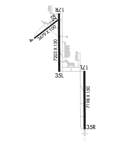
RWY 04/22 PERMLY CLSD, NOT AVBL FOR ACFT OPNS.
Airport Communications & Frequencies:
ATIS Frequencies:   Hours(local) of Operation: CONTINUOUS
118.25
ABILENE Tower Frequencies:   Hours(local) of operation: CONTINUOUS   
120.1
257.8
ABILENE Ground Frequencies:
121.7
348.6
Emergency Frequencies:
121.5
243.0
Unicom Frequency:
122.950
ABILENE Primary Approach Frequencies:   Hours(local) of operation: CONTINUOUS   
125.0 ;EAST
127.2 ;WEST
282.3 ;WEST
338.3 ;EAST
ABILENE Primary Departure Frequencies:   Hours(local) of operation: CONTINUOUS   
125.0 ;EAST
127.2 ;WEST
282.3 ;WEST
338.3 ;EAST
Class C Frequencies:
125.0 ;EAST
127.2 ;WEST
282.3 ;WEST
338.3 ;EAST
Runway Identifications
Runway Identification: 17L/35R
Length: 7198 ft
Width: 150 ft
Surface: ASPHALT-GOOD CONDITION
Edge lights: High Intensity

Treatment: GROOVED
Weight: PCN 57 /F/C/X/T

 Runway: 17L   Runway: 35R
Mag heading: 175°Mag heading: 355°
Rwy Slope: -.20% DownRwy Slope: .20% Up
Approach: Approach: ILS/DME
Pattern: Left TrafficPattern: Right Traffic
Markings: PRECISION INSTRUMENTMarkings: PRECISION INSTRUMENT
Marking Condition: GOODMarking Condition: GOOD
Arresting Dev: Arresting Dev:
Lat & Long: N3224.5  W09940.5Lat. & Long.: N3223.3  W09940.5
Elev: 1790.6 ft. MSLElev: 1775.9 ft. MSL
TCH: 54 ft. AGLTCH:
Visual Glide Path: 3.00 degreesVisual Glide Path:
Displaced Threshold: NoDisplaced Threshold: No
Touchdown Zone: YESTouchdown Zone: YES
Touchdown Elev.: 1790.6 feetTouchdown Elev.: 1776.4 feet
Visual Glide Slope: 4-Light PAPI on LEFT side of RunwayVisual Glide Slope:
RVR Equipment: ROLLOUTRVR Equipment: TOUCHDOWN
RVV Equipment: NORVV Equipment: NO
Approach Lights: Approach Lights: MALSR - 1,400 foot medium intensity approach lighting system with runway alignment indicator lights
REIL: NOREIL: NO
Centerline Lights: NOCenterline Lights: NO
Touchdown lights: NOTouchdown lights: NO
Runway Category: Runway with a Non-precision Approach having visibility minimums greater than 3/4 mileRunway Category: Precision Instrument Runway
Declared Distances: TORA:7198' TODA:7198' ASDA:7198' LDA:7198'Declared Distances: TORA:7198' TODA:7198' ASDA:7198' LDA:7198'
Obstructions: GNDObstructions:
Marked: NOT Marked/LightedMarked:
Clearance slope: Clearance slope: 50:1
Obstruction height: 2 feet AGLObstruction height:
Dist. from runway: 200 feetDist. from runway:
Centerline offset: Centerline offset:
Comments: Comments:
Runway Identification: 17R/35L
Length: 7208 ft
Width: 150 ft
Surface: ASPHALT-GOOD CONDITION
Edge lights: High Intensity

Treatment: GROOVED
Weight: PCN 61 /F/D/X/T

 Runway: 17R   Runway: 35L
Mag heading: 175°Mag heading: 355°
Rwy Slope: .38% UpRwy Slope: -.38% Down
Approach: LOC/DMEApproach:
Pattern: Right TrafficPattern: Left Traffic
Markings: NONPRECISION INSTRUMENTMarkings: NONPRECISION INSTRUMENT
Marking Condition: GOODMarking Condition: GOOD
Arresting Dev: Arresting Dev:
Lat & Long: N3225.7  W09941.1Lat. & Long.: N3224.5  W09941.1
Elev: 1758.4 ft. MSLElev: 1786.1 ft. MSL
TCH: 63 ft. AGLTCH: 54 ft. AGL
Visual Glide Path: 3.00 degreesVisual Glide Path: 3.00 degrees
Displaced Threshold: NoDisplaced Threshold: No
Touchdown Zone: YESTouchdown Zone: YES
Touchdown Elev.: 1771.2 feetTouchdown Elev.: 1786.2 feet
Visual Glide Slope: 4-Light PAPI on LEFT side of RunwayVisual Glide Slope: 4-Light PAPI on LEFT side of Runway
RVR Equipment: RVR Equipment:
RVV Equipment: NORVV Equipment: NO
Approach Lights: Approach Lights:
REIL: NOREIL: YES
Centerline Lights: NOCenterline Lights: NO
Touchdown lights: NOTouchdown lights: NO
Runway Category: Runway with a Non-precision Approach having visibility minimums greater than 3/4 mileRunway Category: Runway with a Visual Approach
Declared Distances: TORA:7202' TODA:7202' ASDA:7202' LDA:7202'Declared Distances: TORA:7202' TODA:7202' ASDA:7202' LDA:7202'
C:58/P: