Current Weather/Notams (Metars, TAFs, Notams, NWS Forecast, PIREPS, and nearby weather)
Customs Information Send updates to Support@FltPlan.com
Customs Not Available
Database effective 05/16/2024
Airport Diagram might not be current.
|
| Facility Name: | APALACHICOLA RGNL-CLEVE RANDOLPH FLD |
| City Name: | APALACHICOLA |
| County: | FRANKLIN |
| State abbrev: | FL |
| State Name: | FLORIDA |
| | |
| Ownership: | PUBLICLY OWNED |
| Use: | OPEN TO THE PUBLIC |
| Owner's Name: | FRANKLIN COUNTY |
| Address: | 33 MARKET STREET, SUITE 203 |
| | APALACHICOLA, FL 32320-2317 |
| Owner's Phone: | 850-653-9783 |
| | |
| Manager's Name: | TED MOSTELLER |
| Address: | 8 AIRPORT ROAD |
| | APALACHICOLA, FL 32320-2317 |
| Phone: | 850-653-5115 |
| | |
| FAA Region: | SOUTHERN |
| FAA Field Office: | ORL |
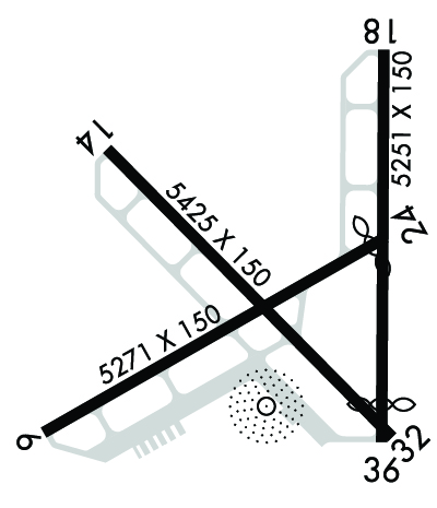
Runway Identifications
Runway Identification: 06/24Length: 5271 ft
Width: 150 ft
Surface: CONCRETE-FAIR CONDITION
Edge lights: Medium IntensityTreatment: NONE
Weight: PCN 12 /R/B/X/T
| | Runway: 06 | | Runway: 24 |
| Mag heading: | 63° | Mag heading: | 243° |
| Rwy Slope: | .00% Down | Rwy Slope: | .00% Up |
| Approach: | | Approach: | |
| Pattern: | Left Traffic | Pattern: | Left Traffic |
| Markings: | NONPRECISION INSTRUMENT | Markings: | NONPRECISION INSTRUMENT |
| Marking Condition: | GOOD | Marking Condition: | GOOD |
| Arresting Dev: | | Arresting Dev: | |
| Lat & Long: | N2943.3 W08502.2 | Lat. & Long.: | N2943.8 W08501.4 |
| Elev: | 19.4 ft. MSL | Elev: | 19.3 ft. MSL |
| TCH: | 40 ft. AGL | TCH: | 40 ft. AGL |
| Visual Glide Path: | 3.00 degrees | Visual Glide Path: | 3.00 degrees |
| Displaced Threshold: | No | Displaced Threshold: | 217 feet |
| Touchdown Zone: | YES | Touchdown Zone: | YES |
| Touchdown Elev.: | 19.5 feet | Touchdown Elev.: | 19.5 feet |
| Visual Glide Slope: | 2-Light PAPI on LEFT side of Runway | Visual Glide Slope: | 2-Light PAPI on LEFT side of Runway |
| RVR Equipment: | | RVR Equipment: | |
| RVV Equipment: | NO | RVV Equipment: | NO |
| Approach Lights: | | Approach Lights: | |
| REIL: | NO | REIL: | NO |
| Centerline Lights: | NO | Centerline Lights: | NO |
| Touchdown lights: | NO | Touchdown lights: | NO |
| Runway Category: | Runway with a Non-precision Approach having visibility minimums greater than 3/4 mile | Runway Category: | Runway with a Non-precision Approach having visibility minimums greater than 3/4 mile |
| Declared Distances: | | Declared Distances: | |
| Obstructions: | TREES | Obstructions: | TREES |
| Marked: | NOT Marked/Lighted | Marked: | NOT Marked/Lighted |
| Clearance slope: | 20:1 | Clearance slope: | 16:1 |
| Obstruction height: | 59 feet AGL | Obstruction height: | 47 feet AGL |
| Dist. from runway: | 1390 feet | Dist. from runway: | 985 feet |
| Centerline offset: | 175 right of centerline | Centerline offset: | 130 feet left of centerline |
| Comments: | | Comments: | |
Runway Identification: 14/32Length: 5425 ft
Width: 150 ft
Surface: CONCRETE-FAIR CONDITION
Edge lights: Medium IntensityTreatment: NONE
Weight: PCN 12 /R/B/X/T
| | Runway: 14 | | Runway: 32 |
| Mag heading: | 138° | Mag heading: | 318° |
| Rwy Slope: | .06% Up | Rwy Slope: | -.06% Down |
| Approach: | | Approach: | |
| Pattern: | Left Traffic | Pattern: | Left Traffic |
| Markings: | NONPRECISION INSTRUMENT | Markings: | NONPRECISION INSTRUMENT |
| Marking Condition: | GOOD | Marking Condition: | GOOD |
| Arresting Dev: | | Arresting Dev: | |
| Lat & Long: | N2944.0 W08502.1 | Lat. & Long.: | N2943.3 W08501.4 |
| Elev: | 15.1 ft. MSL | Elev: | 18.2 ft. MSL |
| TCH: | 40 ft. AGL | TCH: | 66 ft. AGL |
| Visual Glide Path: | 3.00 degrees | Visual Glide Path: | 3.00 degrees |
| Displaced Threshold: | No | Displaced Threshold: | No |
| Touchdown Zone: | YES | Touchdown Zone: | YES |
| Touchdown Elev.: | 19.5 feet | Touchdown Elev.: | 19.5 feet |
| Visual Glide Slope: | 2-Light PAPI on LEFT side of Runway | Visual Glide Slope: | 2-Light PAPI on LEFT side of Runway |
| RVR Equipment: | | RVR Equipment: | |
| RVV Equipment: | NO | RVV Equipment: | NO |
| Approach Lights: | | Approach Lights: | |
| REIL: | NO | REIL: | NO |
| Centerline Lights: | NO | Centerline Lights: | NO |
| Touchdown lights: | NO | Touchdown lights: | NO |
| Runway Category: | Runway with a Non-precision Approach having visibility minimums greater than 3/4 mile | Runway Category: | Runway with a Non-precision Approach having visibility minimums greater than 3/4 mile |
| Declared Distances: | | Declared Distances: | |
| Obstructions: | TREES | Obstructions: | BRUSH |
| Marked: | NOT Marked/Lighted | Marked: | NOT Marked/Lighted |
| Clearance slope: | 34:1; RWY 32 APCH RATIO 25:1 TO AER. | Clearance slope: | 7:1 |
| Obstruction height: | 23 feet AGL | Obstruction height: | 6 feet AGL |
| Dist. from runway: | 975 feet | Dist. from runway: | 240 feet |
| Centerline offset: | 20 right of centerline | Centerline offset: | 270 feet right of centerline |
| Comments: | | Comments: | |
Runway Identification: 18/36Length: 5251 ft
Width: 150 ft
Surface: CONCRETE-FAIR CONDITION
Edge lights: Treatment: NONE
Weight: PCN 12 /R/B/X/T
| | Runway: 18 | | Runway: 36 |
| Mag heading: | 183° | Mag heading: | 3° |
| Rwy Slope: | .08% Up | Rwy Slope: | -.08% Down |
| Approach: | | Approach: | |
| Pattern: | Left Traffic | Pattern: | Left Traffic |
| Markings: | BASIC | Markings: | BASIC |
| Marking Condition: | GOOD | Marking Condition: | GOOD |
| Arresting Dev: | | Arresting Dev: | |
| Lat & Long: | N2944.2 W08501.4 | Lat. & Long.: | N2943.3 W08501.4 |
| Elev: | 15.1 ft. MSL | Elev: | 19.5 ft. MSL |
| TCH: | | TCH: | |
| Visual Glide Path: | | Visual Glide Path: | |
| Displaced Threshold: | No | Displaced Threshold: | 502 feet |
| Touchdown Zone: | YES | Touchdown Zone: | YES |
| Touchdown Elev.: | 19.5 feet | Touchdown Elev.: | 19.5 feet |
| Visual Glide Slope: | | Visual Glide Slope: | |
| RVR Equipment: | | RVR Equipment: | |
| RVV Equipment: | NO | RVV Equipment: | NO |
| Approach Lights: | | Approach Lights: | |
| REIL: | NO | REIL: | NO |
| Centerline Lights: | NO | Centerline Lights: | NO |
| Touchdown lights: | NO | Touchdown lights: | NO |
| Runway Category: | Runway with a Visual Approach | Runway Category: | Runway with a Visual Approach |
| Declared Distances: | | Declared Distances: | |
| Obstructions: | TREES | Obstructions: | TREE |
| Marked: | NOT Marked/Lighted | Marked: | NOT Marked/Lighted |
| Clearance slope: | 14:1; RWY 18 APCH RATIO 17:1 TO AER. | Clearance slope: | 8:1; APCH RATIO 28:1 TO DTHR. |
| Obstruction height: | 71 feet AGL | Obstruction height: | 38 feet AGL |
| Dist. from runway: | 1205 feet | Dist. from runway: | 540 feet |
| Centerline offset: | 225 left of centerline | Centerline offset: | 190 feet left of centerline |
| Comments: | | Comments: | |

