
| ||||||||||||||||||||||||||||||||
| ||||||||||||||||||||||||||||||||
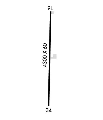
| Rwy | Rwy | |||||||
| 4300x60 | 4300' | 4300x60 | 4300' | |||||
| Runway ID | Single Wheel | Double Wheel | Double Tandem Wheel | Dual Double Wheel |
| 16/34 | 30,000 | N/A | N/A | N/A |
| These numbers are Advisory and are not limits. The Airport Manager should have more accurate Weight Limits | ||||
| FltPlan does not have IFR approach charts available for KA32. |
 Airport Diagram might not be current. | |
| Facility Name: | BUTTE VALLEY |
| City Name: | DORRIS |
| County: | SISKIYOU |
| State abbrev: | CA |
| State Name: | CALIFORNIA |
| Ownership: | PUBLICLY OWNED |
| Use: | OPEN TO THE PUBLIC |
| Owner's Name: | COUNTY OF SISKIYOU |
| Address: | 190 GREENHORN ROAD |
| YREKA, CA 96097 | |
| Owner's Phone: | 530-842-8297 |
| Manager's Name: | ANGIE STUMBAUGH; EMAIL: JLEDBETTER@CO.SISKIYOU.CA.US |
| Address: | 190 GREENHORN ROAD |
| YREKA, CA 96097 | |
| Phone: | 530-842-8297; AMGR OFC IN YREKA. |
| FAA Region: | WESTERN-PACIFIC |
| FAA Field Office: | SFO |
| Date | Sunrise | Sunset |
|---|---|---|
| 04/17/24 Wednesday | 6:23 | 19:52 |
| 04/18/24 Thursday | 6:22 | 19:53 |
| 04/19/24 Friday | 6:20 | 19:54 |
| 04/20/24 Saturday | 6:19 | 19:55 |
| 04/21/24 Sunday | 6:17 | 19:56 |
| 04/22/24 Monday | 6:16 | 19:58 |
| 04/23/24 Tuesday | 6:14 | 19:59 |
| 04/24/24 Wednesday | 6:13 | 20:00 |
| 04/25/24 Thursday | 6:11 | 20:01 |
| 04/26/24 Friday | 6:10 | 20:02 |
| 04/27/24 Saturday | 6:08 | 20:03 |
| 04/28/24 Sunday | 6:07 | 20:04 |
| 04/29/24 Monday | 6:06 | 20:05 |
| 04/30/24 Tuesday | 6:04 | 20:06 |
| Airport Attendance Schedule | UNATTENDED |
| Airport Status | OPERATIONAL (This Status can change at any time - please check NOTAMS) |
| Airport Lighting Schedule | ACTVT MIRL RY 16/34 KEY 122.9; 5 TIMES. |
| Airport Storage Available | Tie Downs |
| Extra Services Available | NONE |
| Wind Indicator | YES - (lighted) |
| Control Tower | NO |
| CTAF Frequency | 122.900 |
| Unicom Frequency | |
| Rotating Beacon Color | WG |
| Segmented Circle | YES |
| Landing Fee | NO |
| Airport Inspected | STATE - performed by STATE AERONAUTICAL PERSONNEL |
| Inspection Date | 09/16/2022 |
| Type of Fuel Available | None |
| Airframe Repair Service | NONE |
| Power Plant Repair Service | NONE |
| Latitude | N4153.2 |
| Longitude | W12158.5 (ESTIMATED) |
| Arpt Elevation | 4243ft (SURVEYED) |
| Magnetic Variation | 18E |
| 5 miles SW | of DORRIS |
| Traffic Pattern Altitude | 800 |
| Sectional Chart | KLAMATH FALLS |
| Operations (Reported) | Yearly | Avg. Daily |
|---|---|---|
| General Aviation Transient | 1000 | 3 |
| General Aviation Local | 50 | 0 |
| Air Taxi | 0 | 0 |
| Commerical | 0 | 0 |
| Commuter | 0 | 0 |
| Military | 0 | 0 |
| Aircraft based on Field | |
|---|---|
| General Aviation Singles | 1 |
| General Aviation Multi | 0 |
| Jet Aircraft | 0 |
| General Aviation Helicopters | 0 |
| Military Aircraft | 0 |
| Gliders | 0 |
| Ultralights | 0 |
| FSS on field | NO |
| FSS tie-in | RANCHO MURIETA |
| FSS Phone | 1-800-WX-BRIEF |
| Who issues Notams | RIU |
| Notam D service at airport | YES |
| ARTCC Name | SEATTLE |
| Airport Certification | |
| Aircraft Rescue & Firefighting Index | None |
| Airport of Entry | No |
| Custom Landing Rights | No |
| Joint Civil/Military | No |
| Military Landing rights | YES |
| NATIONAL PLAN OF INTEGRATED AIRPORT SYSTEMS (NPIAS) |
| CONVEYANCE UNDER SCETION 16, FEDERAL AIRPORT ACT OF 1946 OR SECTION 23, AIRPORT AND AIRWAY DEVELOPMENT ACT OF 1970 |
| GRANT AGREEMENT HAS EXPIRED; HOWEVER, AGREEMENT REMAINS IN EFFECT FOR THIS FACILITY AS LONG AS IT IS PUBLIC USE. |
| (E81) TAXIWAY LIGHTS AT ENTRANCE TO TWYS ONLY. |
| APRT RSTRD BY APRT OWNER TO ACFT WITH MAX CERT TKOF WT OF 12500 LBS OR LESS; CALL AMGR 530-842-8259 FOR MORE INFO. |
| FOR CD CTC SEATTLE ARTCC AT 253-351-3694. |
| Runway: 16 | Runway: 34 | ||
| Mag heading: | 161° | Mag heading: | 341° |
| Rwy Slope: | -.01% Down | Rwy Slope: | .01% Up |
| Approach: | Approach: | ||
| Pattern: | Left Traffic | Pattern: | Left Traffic |
| Markings: | BASIC | Markings: | BASIC |
| Marking Condition: | GOOD | Marking Condition: | GOOD |
| Arresting Dev: | Arresting Dev: | ||
| Lat & Long: | N4153.6 W12158.5 | Lat. & Long.: | N4152.9 W12158.5 |
| Elev: | 4243.1 ft. MSL | Elev: | 4242.8 ft. MSL |
| TCH: | TCH: | ||
| Visual Glide Path: | Visual Glide Path: | ||
| Displaced Threshold: | No | Displaced Threshold: | No |
| Touchdown Zone: | YES | Touchdown Zone: | YES |
| Touchdown Elev.: | 4243.1 feet | Touchdown Elev.: | 4243.1 feet |
| Visual Glide Slope: | Visual Glide Slope: | ||
| RVR Equipment: | RVR Equipment: | ||
| RVV Equipment: | NO | RVV Equipment: | NO |
| Approach Lights: | Approach Lights: | ||
| REIL: | NO | REIL: | NO |
| Centerline Lights: | NO | Centerline Lights: | NO |
| Touchdown lights: | NO | Touchdown lights: | NO |
| Runway Category: | Runway with a Visual Approach | Runway Category: | Runway with a Visual Approach |
| Declared Distances: | Declared Distances: | ||
| Obstructions: | ROAD | Obstructions: | FENCE |
| Marked: | NOT Marked/Lighted | Marked: | NOT Marked/Lighted |
| Clearance slope: | 21:1 | Clearance slope: | 28:1 |
| Obstruction height: | 15 feet AGL | Obstruction height: | 5 feet AGL |
| Dist. from runway: | 520 feet | Dist. from runway: | 350 feet |
| Centerline offset: | Centerline offset: | ||
| Comments: | Comments: |