Current Weather/Notams (Metars, TAFs, Notams, NWS Forecast, PIREPS, and nearby weather)
Customs Information Send updates to Support@FltPlan.com
Customs Not Available
Database effective 05/16/2024
Airport Diagram might not be current.
|
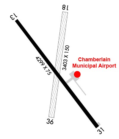
| Facility Name: | CHAMBERLAIN MUNI |
| City Name: | CHAMBERLAIN |
| County: | BRULE |
| State abbrev: | SD |
| State Name: | SOUTH DAKOTA |
| | |
| Ownership: | PUBLICLY OWNED |
| Use: | OPEN TO THE PUBLIC |
| Owner's Name: | CITY OF CHAMBERLAIN |
| Address: | 715 N. MAIN ST. |
| | CHAMBERLAIN, SD 57325 |
| Owner's Phone: | 605-680-9935 |
| | |
| Manager's Name: | DUSTEN HRABE |
| Address: | 101 AIRPORT ROAD |
| | CHAMBERLAIN, SD 57325 |
| Phone: | 605-680-9935 |
| | |
| FAA Region: | GREAT LAKES |
| FAA Field Office: | DMA |
Runway Identifications
Runway Identification: 13/31Length: 4299 ft
Width: 75 ft
Surface: ASPHALT-FAIR CONDITION
Edge lights: Medium IntensityTreatment: NONE
| | Runway: 13 | | Runway: 31 |
| Mag heading: | 136° | Mag heading: | 316° |
| Rwy Slope: | -.42% Down | Rwy Slope: | .42% Up |
| Approach: | | Approach: | |
| Pattern: | Left Traffic | Pattern: | Left Traffic |
| Markings: | NONPRECISION INSTRUMENT | Markings: | NONPRECISION INSTRUMENT |
| Marking Condition: | FAIR | Marking Condition: | FAIR |
| Arresting Dev: | | Arresting Dev: | |
| Lat & Long: | N4346.2 W09919.6 | Lat. & Long.: | N4345.7 W09919.0 |
| Elev: | 1696.3 ft. MSL | Elev: | 1678.1 ft. MSL |
| TCH: | 40 ft. AGL | TCH: | 40 ft. AGL |
| Visual Glide Path: | 3.00 degrees | Visual Glide Path: | 3.00 degrees |
| Displaced Threshold: | No | Displaced Threshold: | No |
| Touchdown Zone: | YES | Touchdown Zone: | YES |
| Touchdown Elev.: | 1696.3 feet | Touchdown Elev.: | 1687.4 feet |
| Visual Glide Slope: | 2-Light PAPI on LEFT side of Runway | Visual Glide Slope: | 2-Light PAPI on LEFT side of Runway |
| RVR Equipment: | | RVR Equipment: | |
| RVV Equipment: | NO | RVV Equipment: | NO |
| Approach Lights: | | Approach Lights: | |
| REIL: | NO | REIL: | NO |
| Centerline Lights: | NO | Centerline Lights: | NO |
| Touchdown lights: | NO | Touchdown lights: | NO |
| Runway Category: | Runway with a Non-precision Approach | Runway Category: | Runway with a Non-precision Approach |
| Declared Distances: | | Declared Distances: | |
| Obstructions: | TREE | Obstructions: | |
| Marked: | NOT Marked/Lighted | Marked: | |
| Clearance slope: | 20:1 | Clearance slope: | 50:1 |
| Obstruction height: | 64 feet AGL | Obstruction height: | |
| Dist. from runway: | 1539 feet | Dist. from runway: | |
| Centerline offset: | 415 left of centerline | Centerline offset: | |
| Comments: | | Comments: | |
Runway Identification: 18/36Length: 3403 ft
Width: 150 ft
Surface: GRASS-GOOD CONDITION
Edge lights: Treatment: NONE
| | Runway: 18 | | Runway: 36 |
| Mag heading: | 182° | Mag heading: | 2° |
| Rwy Slope: | -.47% Down | Rwy Slope: | .47% Up |
| Approach: | | Approach: | |
| Pattern: | Left Traffic | Pattern: | Left Traffic |
| Markings: | | Markings: | |
| Marking Condition: | MKD WITH WHITE/BLACK TIPPED MKR CONES. | Marking Condition: | MKD WITH WHITE/BLACK TIPPED MKR CONES. |
| Arresting Dev: | | Arresting Dev: | |
| Lat & Long: | N4346.3 W09919.2 | Lat. & Long.: | N4345.7 W09919.3 |
| Elev: | 1696.0 ft. MSL | Elev: | 1680.0 ft. MSL |
| TCH: | | TCH: | |
| Visual Glide Path: | | Visual Glide Path: | |
| Displaced Threshold: | No | Displaced Threshold: | No |
| Touchdown Zone: | YES | Touchdown Zone: | YES |
| Touchdown Elev.: | 1696.0 feet | Touchdown Elev.: | 1693.1 feet |
| Visual Glide Slope: | | Visual Glide Slope: | |
| RVR Equipment: | | RVR Equipment: | |
| RVV Equipment: | NO | RVV Equipment: | NO |
| Approach Lights: | | Approach Lights: | |
| REIL: | NO | REIL: | NO |
| Centerline Lights: | NO | Centerline Lights: | NO |
| Touchdown lights: | NO | Touchdown lights: | NO |
| Runway Category: | Runway with a Visual Approach | Runway Category: | Runway with a Visual Approach |
| Declared Distances: | | Declared Distances: | |
| Obstructions: | POLE | Obstructions: | |
| Marked: | NOT Marked/Lighted | Marked: | |
| Clearance slope: | 21:1 | Clearance slope: | 50:1 |
| Obstruction height: | 46 feet AGL | Obstruction height: | |
| Dist. from runway: | 1000 feet | Dist. from runway: | |
| Centerline offset: | | Centerline offset: | |
| Comments: | | Comments: | |