
| ||||||||||||||||||||||||||||||||
| ||||||||||||||||||||||||||||||||
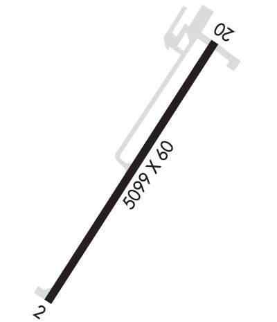
| Rwy | Rwy | |||||||
| 5099x60 | 5099' | 5099x60 | 5099' | |||||
| Runway ID | Single Wheel | Double Wheel | Double Tandem Wheel | Dual Double Wheel |
| 03/21 | 12,000 | N/A | N/A | N/A |
| These numbers are Advisory and are not limits. The Airport Manager should have more accurate Weight Limits | ||||
| FltPlan does not have IFR approach charts available for K9S5. |
 Airport Diagram might not be current. | |
| Facility Name: | THREE FORKS |
| City Name: | THREE FORKS |
| County: | GALLATIN |
| State abbrev: | MT |
| State Name: | MONTANA |
| Ownership: | PUBLICLY OWNED |
| Use: | OPEN TO THE PUBLIC |
| Owner's Name: | GALLATIN COUNTY |
| Address: | 311 WEST MAIN RM 306 |
| BOZEMAN, MT 59715 | |
| Owner's Phone: | 406-582-3000 |
| Manager's Name: | NICK BILTON |
| Address: | P.O. BOX 978 |
| THREE FORKS, MT 59752 | |
| Phone: | 406-570-0803 |
| FAA Region: | NORTHWEST MOUNTAIN |
| FAA Field Office: | HLN |
| Date | Sunrise | Sunset |
|---|---|---|
| 04/16/24 Tuesday | 6:37 | 20:16 |
| 04/17/24 Wednesday | 6:35 | 20:17 |
| 04/18/24 Thursday | 6:33 | 20:18 |
| 04/19/24 Friday | 6:32 | 20:20 |
| 04/20/24 Saturday | 6:30 | 20:21 |
| 04/21/24 Sunday | 6:28 | 20:22 |
| 04/22/24 Monday | 6:27 | 20:23 |
| 04/23/24 Tuesday | 6:25 | 20:25 |
| 04/24/24 Wednesday | 6:23 | 20:26 |
| 04/25/24 Thursday | 6:22 | 20:27 |
| 04/26/24 Friday | 6:20 | 20:29 |
| 04/27/24 Saturday | 6:18 | 20:30 |
| 04/28/24 Sunday | 6:17 | 20:31 |
| 04/29/24 Monday | 6:15 | 20:33 |
| Airport Attendance Schedule | CONTINUOUS |
| Airport Status | OPERATIONAL (This Status can change at any time - please check NOTAMS) |
| Airport Lighting Schedule | ACTVT REILS RWY 03 & 21; PAPI RWY 03 & 21; MIRL RWY 03/21 - CTAF |
| Airport Storage Available | Tie Downs, Hanger |
| Extra Services Available | Crop Dusting, Flight Instruction, Parachute Jumping |
| Wind Indicator | YES - (lighted) |
| Control Tower | NO |
| CTAF Frequency | 122.800 |
| Unicom Frequency | 122.800; AUTOMATED UNICOM. |
| Rotating Beacon Color | WG |
| Segmented Circle | YES |
| Landing Fee | NO |
| Airport Inspected | STATE - performed by STATE AERONAUTICAL PERSONNEL |
| Inspection Date | 06/30/2023 |
| Type of Fuel Available | Grade 100LL; -10FUEL 24 HR CREDIT CARD SVC AVBL. |
| Airframe Repair Service | MAJOR |
| Power Plant Repair Service | MAJOR |
| Latitude | N4552.7 |
| Longitude | W11134.2 (ESTIMATED) |
| Arpt Elevation | 4089ft (SURVEYED) |
| Magnetic Variation | 16E |
| 1 miles SE | of THREE FORKS |
| Traffic Pattern Altitude | |
| Sectional Chart | GREAT FALLS |
| Operations (Reported) | Yearly | Avg. Daily |
|---|---|---|
| General Aviation Transient | 3000 | 8 |
| General Aviation Local | 7000 | 19 |
| Air Taxi | 30 | 0 |
| Commerical | 0 | 0 |
| Commuter | 0 | 0 |
| Military | 1000 | 3 |
| Aircraft based on Field | |
|---|---|
| General Aviation Singles | 26 |
| General Aviation Multi | 1 |
| Jet Aircraft | 0 |
| General Aviation Helicopters | 0 |
| Military Aircraft | 0 |
| Gliders | 0 |
| Ultralights | 2; ULTRALIGHT ACTIVITY ON & INVOF ARPT. |
| FSS on field | NO |
| FSS tie-in | GREAT FALLS |
| FSS Phone | 1-800-WX-BRIEF |
| Who issues Notams | GTF |
| Notam D service at airport | YES |
| ARTCC Name | SALT LAKE CITY |
| Airport Certification | |
| Aircraft Rescue & Firefighting Index | None |
| Airport of Entry | No |
| Custom Landing Rights | No |
| Joint Civil/Military | No |
| Military Landing rights | No |
| NATIONAL PLAN OF INTEGRATED AIRPORT SYSTEMS (NPIAS) |
| GRANT AGREEMENTS UNDER FAAP/ADAP/AIP |
| ASSURANCES PURSUANT TO TITLE VI, CIVIL RIGHTS ACT OF 1964 |
| OCCASIONAL AEROBATIC MANEUVERS INVOF ARPT. |
| UPON DEPARTURE, ALL ACFT MUST REACH 500 FT ALTITUDE PRIOR TO MAKING ANY TURNS. |
| FOR CD CTC BIG SKY APCH AT 208-364-5860/5861, IF UNABLE CTC SALT LAKE ARTCC AT 801-320-2568. |
| Runway: 03 | Runway: 21 | ||
| Mag heading: | 24° | Mag heading: | 204° |
| Rwy Slope: | -.17% Down | Rwy Slope: | .17% Up |
| Approach: | Approach: | ||
| Pattern: | Left Traffic | Pattern: | Left Traffic |
| Markings: | BASIC | Markings: | BASIC |
| Marking Condition: | GOOD | Marking Condition: | GOOD |
| Arresting Dev: | Arresting Dev: | ||
| Lat & Long: | N4552.4 W11134.6 | Lat. & Long.: | N4553.0 W11133.8 |
| Elev: | 4089.2 ft. MSL | Elev: | 4080.7 ft. MSL |
| TCH: | 25 ft. AGL | TCH: | 29 ft. AGL |
| Visual Glide Path: | 3.00 degrees | Visual Glide Path: | 3.25 degrees |
| Displaced Threshold: | No | Displaced Threshold: | No |
| Touchdown Zone: | YES | Touchdown Zone: | YES |
| Touchdown Elev.: | 4089.4 feet | Touchdown Elev.: | 4087.1 feet |
| Visual Glide Slope: | 2-Light PAPI on LEFT side of Runway | Visual Glide Slope: | 2-Light PAPI on LEFT side of Runway |
| RVR Equipment: | RVR Equipment: | ||
| RVV Equipment: | NO | RVV Equipment: | NO |
| Approach Lights: | Approach Lights: | ||
| REIL: | YES | REIL: | YES |
| Centerline Lights: | NO | Centerline Lights: | NO |
| Touchdown lights: | NO | Touchdown lights: | NO |
| Runway Category: | Runway with a Visual Approach | Runway Category: | Runway with a Visual Approach |
| Declared Distances: | Declared Distances: |
