
| ||||||||||||||||||||||||||||||||||||||||||||
| ||||||||||||||||||||||||||||||||||||||||||||
| Rwy | Rwy | |||||||
| 2500x50 | 2500' | 2500x50 | 2500' | |||||
| Runway ID | Single Wheel | Double Wheel | Double Tandem Wheel | Dual Double Wheel |
| 04/22 | N/A | N/A | N/A | N/A |
| These numbers are Advisory and are not limits. The Airport Manager should have more accurate Weight Limits | ||||
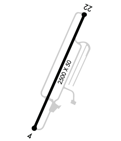 Airport Diagram might not be current. | |
| Facility Name: | SEAMANS FLD |
| City Name: | FACTORYVILLE |
| County: | LACKAWANNA |
| State abbrev: | PA |
| State Name: | PENNSYLVANIA |
| Ownership: | PRIVATELY OWNED |
| Use: | OPEN TO THE PUBLIC |
| Owner's Name: | RMB AVIATION LLC |
| Address: | 65 WINDSOCK LANE |
| FACTORYVILLE, PA 18419 | |
| Owner's Phone: | 570-945-5125 |
| Manager's Name: | JASON CORBY |
| Address: | 65 WINDSOCK LANE |
| FACTORYVILLE, PA 18419 | |
| Phone: | 570-945-5125 |
| FAA Region: | EASTERN |
| FAA Field Office: | HAR |
| Date | Sunrise | Sunset |
|---|---|---|
| 04/18/24 Thursday | 6:17 | 19:48 |
| 04/19/24 Friday | 6:16 | 19:49 |
| 04/20/24 Saturday | 6:14 | 19:50 |
| 04/21/24 Sunday | 6:13 | 19:51 |
| 04/22/24 Monday | 6:11 | 19:52 |
| 04/23/24 Tuesday | 6:10 | 19:53 |
| 04/24/24 Wednesday | 6:08 | 19:54 |
| 04/25/24 Thursday | 6:07 | 19:55 |
| 04/26/24 Friday | 6:06 | 19:56 |
| 04/27/24 Saturday | 6:04 | 19:57 |
| 04/28/24 Sunday | 6:03 | 19:59 |
| 04/29/24 Monday | 6:02 | 20:00 |
| 04/30/24 Tuesday | 6:00 | 20:01 |
| 05/01/24 Wednesday | 5:59 | 20:02 |
| Airport Attendance Schedule | 7 Days A Week 0900-1700; FOR SVC AFT HRS CTC 570-945-5125. |
| Airport Status | OPERATIONAL (This Status can change at any time - please check NOTAMS) |
| Airport Lighting Schedule | SS-SR |
| Airport Storage Available | Tie Downs, Hanger |
| Extra Services Available | NONE |
| Wind Indicator | YES - (lighted) |
| Control Tower | NO |
| CTAF Frequency | 122.700 |
| Unicom Frequency | 122.700 |
| Rotating Beacon Color | WG |
| Segmented Circle | NO |
| Landing Fee | NO |
| Airport Inspected | STATE - performed by STATE AERONAUTICAL PERSONNEL |
| Inspection Date | 11/30/2023 |
| Type of Fuel Available | Grade 100LL |
| Airframe Repair Service | NONE |
| Power Plant Repair Service | NONE |
| Latitude | N4135.4 |
| Longitude | W07545.4 (ESTIMATED) |
| Arpt Elevation | 1209ft (ESTIMATED) |
| Magnetic Variation | 12W |
| 2 miles N | of FACTORYVILLE |
| Traffic Pattern Altitude | |
| Sectional Chart | NEW YORK |
| Operations (Reported) | Yearly | Avg. Daily |
|---|---|---|
| General Aviation Transient | 3500 | 10 |
| General Aviation Local | 10500 | 29 |
| Air Taxi | 101 | 0 |
| Commerical | 0 | 0 |
| Commuter | 0 | 0 |
| Military | 10 | 0 |
| Aircraft based on Field | |
|---|---|
| General Aviation Singles | 35 |
| General Aviation Multi | 0 |
| Jet Aircraft | 0 |
| General Aviation Helicopters | 1 |
| Military Aircraft | 0 |
| Gliders | 0 |
| Ultralights | 1 |
| FSS on field | NO |
| FSS tie-in | WILLIAMSPORT |
| FSS Phone | 1-800-WX-BRIEF |
| Who issues Notams | IPT |
| Notam D service at airport | YES |
| ARTCC Name | NEW YORK |
| Airport Certification | |
| Aircraft Rescue & Firefighting Index | None |
| Airport of Entry | No |
| Custom Landing Rights | No |
| Joint Civil/Military | No |
| Military Landing rights | No |
| THIS AIRPORT HAS BEEN SURVEYED BY THE NATIONAL GEODETIC SURVEY. |
| FOR CD CTC WILKES-BARRE APCH AT 570-655-2084. |
Airport Communications & Frequencies:
| ||||||||||||||
| Runway: 04 | Runway: 22 | ||
| Mag heading: | 36° | Mag heading: | 216° |
| Rwy Slope: | .77% Up | Rwy Slope: | -.77% Down |
| Approach: | Approach: | ||
| Pattern: | Left Traffic | Pattern: | Left Traffic |
| Markings: | NONPRECISION INSTRUMENT | Markings: | BASIC |
| Marking Condition: | GOOD | Marking Condition: | GOOD |
| Arresting Dev: | Arresting Dev: | ||
| Lat & Long: | N4135.1 W07545.5 | Lat. & Long.: | N4135.5 W07545.3 |
| Elev: | 1184.2 ft. MSL | Elev: | 1203.4 ft. MSL |
| TCH: | TCH: | ||
| Visual Glide Path: | Visual Glide Path: | ||
| Displaced Threshold: | No | Displaced Threshold: | No |
| Touchdown Zone: | YES | Touchdown Zone: | YES |
| Touchdown Elev.: | 1209.0 feet | Touchdown Elev.: | 1209.0 feet |
| Visual Glide Slope: | Visual Glide Slope: | ||
| RVR Equipment: | RVR Equipment: | ||
| RVV Equipment: | NO | RVV Equipment: | NO |
| Approach Lights: | Approach Lights: | ||
| REIL: | NO | REIL: | NO |
| Centerline Lights: | NO | Centerline Lights: | NO |
| Touchdown lights: | NO | Touchdown lights: | NO |
| Runway Category: | Runway with a Non-precision Approach | Runway Category: | Runway with a Visual Approach |
| Declared Distances: | Declared Distances: | ||
| Comments: | 13 FT BRUSH 127 FT FM THLD 62 FT RIGHT. | Comments: | 37 FT TREES 87 FT FM THLD 207 FT RIGHT. |
