Click here for more info on on SMS!

K9M8

SHERIDAN MUNI
SHERIDAN
AR
Time Zone: Central
Lat: N 3419.7
Long: W 09221.1
Elev: 236
Var: -00
Longest Runway: 3202
CTAF: 122.8

FBO & Flight Services info for K9M8

FBOs: Update your Fuel Prices

SHERIDAN MUNIPh: 870-941-9595
-
Freq: 122.8
Service
Jet
100LL
SAF
MoGas
Full        Caution: Fuel prices have not been updated in 32 days.
Last Update: 03/17/2024 14:38

Self  5.15    
 Address: 233 AIRPORT RD   SHERIDAN, AR 72150
If you are an FBO, call 1-203-262-1700 to update your info or email: FltPlan.Advertising@garmin.com
Advertise your FBO on FltPlan.com

Runway & Approach Info for K9M8
Rwy
Length
Land Dist**
Approach*
  Rwy
Length
Land Dist**
Approach*
01
3202x75  3202'          
 
  
19
  3202x75  3202'          
 
 * only ILS, LOC, LDA, and SDF approaches to a specific runway are shown
** For any Declared Landing Distance Available, please see A/FD or Approach plates
Runway Weight Capability (lbs.) Help
Runway IDSingle WheelDouble WheelDouble Tandem WheelDual Double Wheel
01/1912,500N/AN/AN/A
These numbers are Advisory and are not limits.   The Airport Manager should have more accurate Weight Limits
Approach Charts
Approaches    
Current Weather/Notams
Customs Information Send updates to Support@FltPlan.com
Customs Not Available
Database effective 04/18/2024
Airport Diagram of K9M8
Airport Diagram might not be current.

Facility Name: SHERIDAN-GRANT COUNTY RGNL
City Name: SHERIDAN
County: GRANT
State abbrev: AR
State Name: ARKANSAS
   
Ownership: PUBLICLY OWNED
Use: OPEN TO THE PUBLIC
Owner's Name: SHERIDAN & GRANT COUNTY
Address: 101 W. CENTER STREET, ROOM 112
 SHERIDAN, AR 72150
Owner's Phone: 870-942-2031
  
Manager's Name: KEVIN RUTHERFORD
Address: 233 AIRPORT ROAD
 SHERIDAN, AR 72150
Phone: 870-941-9595
   
FAA Region: SOUTHWEST
FAA Field Office: AOK


Sunrise / Sunset times for SHERIDAN-GRANT COUNTY RGNL

DateSunriseSunset
04/17/24 Wednesday6:3519:43
04/18/24 Thursday6:3419:44
04/19/24 Friday6:3219:45
04/20/24 Saturday6:3119:46
04/21/24 Sunday6:3019:47
04/22/24 Monday6:2919:47
04/23/24 Tuesday6:2819:48
04/24/24 Wednesday6:2619:49
04/25/24 Thursday6:2519:50
04/26/24 Friday6:2419:50
04/27/24 Saturday6:2319:51
04/28/24 Sunday6:2219:52
04/29/24 Monday6:2119:53
04/30/24 Tuesday6:2019:54

Airport Facilities

Airport Attendance ScheduleUNATTENDED
Airport Status OPERATIONAL (This Status can change at any time - please check NOTAMS)
Airport Lighting ScheduleACTVT PAPI RWYS 01 & 19; MIRL RWY 01/19 - CTAF.
Airport Storage AvailableTie Downs
Extra Services AvailableNONE
Wind IndicatorYES - (lighted)
Control TowerNO
CTAF Frequency122.800
Unicom Frequency122.800
Rotating Beacon ColorWG
Segmented CircleYES
Landing FeeNO

Airport Inspection Data

Airport InspectedSTATE - performed by STATE AERONAUTICAL PERSONNEL
Inspection Date01/02/2024

Airport Services

Type of Fuel AvailableGrade 100LL; -10SELF SERVICE FUEL AVBL 24 HRS WITH CREDIT CARD.
Airframe Repair ServiceNONE
Power Plant Repair ServiceNONE

Geographic Data

LatitudeN3419.7
LongitudeW09221.1 (ESTIMATED)
Arpt Elevation236ft (SURVEYED)
Magnetic Variation00E
3 miles Eof SHERIDAN
Traffic Pattern Altitude
Sectional ChartMEMPHIS

Aircraft Data

Operations (Reported)YearlyAvg. Daily
General Aviation Transient 500014
General Aviation Local 34009
Air Taxi 00
Commerical 00
Commuter 00
Military 2001
Aircraft based on Field
General Aviation Singles 18
General Aviation Multi 1
Jet Aircraft 0
General Aviation Helicopters 0
Military Aircraft 0
Gliders 1
Ultralights 0

FAA Services

FSS on field NO
FSS tie-in JONESBORO
FSS Phone 1-800-WX-BRIEF
Who issues Notams JBR
Notam D service at airport YES
ARTCC Name MEMPHIS

Federal Status

Airport Certification
Aircraft Rescue & Firefighting IndexNone
Airport of EntryNo
Custom Landing RightsNo
Joint Civil/MilitaryNo
Military Landing rightsNo

Federal Agreements

NATIONAL PLAN OF INTEGRATED AIRPORT SYSTEMS (NPIAS)

Remarks

FOR CD CTC LITTLE ROCK APCH 501-379-2908 OR LITTLE ROCK ATCT 501-379-2911.
Airport Communications & Frequencies:
CTAF Frequency:
122.800
Unicom Frequency:
122.800
Remarks
  • APCH/DEP SVC PRVDD BY LITTLE ROCK APCH (LIT) ON 135.4/353.6.
  • LITTLE ROCK Primary Approach Frequencies:  
    135.4
    353.6
    LITTLE ROCK Primary Departure Frequencies:  
    135.4
    353.6
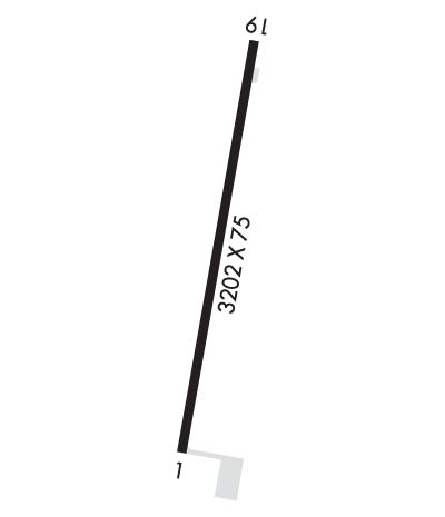
    Runway Identifications
    Runway Identification: 01/19
    Length: 3202 ft
    Width: 75 ft
    Surface: ASPHALT-FAIR CONDITION
    Edge lights: Medium Intensity

    Treatment: NONE

     Runway: 01   Runway: 19
    Mag heading: 12°Mag heading: 192°
    Rwy Slope: .23% UpRwy Slope: -.23% Down
    Approach: Approach:
    Pattern: Left TrafficPattern: Left Traffic
    Markings: NONPRECISION INSTRUMENTMarkings: NONPRECISION INSTRUMENT
    Marking Condition: FAIRMarking Condition: FAIR
    Arresting Dev: Arresting Dev:
    Lat & Long: N3419.4  W09221.1Lat. & Long.: N3419.9  W09221.0
    Elev: 228.5 ft. MSLElev: 236.0 ft. MSL
    TCH: 38 ft. AGLTCH: 43 ft. AGL
    Visual Glide Path: 3.75 degreesVisual Glide Path: 3.25 degrees
    Displaced Threshold: NoDisplaced Threshold: No
    Touchdown Zone: YESTouchdown Zone: YES
    Touchdown Elev.: 235.4 feetTouchdown Elev.: 236.0 feet
    Visual Glide Slope: 2-Light PAPI on LEFT side of Runway; RWY 01 PAPI UNUSBL BYD 6 DEG LEFT OF CNTRLN.Visual Glide Slope: 2-Light PAPI on LEFT side of Runway
    RVR Equipment: RVR Equipment:
    RVV Equipment: NORVV Equipment: NO
    Approach Lights: Approach Lights:
    REIL: NOREIL: NO
    Centerline Lights: NOCenterline Lights: NO
    Touchdown lights: NOTouchdown lights: NO
    Runway Category: Runway with a Non-precision ApproachRunway Category: Runway with a Non-precision Approach
    Declared Distances: Declared Distances:
    Obstructions: TREESObstructions: TREES
    Marked: NOT Marked/LightedMarked: NOT Marked/Lighted
    Clearance slope: 21:1Clearance slope: 38:1
    Obstruction height: 60 feet AGLObstruction height: 30 feet AGL
    Dist. from runway: 1500 feetDist. from runway: 1350 feet
    Centerline offset: Centerline offset:
    Comments: Comments:
    C:/P: