| ||||||||||||||||||||||||||||||||
| ||||||||||||||||||||||||||||||||
| Rwy | Rwy | |||||||
| 2235x100 | 2235' | 2235x100 | 2235' | |||||
| Runway ID | Single Wheel | Double Wheel | Double Tandem Wheel | Dual Double Wheel |
| 09/27 | N/A | N/A | N/A | N/A |
| These numbers are Advisory and are not limits. The Airport Manager should have more accurate Weight Limits | ||||
| FltPlan does not have IFR approach charts available for K9I0. |
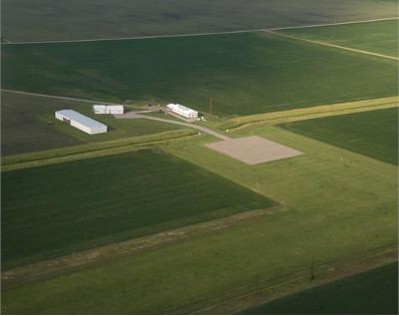
| Facility Name: | HAVANA RGNL |
| City Name: | HAVANA |
| County: | MASON |
| State abbrev: | IL |
| State Name: | ILLINOIS |
| Ownership: | PUBLICLY OWNED |
| Use: | OPEN TO THE PUBLIC |
| Owner's Name: | HAVANA REGIONAL PORT DISTRICT |
| Address: | 17787 SHERWOOD FOREST RD |
| HAVANA, IL 62644 | |
| Owner's Phone: | (217) 725-0628 |
| Manager's Name: | BOB MARTIN |
| Address: | 18206 QUIVER BEACH RD; EMAIL ADDRESS: FLYBYEWIRE@GMAIL.COM (ALL LOWER CASE) |
| HAVANA, IL 62644-6895 | |
| Phone: | 309-543-9006 |
| FAA Region: | GREAT LAKES |
| FAA Field Office: | CHI |
| Date | Sunrise | Sunset |
|---|---|---|
| 04/25/24 Thursday | 6:07 | 19:50 |
| 04/26/24 Friday | 6:05 | 19:51 |
| 04/27/24 Saturday | 6:04 | 19:52 |
| 04/28/24 Sunday | 6:03 | 19:53 |
| 04/29/24 Monday | 6:01 | 19:54 |
| 04/30/24 Tuesday | 6:00 | 19:55 |
| 05/01/24 Wednesday | 5:59 | 19:56 |
| 05/02/24 Thursday | 5:57 | 19:57 |
| 05/03/24 Friday | 5:56 | 19:58 |
| 05/04/24 Saturday | 5:55 | 19:59 |
| 05/05/24 Sunday | 5:54 | 20:00 |
| 05/06/24 Monday | 5:53 | 20:01 |
| 05/07/24 Tuesday | 5:52 | 20:02 |
| 05/08/24 Wednesday | 5:51 | 20:03 |
| Airport Attendance Schedule | IRREGULAR |
| Airport Status | OPERATIONAL (This Status can change at any time - please check NOTAMS) |
| Airport Lighting Schedule | |
| Airport Storage Available | Tie Downs |
| Extra Services Available | Flight Instruction, Annual Surveying |
| Wind Indicator | YES - (lighted) |
| Control Tower | NO |
| CTAF Frequency | 122.900 |
| Unicom Frequency | |
| Rotating Beacon Color | WG |
| Segmented Circle | NO |
| Landing Fee | NO |
| Airport Inspected | STATE - performed by STATE AERONAUTICAL PERSONNEL |
| Inspection Date | 06/01/2023 |
| Type of Fuel Available | Grade 100LL; -10SELF SVC FUEL AVBL 24 HRS. |
| Airframe Repair Service | NONE |
| Power Plant Repair Service | NONE |
| Latitude | N4013.4 |
| Longitude | W09001.4 (ESTIMATED) |
| Arpt Elevation | 488ft (SURVEYED) |
| Magnetic Variation | 01E |
| 5 miles SE | of HAVANA |
| Traffic Pattern Altitude | |
| Sectional Chart | CHICAGO |
| Operations (Reported) | Yearly | Avg. Daily |
|---|---|---|
| General Aviation Transient | 400 | 1 |
| General Aviation Local | 1000 | 3 |
| Air Taxi | 0 | 0 |
| Commerical | 0 | 0 |
| Commuter | 0 | 0 |
| Military | 0 | 0 |
| Aircraft based on Field | |
|---|---|
| General Aviation Singles | 13 |
| General Aviation Multi | 0 |
| Jet Aircraft | 0 |
| General Aviation Helicopters | 0 |
| Military Aircraft | 0 |
| Gliders | 0 |
| Ultralights | 0 |
| FSS on field | NO |
| FSS tie-in | KANKAKEE |
| FSS Phone | 1-800-WX-BRIEF |
| Who issues Notams | IKK |
| Notam D service at airport | YES |
| ARTCC Name | CHICAGO |
| Airport Certification | |
| Aircraft Rescue & Firefighting Index | None |
| Airport of Entry | No |
| Custom Landing Rights | No |
| Joint Civil/Military | No |
| Military Landing rights | No |
| NATIONAL PLAN OF INTEGRATED AIRPORT SYSTEMS (NPIAS) |
| SURPLUS PROPERTY AGREEMENT UNDER PUBLIC LAW 289 |
| ASSURANCES PURSUANT TO TITLE VI, CIVIL RIGHTS ACT OF 1964 |
| FOR CD CTC ST LOUIS APCH 314-890-1017. |
| Runway: 09 | Runway: 27 | ||
| Mag heading: | N/A | Mag heading: | N/A |
| Rwy Slope: | .12% Up | Rwy Slope: | -.12% Down |
| Approach: | Approach: | ||
| Pattern: | Left Traffic | Pattern: | Left Traffic |
| Markings: | Markings: | ||
| Marking Condition: | Marking Condition: | ||
| Arresting Dev: | Arresting Dev: | ||
| Lat & Long: | N4013.4 W09001.6 | Lat. & Long.: | N4013.4 W09001.1 |
| Elev: | 485.5 ft. MSL | Elev: | 488.2 ft. MSL |
| TCH: | TCH: | ||
| Visual Glide Path: | Visual Glide Path: | ||
| Displaced Threshold: | No | Displaced Threshold: | No |
| Touchdown Zone: | YES | Touchdown Zone: | YES |
| Touchdown Elev.: | 488.2 feet | Touchdown Elev.: | 488.2 feet |
| Visual Glide Slope: | Visual Glide Slope: | ||
| RVR Equipment: | RVR Equipment: | ||
| RVV Equipment: | NO | RVV Equipment: | NO |
| Approach Lights: | Approach Lights: | ||
| REIL: | NO | REIL: | NO |
| Centerline Lights: | NO | Centerline Lights: | NO |
| Touchdown lights: | NO | Touchdown lights: | NO |
| Runway Category: | Runway with a Visual Approach | Runway Category: | Runway with a Visual Approach |
| Declared Distances: | Declared Distances: |