Current Weather/Notams (Metars, TAFs, Notams, NWS Forecast, PIREPS, and nearby weather)
Customs Information Send updates to Support@FltPlan.com
Customs Not Available
Database effective 05/16/2024
Airport Diagram might not be current.
|
| Facility Name: | EBENSBURG |
| City Name: | EBENSBURG |
| County: | CAMBRIA |
| State abbrev: | PA |
| State Name: | PENNSYLVANIA |
| | |
| Ownership: | PUBLICLY OWNED |
| Use: | OPEN TO THE PUBLIC |
| Owner's Name: | BOROUGH OF EBENSBURG |
| Address: | 300 W HIGH ST |
| | EBENSBURG, PA 15931 |
| Owner's Phone: | (814) 472-0843 |
| | |
| Manager's Name: | JOHN GLASS |
| Address: | 3920 ADMIRAL PEARY HIGHWAY |
| | EBENSBURG, PA 15931 |
| Phone: | (814) 934-5717 |
| | |
| FAA Region: | EASTERN |
| FAA Field Office: | HAR |
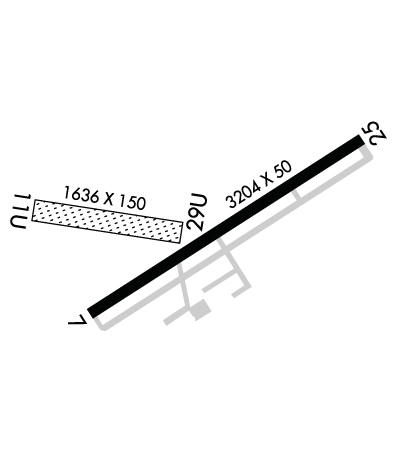
Runway Identifications
Runway Identification: 07/25Length: 3204 ft
Width: 50 ft
Surface: ASPHALT-GOOD CONDITION
Edge lights: Medium IntensityTreatment: NONE
| | Runway: 07 | | Runway: 25 |
| Mag heading: | 66° | Mag heading: | 246° |
| Rwy Slope: | .56% Up | Rwy Slope: | -.56% Down |
| Approach: | | Approach: | |
| Pattern: | Left Traffic | Pattern: | Left Traffic |
| Markings: | NONSTANDARD | Markings: | NONSTANDARD |
| Marking Condition: | GOOD; BSC RWY MARKINGS | Marking Condition: | GOOD; BSC RWY MARKINGS |
| Arresting Dev: | | Arresting Dev: | |
| Lat & Long: | N4027.5 W07846.7 | Lat. & Long.: | N4027.8 W07846.1 |
| Elev: | 2080.0 ft. MSL | Elev: | 2098.0 ft. MSL |
| TCH: | | TCH: | |
| Visual Glide Path: | | Visual Glide Path: | |
| Displaced Threshold: | No | Displaced Threshold: | No |
| Touchdown Zone: | YES | Touchdown Zone: | YES |
| Touchdown Elev.: | 2088.0 feet | Touchdown Elev.: | 2098.0 feet |
| Visual Glide Slope: | | Visual Glide Slope: | |
| RVR Equipment: | | RVR Equipment: | |
| RVV Equipment: | NO | RVV Equipment: | NO |
| Approach Lights: | | Approach Lights: | |
| REIL: | NO | REIL: | NO |
| Centerline Lights: | NO | Centerline Lights: | NO |
| Touchdown lights: | NO | Touchdown lights: | NO |
| Runway Category: | Runway with a Non-precision Approach | Runway Category: | Runway with a Non-precision Approach |
| Declared Distances: | | Declared Distances: | |
| Obstructions: | TREES | Obstructions: | ROAD |
| Marked: | NOT Marked/Lighted | Marked: | NOT Marked/Lighted |
| Clearance slope: | 7:1 | Clearance slope: | 14:1 |
| Obstruction height: | 59 feet AGL | Obstruction height: | 26 feet AGL |
| Dist. from runway: | 643 feet | Dist. from runway: | 585 feet |
| Centerline offset: | 281 right of centerline | Centerline offset: | |
| Comments: | | Comments: | |
Runway Identification: 11U/29ULength: 1636 ft
Width: 150 ft
Surface: GRASS NATURAL SOIL-FAIR CONDITION
Edge lights: Treatment: NONE
| | Runway: 11U | | Runway: 29U |
| Mag heading: | 107° | Mag heading: | 287° |
| Rwy Slope: | 1.89% Up | Rwy Slope: | -1.89% Down |
| Approach: | | Approach: | |
| Pattern: | Left Traffic | Pattern: | Left Traffic |
| Markings: | | Markings: | |
| Marking Condition: | RWY 11U/29U RWY BOUNDARY MKD WITH YELLOW CONES. | Marking Condition: | |
| Arresting Dev: | | Arresting Dev: | |
| Lat & Long: | N4027.7 W07846.9 | Lat. & Long.: | N4027.7 W07846.5 |
| Elev: | 2063.0 ft. MSL | Elev: | 2094.0 ft. MSL |
| TCH: | | TCH: | |
| Visual Glide Path: | | Visual Glide Path: | |
| Displaced Threshold: | No | Displaced Threshold: | No |
| Touchdown Zone: | YES | Touchdown Zone: | YES |
| Touchdown Elev.: | 2094.0 feet | Touchdown Elev.: | 2094.0 feet |
| Visual Glide Slope: | | Visual Glide Slope: | |
| RVR Equipment: | | RVR Equipment: | |
| RVV Equipment: | NO | RVV Equipment: | NO |
| Approach Lights: | | Approach Lights: | |
| REIL: | NO | REIL: | NO |
| Centerline Lights: | NO | Centerline Lights: | NO |
| Touchdown lights: | NO | Touchdown lights: | NO |
| Runway Category: | Runway with a Visual Approach | Runway Category: | Runway with a Visual Approach |
| Declared Distances: | | Declared Distances: | |
| Obstructions: | TREE | Obstructions: | TREE |
| Marked: | NOT Marked/Lighted | Marked: | NOT Marked/Lighted |
| Clearance slope: | 11:1 | Clearance slope: | 13:1 |
| Obstruction height: | 8 feet AGL | Obstruction height: | 50 feet AGL |
| Dist. from runway: | 82 feet | Dist. from runway: | 674 feet |
| Centerline offset: | 17 left of centerline | Centerline offset: | 28 feet left of centerline |
| Comments: | | Comments: | |

