Click here for more info on on SMS!

K9G6

PINE HILL
ALBION
NY
Time Zone: Eastern
Lat: N 4310.4
Long: W 07816.5
Elev: 669
Var: +11
Longest Runway: 2659
CTAF: 123.0

FBO & Flight Services info for K9G6

FBOs: Update your Fuel Prices

AIRPORT UNATTDPh: 716-589-7758
-
Freq: 123.0
Service
Jet
100LL
SAF
MoGas
Fuel Avail: NO FUEL AVAILABLE
Full        Last Update: 04/19/2024 00:01:46

Self        
If you are an FBO, call 1-203-262-1700 to update your info or email: FltPlan.Advertising@garmin.com
Advertise your FBO on FltPlan.com

Runway & Approach Info for K9G6
Rwy
Length
Land Dist**
Approach*
  Rwy
Length
Land Dist**
Approach*
10
2659x36  2659'          
 
  
28
  2659x36  2409'          
 
 * only ILS, LOC, LDA, and SDF approaches to a specific runway are shown
** For any Declared Landing Distance Available, please see A/FD or Approach plates
Runway Weight Capability (lbs.) Help
Runway IDSingle WheelDouble WheelDouble Tandem WheelDual Double Wheel
10/2812,000N/AN/AN/A
These numbers are Advisory and are not limits.   The Airport Manager should have more accurate Weight Limits
Approach Charts
Approaches    
Current Weather/Notams
Customs Information Send updates to Support@FltPlan.com
Customs Not Available
Database effective 04/18/2024
Airport Diagram of K9G6
Airport Diagram might not be current.

Facility Name: PINE HILL
City Name: ALBION
County: ORLEANS
State abbrev: NY
State Name: NEW YORK
   
Ownership: PRIVATELY OWNED
Use: OPEN TO THE PUBLIC
Owner's Name: HAINES FAMILY FARM, LLC
Address: 4906 PINE HILL ROAD
 ALBION, NY 14411-9760
Owner's Phone: 716-597-7393
  
Manager's Name: TIMOTHY ALLEN
Address: 4906 PINE HILL ROAD
 ALBION, NY 14411
Phone: 716-597-7393
   
FAA Region: EASTERN
FAA Field Office: NYC


Sunrise / Sunset times for PINE HILL

DateSunriseSunset
04/18/24 Thursday6:2520:00
04/19/24 Friday6:2320:01
04/20/24 Saturday6:2220:03
04/21/24 Sunday6:2020:04
04/22/24 Monday6:1920:05
04/23/24 Tuesday6:1720:06
04/24/24 Wednesday6:1620:07
04/25/24 Thursday6:1420:08
04/26/24 Friday6:1320:10
04/27/24 Saturday6:1120:11
04/28/24 Sunday6:1020:12
04/29/24 Monday6:0820:13
04/30/24 Tuesday6:0720:14
05/01/24 Wednesday6:0620:15

Airport Facilities

Airport Attendance ScheduleUNATTENDED
Airport Status OPERATIONAL (This Status can change at any time - please check NOTAMS)
Airport Lighting Schedule
Airport Storage AvailableTie Downs
Extra Services AvailableParachute Jumping
Wind IndicatorYES - (unlit)
Control TowerNO
CTAF Frequency123.000
Unicom Frequency123.000
Rotating Beacon Color
Segmented CircleNO
Landing FeeNO

Airport Inspection Data

Airport InspectedSTATE - performed by PRIVATE CONTRACT PERSONNEL
Inspection Date07/14/2023

Airport Services

Type of Fuel AvailableNone
Airframe Repair ServiceNone
Power Plant Repair ServiceNone

Geographic Data

LatitudeN4310.4
LongitudeW07816.5 (ESTIMATED)
Arpt Elevation669ft (SURVEYED)
Magnetic Variation11W
5 miles SWof ALBION
Traffic Pattern Altitude1500
Sectional ChartDETROIT

Aircraft Data

Operations (Reported)YearlyAvg. Daily
General Aviation Transient 400011
General Aviation Local 700019
Air Taxi 00
Commerical 00
Commuter 00
Military 5001
Aircraft based on Field
General Aviation Singles 10
General Aviation Multi 0
Jet Aircraft 0
General Aviation Helicopters 0
Military Aircraft 0
Gliders 0
Ultralights 1

FAA Services

FSS on field NO
FSS tie-in BUFFALO
FSS Phone 1-800-WX-BRIEF
Who issues Notams BUF
Notam D service at airport YES
ARTCC Name CLEVELAND

Federal Status

Airport Certification
Aircraft Rescue & Firefighting IndexNone
Airport of EntryNo
Custom Landing RightsNo
Joint Civil/MilitaryNo
Military Landing rightsNo

Remarks

THIS AIRPORT HAS BEEN SURVEYED BY THE NATIONAL GEODETIC SURVEY.
245 FT TWR 1500 FT SSE APCH END RY 28.
FOR CD CTC CLEVELAND ARTCC AT 440-774-0490.
Airport Communications & Frequencies:
CTAF Frequency:
123.000
Unicom Frequency:
123.000
BUFFALO Primary Approach Frequencies:  
126.15
263.125
BUFFALO Primary Departure Frequencies:  
126.15
263.125
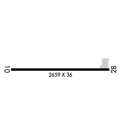
Runway Identifications
Runway Identification: 10/28
Length: 2659 ft
Width: 36 ft
Surface: ASPHALT-FAIR CONDITION
Edge lights:

Treatment: NONE

 Runway: 10   Runway: 28
Mag heading: 102°Mag heading: 282°
Rwy Slope: .60% UpRwy Slope: -.60% Down
Approach: Approach:
Pattern: Left TrafficPattern: Left Traffic
Markings: NONEMarkings: NONE
Marking Condition: Marking Condition:
Arresting Dev: Arresting Dev:
Lat & Long: N4310.4  W07816.8Lat. & Long.: N4310.4  W07816.2
Elev: 653.0 ft. MSLElev: 669.0 ft. MSL
TCH: TCH:
Visual Glide Path: Visual Glide Path:
Displaced Threshold: NoDisplaced Threshold: 250 feet
Touchdown Zone: YESTouchdown Zone: YES
Touchdown Elev.: 669.0 feetTouchdown Elev.: 669.0 feet
Visual Glide Slope: Visual Glide Slope:
RVR Equipment: RVR Equipment:
RVV Equipment: NORVV Equipment: NO
Approach Lights: Approach Lights:
REIL: NOREIL: NO
Centerline Lights: NOCenterline Lights: NO
Touchdown lights: NOTouchdown lights: NO
Runway Category: Runway with a Visual ApproachRunway Category: Runway with a Visual Approach
Declared Distances: Declared Distances:
Obstructions: TREEObstructions: ROAD
Marked: NOT Marked/LightedMarked: NOT Marked/Lighted
Clearance slope: 11:1Clearance slope: APCH SLOPE 13:1 AT DTHR; OVR 38 FT TREE, 510 FT DSTC, 70 FT LEFT.
Obstruction height: 76 feet AGLObstruction height: 16 feet AGL
Dist. from runway: 1067 feetDist. from runway: 210 feet
Centerline offset: 180 right of centerlineCenterline offset:
Comments: Comments: 8 FT SIGN; 185 FT DSTC, 64 FT RIGHT.
C:/P: