Current Weather/Notams (Metars, TAFs, Notams, NWS Forecast, PIREPS, and nearby weather)
Customs Information Send updates to Support@FltPlan.com
Customs Not Available
Database effective 05/16/2024
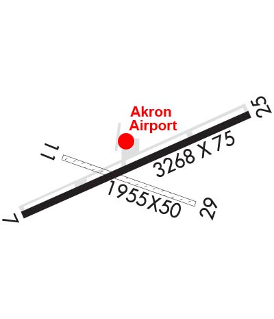
Airport Diagram might not be current. Facility Name: AKRON/JESSON FLD City Name: AKRON County: ERIE State abbrev: NY State Name: NEW YORK Ownership: PRIVATELY OWNED Use: OPEN TO THE PUBLIC Owner's Name: CHRISTIAN AIRMEN INC. Address: PO BOX 126 AKRON, NY 14001 Owner's Phone: 716-542-4607 Manager's Name: ALLISON FREY Address: BOX 126, JOHN ST. AKRON, NY 14001 Phone: 716-542-4607 FAA Region: EASTERN FAA Field Office: NYC
Runway Identifications Help
Runway Identification: 07/25 Length: 3268 ftWidth: 75 ftSurface: ASPHALT-FAIR CONDITIONEdge lights: Medium Intensity Treatment: NONE Runway: 07 Runway: 25 Mag heading: 71° Mag heading: 251° Rwy Slope: .30% Up Rwy Slope: -.30% Down Approach: Approach: Pattern: Left Traffic Pattern: Left Traffic Markings: NONPRECISION INSTRUMENT Markings: NONPRECISION INSTRUMENT Marking Condition: FAIR Marking Condition: FAIR Arresting Dev: Arresting Dev: Lat & Long: N4301.1 W07829.3 Lat. & Long.: N4301.4 W07828.6 Elev: 829.8 ft. MSL Elev: 839.7 ft. MSL TCH: 54 ft. AGL TCH: 55 ft. AGL Visual Glide Path: 4.00 degrees Visual Glide Path: 4.00 degrees Displaced Threshold: No Displaced Threshold: No Touchdown Zone: YES Touchdown Zone: YES Touchdown Elev.: 839.0 feet Touchdown Elev.: 839.7 feet Visual Glide Slope: 2-Light PAPI on LEFT side of Runway; UNUSBL BYD 7 DEGS RIGHT OF CNTRLN. Visual Glide Slope: 2-Light PAPI on LEFT side of Runway RVR Equipment: RVR Equipment: RVV Equipment: NO RVV Equipment: NO Approach Lights: Approach Lights: REIL: NO REIL: YES Centerline Lights: NO Centerline Lights: NO Touchdown lights: NO Touchdown lights: NO Runway Category: Runway with a Non-precision Approach Runway Category: Runway with a Non-precision Approach Declared Distances: Declared Distances: Obstructions: TREES Obstructions: TREES Marked: NOT Marked/Lighted Marked: NOT Marked/Lighted Clearance slope: Clearance slope: 1:1 Obstruction height: 36 feet AGL Obstruction height: 26 feet AGL Dist. from runway: 214 feet Dist. from runway: 240 feet Centerline offset: 214 right of centerline Centerline offset: 240 feet right of centerline Comments: +8 FT FENCE AT 195 FT OUT, 165 FT RT. Comments: +8 FT FENCE 198 FT OUT AND 213 FT LEFT.
Runway Identification: 11/29 Length: 1955 ftWidth: 50 ftSurface: GRASS-GOOD CONDITIONEdge lights: Treatment: NONE Runway: 11 Runway: 29 Mag heading: 120° Mag heading: 300° Approach: Approach: Pattern: Left Traffic Pattern: Left Traffic Markings: Markings: Marking Condition: Marking Condition: Arresting Dev: Arresting Dev: Lat & Long: Lat. & Long.: Elev: N/A Elev: N/A TCH: TCH: Visual Glide Path: Visual Glide Path: Displaced Threshold: No Displaced Threshold: No Touchdown Zone: NO Touchdown Zone: NO Touchdown Elev.: Touchdown Elev.: Visual Glide Slope: Visual Glide Slope: RVR Equipment: RVR Equipment: RVV Equipment: NO RVV Equipment: NO Approach Lights: Approach Lights: REIL: NO REIL: NO Centerline Lights: NO Centerline Lights: NO Touchdown lights: NO Touchdown lights: NO Runway Category: Runway with a Visual Approach Runway Category: Runway with a Visual Approach Declared Distances: Declared Distances: Obstructions: TREES Obstructions: TREES Marked: NOT Marked/Lighted Marked: NOT Marked/Lighted Clearance slope: Clearance slope: Obstruction height: 25 feet AGL Obstruction height: 50 feet AGL Dist. from runway: 0 feet Dist. from runway: 0 feet Centerline offset: Centerline offset: 30 feet right of centerline Comments: Comments: