Current Weather/Notams (Metars, TAFs, Notams, NWS Forecast, PIREPS, and nearby weather)
Customs Information Send updates to Support@FltPlan.com
Customs Not Available
Database effective 05/16/2024
Airport Diagram might not be current.
|
| Facility Name: | HASTINGS |
| City Name: | HASTINGS |
| County: | BARRY |
| State abbrev: | MI |
| State Name: | MICHIGAN |
| | |
| Ownership: | PUBLICLY OWNED |
| Use: | OPEN TO THE PUBLIC |
| Owner's Name: | HASTINGS CITY-BARRY CO ARPT COMM |
| Address: | 2505 MURPHY DR. |
| | HASTINGS, MI 49058 |
| Owner's Phone: | 269-945-6306 |
| | |
| Manager's Name: | MARK NOTEBOOM; ASST MGR MARK ANDERSON 269-804-9588 |
| Address: | 2505 MURPHY DR. |
| | HASTINGS, MI 49058 |
| Phone: | 269-945-6306; AMGR CELL 269-838-5874 |
| | |
| FAA Region: | GREAT LAKES |
| FAA Field Office: | DET |
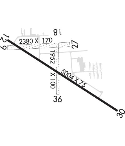
Runway Identifications
Runway Identification: 09/27Length: 2380 ft
Width: 170 ft
Surface: GRASS-FAIR CONDITION
Edge lights: Treatment: NONE
| | Runway: 09 | | Runway: 27 |
| Mag heading: | 93° | Mag heading: | 273° |
| Rwy Slope: | .15% Up | Rwy Slope: | -.15% Down |
| Approach: | | Approach: | |
| Pattern: | Left Traffic | Pattern: | Left Traffic |
| Markings: | | Markings: | |
| Marking Condition: | RWY 09/27 & RWY 18/36 MKD WITH 3 FT YELLOW CONES. | Marking Condition: | |
| Arresting Dev: | | Arresting Dev: | |
| Lat & Long: | N4239.9 W08521.2 | Lat. & Long.: | N4239.9 W08520.6 |
| Elev: | 794.7 ft. MSL | Elev: | 798.2 ft. MSL |
| TCH: | | TCH: | |
| Visual Glide Path: | | Visual Glide Path: | |
| Displaced Threshold: | 191 feet | Displaced Threshold: | 374 feet |
| Touchdown Zone: | YES | Touchdown Zone: | YES |
| Touchdown Elev.: | 798.9 feet | Touchdown Elev.: | 798.1 feet |
| Visual Glide Slope: | | Visual Glide Slope: | |
| RVR Equipment: | | RVR Equipment: | |
| RVV Equipment: | NO | RVV Equipment: | NO |
| Approach Lights: | | Approach Lights: | |
| REIL: | NO | REIL: | NO |
| Centerline Lights: | NO | Centerline Lights: | NO |
| Touchdown lights: | NO | Touchdown lights: | NO |
| Runway Category: | Runway with a Visual Approach | Runway Category: | Runway with a Visual Approach |
| Declared Distances: | | Declared Distances: | |
| Obstructions: | TREE | Obstructions: | TREE |
| Marked: | NOT Marked/Lighted | Marked: | NOT Marked/Lighted |
| Clearance slope: | 9:1; APCH RATIO 15:1 AT DSPLCD THR. +40 FT TREE, 630 FT DIST, 75 FT L. | Clearance slope: | 13:1; APCH RATIO 19:1 AT DSPLCD THR. +91 FT TREE, 1785 DIST, 0 FT BASE LEG. |
| Obstruction height: | 10 feet AGL | Obstruction height: | 77 feet AGL |
| Dist. from runway: | 96 feet | Dist. from runway: | 1001 feet |
| Centerline offset: | 11 right of centerline | Centerline offset: | 248 feet right of centerline |
| Comments: | | Comments: | |
Runway Identification: 12/30Length: 5003 ft
Width: 75 ft
Surface: ASPHALT-GOOD CONDITION
Edge lights: Medium IntensityTreatment: NONE
| | Runway: 12 | | Runway: 30 |
| Mag heading: | 128° | Mag heading: | 308° |
| Rwy Slope: | -.01% Down | Rwy Slope: | .01% Up |
| Approach: | | Approach: | |
| Pattern: | Left Traffic | Pattern: | Left Traffic |
| Markings: | NONPRECISION INSTRUMENT | Markings: | NONPRECISION INSTRUMENT |
| Marking Condition: | FAIR | Marking Condition: | FAIR |
| Arresting Dev: | | Arresting Dev: | |
| Lat & Long: | N4240.0 W08521.2 | Lat. & Long.: | N4239.5 W08520.2 |
| Elev: | 797.1 ft. MSL | Elev: | 796.7 ft. MSL |
| TCH: | 34 ft. AGL | TCH: | 43 ft. AGL |
| Visual Glide Path: | 4.00 degrees | Visual Glide Path: | 3.00 degrees |
| Displaced Threshold: | 241 feet | Displaced Threshold: | 251 feet |
| Touchdown Zone: | YES | Touchdown Zone: | YES |
| Touchdown Elev.: | 799.5 feet | Touchdown Elev.: | 799.5 feet |
| Visual Glide Slope: | 4-Light PAPI on RIGHT side of Runway | Visual Glide Slope: | 4-Light PAPI on LEFT side of Runway; PAPI UNUSBL BYD 5 DEGS LEFT OF CNTRLN. |
| RVR Equipment: | | RVR Equipment: | |
| RVV Equipment: | NO | RVV Equipment: | NO |
| Approach Lights: | | Approach Lights: | |
| REIL: | YES | REIL: | YES |
| Centerline Lights: | NO | Centerline Lights: | NO |
| Touchdown lights: | NO | Touchdown lights: | NO |
| Runway Category: | Runway with a Non-precision Approach | Runway Category: | Runway with a Non-precision Approach |
| Declared Distances: | | Declared Distances: | |
| Obstructions: | TREE | Obstructions: | TREE |
| Marked: | NOT Marked/Lighted | Marked: | NOT Marked/Lighted |
| Clearance slope: | 10:1; APCH RATIO 20:1 AT DSPLCD THR. | Clearance slope: | 1:1 |
| Obstruction height: | 39 feet AGL | Obstruction height: | 34 feet AGL |
| Dist. from runway: | 592 feet | Dist. from runway: | 200 feet |
| Centerline offset: | 275 right of centerline | Centerline offset: | 250 feet left of centerline |
| Comments: | | Comments: | |
Runway Identification: 18/36Length: 1952 ft
Width: 200 ft
Surface: GRASS-FAIR CONDITION
Edge lights: Treatment: NONE
| | Runway: 18 | | Runway: 36 |
| Mag heading: | 185° | Mag heading: | 5° |
| Rwy Slope: | .06% Up | Rwy Slope: | -.06% Down |
| Approach: | | Approach: | |
| Pattern: | Left Traffic | Pattern: | Left Traffic |
| Markings: | | Markings: | |
| Marking Condition: | | Marking Condition: | |
| Arresting Dev: | | Arresting Dev: | |
| Lat & Long: | N4239.9 W08520.7 | Lat. & Long.: | N4239.6 W08520.7 |
| Elev: | 797.0 ft. MSL | Elev: | 798.1 ft. MSL |
| TCH: | | TCH: | |
| Visual Glide Path: | | Visual Glide Path: | |
| Displaced Threshold: | No | Displaced Threshold: | No |
| Touchdown Zone: | YES | Touchdown Zone: | YES |
| Touchdown Elev.: | 800.4 feet | Touchdown Elev.: | 800.4 feet |
| Visual Glide Slope: | | Visual Glide Slope: | |
| RVR Equipment: | | RVR Equipment: | |
| RVV Equipment: | NO | RVV Equipment: | NO |
| Approach Lights: | | Approach Lights: | |
| REIL: | NO | REIL: | NO |
| Centerline Lights: | NO | Centerline Lights: | NO |
| Touchdown lights: | NO | Touchdown lights: | NO |
| Runway Category: | Runway with a Visual Approach | Runway Category: | Runway with a Visual Approach |
| Declared Distances: | | Declared Distances: | |
| Obstructions: | TREE | Obstructions: | TREE |
| Marked: | NOT Marked/Lighted | Marked: | NOT Marked/Lighted |
| Clearance slope: | 11:1 | Clearance slope: | 6:1 |
| Obstruction height: | 64 feet AGL | Obstruction height: | 38 feet AGL |
| Dist. from runway: | 732 feet | Dist. from runway: | 233 feet |
| Centerline offset: | 171 right of centerline | Centerline offset: | 161 feet right of centerline |
| Comments: | | Comments: | |

