Current Weather/Notams (Metars, TAFs, Notams, NWS Forecast, PIREPS, and nearby weather)
Customs Information Send updates to Support@FltPlan.com
Customs Not Available
Database effective 05/16/2024
Airport Diagram might not be current.
|
| Facility Name: | COURTLAND |
| City Name: | COURTLAND |
| County: | LAWRENCE |
| State abbrev: | AL |
| State Name: | ALABAMA |
| | |
| Ownership: | PUBLICLY OWNED |
| Use: | OPEN TO THE PUBLIC |
| Owner's Name: | LAWRENCE COUNTY COMMISSION |
| Address: | P. O. BOX 307 |
| | MOULTON, AL 35650 |
| Owner's Phone: | 256-974-0663 |
| | |
| Manager's Name: | GLENN REIST |
| Address: | 52 AIR FORCE STREET |
| | COURTLAND, AL 35618 |
| Phone: | 256-318-4536 |
| | |
| FAA Region: | SOUTHERN |
| FAA Field Office: | JAN |
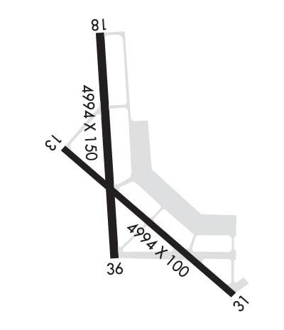
Runway Identifications
Runway Identification: 13/31Length: 4994 ft
Width: 100 ft
Surface: CONCRETE-POOR CONDITION
Edge lights: High IntensityTreatment: NONE
| | Runway: 13 | | Runway: 31 |
| Mag heading: | 133° | Mag heading: | 313° |
| Rwy Slope: | -.20% Down | Rwy Slope: | .20% Up |
| Approach: | | Approach: | |
| Pattern: | Left Traffic | Pattern: | Left Traffic |
| Markings: | NONPRECISION INSTRUMENT | Markings: | NONPRECISION INSTRUMENT |
| Marking Condition: | FAIR | Marking Condition: | FAIR |
| Arresting Dev: | | Arresting Dev: | |
| Lat & Long: | N3439.7 W08721.2 | Lat. & Long.: | N3439.2 W08720.5 |
| Elev: | 581.5 ft. MSL | Elev: | 571.7 ft. MSL |
| TCH: | | TCH: | |
| Visual Glide Path: | | Visual Glide Path: | |
| Displaced Threshold: | No | Displaced Threshold: | No |
| Touchdown Zone: | YES | Touchdown Zone: | YES |
| Touchdown Elev.: | 582.4 feet | Touchdown Elev.: | 578.7 feet |
| Visual Glide Slope: | | Visual Glide Slope: | |
| RVR Equipment: | | RVR Equipment: | |
| RVV Equipment: | NO | RVV Equipment: | NO |
| Approach Lights: | | Approach Lights: | |
| REIL: | NO | REIL: | NO |
| Centerline Lights: | NO | Centerline Lights: | NO |
| Touchdown lights: | NO | Touchdown lights: | NO |
| Runway Category: | Runway with a Non-precision Approach having visibility minimums greater than 3/4 mile | Runway Category: | Runway with a Non-precision Approach having visibility minimums greater than 3/4 mile |
| Declared Distances: | | Declared Distances: | |
Runway Identification: 18/36Length: 3484 ft
Width: 150 ft
Surface: CONCRETE-POOR CONDITION
Edge lights: Treatment: NONE
| | Runway: 18 | | Runway: 36 |
| Mag heading: | 178° | Mag heading: | 358° |
| Rwy Slope: | -.22% Down | Rwy Slope: | .22% Up |
| Approach: | | Approach: | |
| Pattern: | Left Traffic | Pattern: | Left Traffic |
| Markings: | BASIC | Markings: | BASIC |
| Marking Condition: | FAIR | Marking Condition: | POOR; RWY 36 MARKINGS FADED. |
| Arresting Dev: | | Arresting Dev: | |
| Lat & Long: | N3439.9 W08721.0 | Lat. & Long.: | N3439.3 W08721.0 |
| Elev: | 588.0 ft. MSL | Elev: | 580.2 ft. MSL |
| TCH: | | TCH: | |
| Visual Glide Path: | | Visual Glide Path: | |
| Displaced Threshold: | No | Displaced Threshold: | No |
| Touchdown Zone: | YES | Touchdown Zone: | YES |
| Touchdown Elev.: | 588.0 feet | Touchdown Elev.: | 586.8 feet |
| Visual Glide Slope: | | Visual Glide Slope: | |
| RVR Equipment: | | RVR Equipment: | |
| RVV Equipment: | NO | RVV Equipment: | NO |
| Approach Lights: | | Approach Lights: | |
| REIL: | NO | REIL: | NO |
| Centerline Lights: | NO | Centerline Lights: | NO |
| Touchdown lights: | NO | Touchdown lights: | NO |
| Runway Category: | Runway with a Visual Approach | Runway Category: | Runway with a Visual Approach |
| Declared Distances: | | Declared Distances: | |

