Approach Charts
| FltPlan does not have IFR approach charts available for K95F. |
Current Weather/Notams (Metars, TAFs, Notams, NWS Forecast, PIREPS, and nearby weather)
Customs Information Send updates to Support@FltPlan.com
Customs Not Available
Database effective 05/16/2024
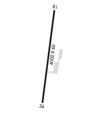
Airport Diagram might not be current.
|
| Facility Name: | CLEVELAND MUNI |
| City Name: | CLEVELAND |
| County: | PAWNEE |
| State abbrev: | OK |
| State Name: | OKLAHOMA |
| | |
| Ownership: | PUBLICLY OWNED |
| Use: | OPEN TO THE PUBLIC |
| Owner's Name: | CITY OF CLEVELAND |
| Address: | 201 N. BROADWAY, P.O. DRAWER 190 |
| | CLEVELAND, OK 74020 |
| Owner's Phone: | 918-358-3506 |
| | |
| Manager's Name: | MIKE VAUGHAN; CITY MANAGER. |
| Address: | 105 W CADDO ST |
| | CLEVELAND, OK 74020 |
| Phone: | 918-358-3506 |
| | |
| FAA Region: | SOUTHWEST |
| FAA Field Office: | AOK |
Runway Identifications
Runway Identification: 18/36Length: 4000 ft
Width: 60 ft
Surface: ASPHALT-GOOD CONDITION
Edge lights: Medium IntensityTreatment: NONE
| | Runway: 18 | | Runway: 36 |
| Mag heading: | 181° | Mag heading: | 1° |
| Rwy Slope: | .13% Up | Rwy Slope: | -.13% Down |
| Approach: | | Approach: | |
| Pattern: | Left Traffic | Pattern: | Left Traffic |
| Markings: | BASIC | Markings: | BASIC |
| Marking Condition: | GOOD | Marking Condition: | GOOD |
| Arresting Dev: | | Arresting Dev: | |
| Lat & Long: | N3617.4 W09627.7 | Lat. & Long.: | N3616.7 W09627.9 |
| Elev: | 971.0 ft. MSL | Elev: | 976.0 ft. MSL |
| TCH: | | TCH: | |
| Visual Glide Path: | 2.75 degrees | Visual Glide Path: | 2.75 degrees |
| Displaced Threshold: | No | Displaced Threshold: | No |
| Touchdown Zone: | NO | Touchdown Zone: | NO |
| Touchdown Elev.: | | Touchdown Elev.: | |
| Visual Glide Slope: | 2-Light PAPI on LEFT side of Runway | Visual Glide Slope: | 2-Light PAPI on LEFT side of Runway |
| RVR Equipment: | | RVR Equipment: | |
| RVV Equipment: | NO | RVV Equipment: | NO |
| Approach Lights: | | Approach Lights: | |
| REIL: | NO | REIL: | NO |
| Centerline Lights: | NO | Centerline Lights: | NO |
| Touchdown lights: | NO | Touchdown lights: | NO |
| Runway Category: | Runway with a Visual Approach | Runway Category: | Runway with a Visual Approach |
| Declared Distances: | | Declared Distances: | |
| Obstructions: | PLINE | Obstructions: | TREE |
| Marked: | NOT Marked/Lighted | Marked: | NOT Marked/Lighted |
| Clearance slope: | 17:1 | Clearance slope: | 20:1 |
| Obstruction height: | 68 feet AGL | Obstruction height: | 40 feet AGL |
| Dist. from runway: | 1408 feet | Dist. from runway: | 1000 feet |
| Centerline offset: | 245 left of centerline | Centerline offset: | 50 feet right of centerline |
| Comments: | | Comments: | |

