Approach Charts
| FltPlan does not have IFR approach charts available for K90F. |
Current Weather/Notams (Metars, TAFs, Notams, NWS Forecast, PIREPS, and nearby weather)
Customs Information Send updates to Support@FltPlan.com
Customs Not Available
Database effective 04/18/2024
Airport Diagram might not be current.
|
| Facility Name: | BROKEN BOW |
| City Name: | BROKEN BOW |
| County: | MC CURTAIN |
| State abbrev: | OK |
| State Name: | OKLAHOMA |
| | |
| Ownership: | PUBLICLY OWNED |
| Use: | OPEN TO THE PUBLIC |
| Owner's Name: | CITY OF BROKEN BOW |
| Address: | CITY HALL, 210 N. BROADWAY |
| | BROKEN BOW, OK 74728 |
| Owner's Phone: | 580-584-2282 |
| | |
| Manager's Name: | VICKIE PATTERSON; CITY MANAGER. |
| Address: | CITY HALL, 210 N. BROADWAY |
| | BROKEN BOW, OK 74728 |
| Phone: | 580-584-2885 |
| | |
| FAA Region: | SOUTHWEST |
| FAA Field Office: | AOK |
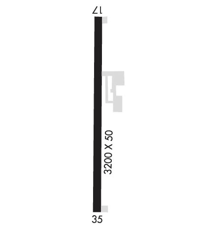
Runway Identifications
Runway Identification: 17/35Length: 3200 ft
Width: 50 ft
Surface: ASPHALT-GOOD CONDITION
Edge lights: Medium IntensityTreatment: NONE
| | Runway: 17 | | Runway: 35 |
| Mag heading: | 175° | Mag heading: | 355° |
| Rwy Slope: | .03% Up | Rwy Slope: | -.03% Down |
| Approach: | | Approach: | |
| Pattern: | Left Traffic | Pattern: | Left Traffic |
| Markings: | BASIC | Markings: | BASIC |
| Marking Condition: | GOOD | Marking Condition: | GOOD |
| Arresting Dev: | | Arresting Dev: | |
| Lat & Long: | N3401.1 W09445.5 | Lat. & Long.: | N3400.5 W09445.5 |
| Elev: | 403.0 ft. MSL | Elev: | 404.0 ft. MSL |
| TCH: | 26 ft. AGL | TCH: | 26 ft. AGL |
| Visual Glide Path: | 2.00 degrees | Visual Glide Path: | 2.00 degrees |
| Displaced Threshold: | No | Displaced Threshold: | No |
| Touchdown Zone: | NO | Touchdown Zone: | NO |
| Touchdown Elev.: | | Touchdown Elev.: | |
| Visual Glide Slope: | 2-Light PAPI on LEFT side of Runway | Visual Glide Slope: | 2-Light PAPI on LEFT side of Runway |
| RVR Equipment: | | RVR Equipment: | |
| RVV Equipment: | NO | RVV Equipment: | NO |
| Approach Lights: | | Approach Lights: | |
| REIL: | NO | REIL: | NO |
| Centerline Lights: | NO | Centerline Lights: | NO |
| Touchdown lights: | NO | Touchdown lights: | NO |
| Runway Category: | Runway with a Visual Approach | Runway Category: | Runway with a Visual Approach |
| Declared Distances: | | Declared Distances: | |
| Obstructions: | TREES | Obstructions: | TREES |
| Marked: | NOT Marked/Lighted | Marked: | NOT Marked/Lighted |
| Clearance slope: | 7:1 | Clearance slope: | 10:1 |
| Obstruction height: | 75 feet AGL | Obstruction height: | 83 feet AGL |
| Dist. from runway: | 770 feet | Dist. from runway: | 1051 feet |
| Centerline offset: | 250 right of centerline | Centerline offset: | 111 feet left of centerline |
| Comments: | | Comments: | |

