Current Weather/Notams (Metars, TAFs, Notams, NWS Forecast, PIREPS, and nearby weather)
Customs Information Send updates to Support@FltPlan.com
Customs Not Available
Database effective 04/18/2024
Airport Diagram might not be current.
|
| Facility Name: | DANVILLE |
| City Name: | DANVILLE |
| County: | NORTHUMBERLAND |
| State abbrev: | PA |
| State Name: | PENNSYLVANIA |
| | |
| Ownership: | PUBLICLY OWNED |
| Use: | OPEN TO THE PUBLIC |
| Owner's Name: | NORTHUMBERLAND & MONTOUR JOINT COMM |
| Address: | 1413 SUNBURY ROAD, ST |
| | DANVILLE, PA 17821 |
| Owner's Phone: | 570-274-6190 |
| | |
| Manager's Name: | CRAIG LAWLER |
| Address: | 1413 SUNBURY ROAD |
| | DANVILLE, PA 17824 |
| Phone: | 570-274-6190 |
| | |
| FAA Region: | EASTERN |
| FAA Field Office: | HAR |
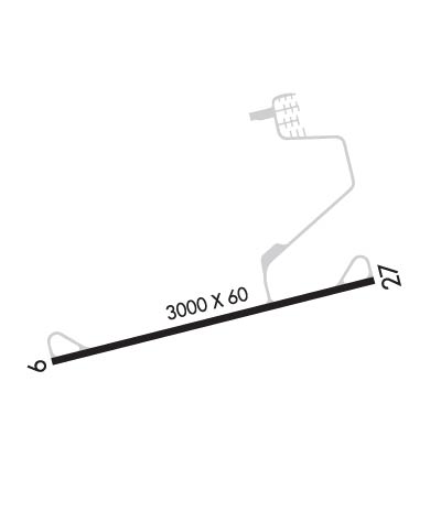
Runway Identifications
Runway Identification: 09/27Length: 3000 ft
Width: 60 ft
Surface: ASPHALT-GOOD CONDITION
Edge lights: Medium IntensityTreatment: NONE
| | Runway: 09 | | Runway: 27 |
| Mag heading: | N/A | Mag heading: | N/A |
| Rwy Slope: | .45% Up | Rwy Slope: | -.45% Down |
| Approach: | | Approach: | |
| Pattern: | Left Traffic | Pattern: | Left Traffic |
| Markings: | NONPRECISION INSTRUMENT | Markings: | NONPRECISION INSTRUMENT |
| Marking Condition: | FAIR | Marking Condition: | FAIR; THR LGTS DSPLCD 365 FT FM RWY END FOR NGT DISPLACEMENT. RWY END LGTD WITH TWO RED LGTS ON LEFT SIDE (NON STD). |
| Arresting Dev: | | Arresting Dev: | |
| Lat & Long: | N4056.8 W07639.0 | Lat. & Long.: | N4057.0 W07638.3 |
| Elev: | 540.7 ft. MSL | Elev: | 554.1 ft. MSL |
| TCH: | | TCH: | |
| Visual Glide Path: | | Visual Glide Path: | |
| Displaced Threshold: | No | Displaced Threshold: | No |
| Touchdown Zone: | YES | Touchdown Zone: | YES |
| Touchdown Elev.: | 559.0 feet | Touchdown Elev.: | 559.0 feet |
| Visual Glide Slope: | | Visual Glide Slope: | |
| RVR Equipment: | | RVR Equipment: | |
| RVV Equipment: | NO | RVV Equipment: | NO |
| Approach Lights: | | Approach Lights: | |
| REIL: | NO | REIL: | NO |
| Centerline Lights: | NO | Centerline Lights: | NO |
| Touchdown lights: | NO | Touchdown lights: | NO |
| Runway Category: | Runway with a Non-precision Approach | Runway Category: | Runway with a Non-precision Approach |
| Declared Distances: | | Declared Distances: | |
| Obstructions: | TREES | Obstructions: | TREES |
| Marked: | NOT Marked/Lighted | Marked: | NOT Marked/Lighted |
| Clearance slope: | 2:1 | Clearance slope: | 8:1 |
| Obstruction height: | 49 feet AGL | Obstruction height: | 85 feet AGL |
| Dist. from runway: | 314 feet | Dist. from runway: | 904 feet |
| Centerline offset: | 246 right of centerline | Centerline offset: | 296 feet left of centerline |
| Comments: | | Comments: | |

