Current Weather/Notams (Metars, TAFs, Notams, NWS Forecast, PIREPS, and nearby weather)
Customs Information Send updates to Support@FltPlan.com
Customs Not Available
Database effective 05/16/2024
Airport Diagram might not be current.
|
| Facility Name: | HARPER MUNI |
| City Name: | HARPER |
| County: | HARPER |
| State abbrev: | KS |
| State Name: | KANSAS |
| | |
| Ownership: | PUBLICLY OWNED |
| Use: | OPEN TO THE PUBLIC |
| Owner's Name: | CITY OF HARPER |
| Address: | 201 W. MAIN |
| | HARPER, KS 67058 |
| Owner's Phone: | 620-896-2511 |
| | |
| Manager's Name: | KAREN BEFORT |
| Address: | 201 WEST MAIN |
| | HARPER, KS 67058 |
| Phone: | 620-896-2511 |
| | |
| FAA Region: | CENTRAL |
| FAA Field Office: | NONE |
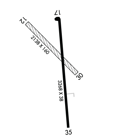
Runway Identifications
Runway Identification: 12/30Length: 2138 ft
Width: 160 ft
Surface: GRASS-GOOD CONDITION
Edge lights: Treatment: NONE
| | Runway: 12 | | Runway: 30 |
| Mag heading: | 127° | Mag heading: | 307° |
| Rwy Slope: | .00% | Rwy Slope: | .00% |
| Approach: | | Approach: | |
| Pattern: | Left Traffic | Pattern: | Left Traffic |
| Markings: | | Markings: | |
| Marking Condition: | GOOD; MARKED WITH ORANGE CONES | Marking Condition: | |
| Arresting Dev: | | Arresting Dev: | |
| Lat & Long: | N3716.9 W09802.8 | Lat. & Long.: | N3716.6 W09802.5 |
| Elev: | 1426.0 ft. MSL | Elev: | 1426.0 ft. MSL |
| TCH: | | TCH: | |
| Visual Glide Path: | | Visual Glide Path: | |
| Displaced Threshold: | No | Displaced Threshold: | No |
| Touchdown Zone: | NO | Touchdown Zone: | NO |
| Touchdown Elev.: | | Touchdown Elev.: | |
| Visual Glide Slope: | | Visual Glide Slope: | |
| RVR Equipment: | | RVR Equipment: | |
| RVV Equipment: | NO | RVV Equipment: | NO |
| Approach Lights: | | Approach Lights: | |
| REIL: | NO | REIL: | NO |
| Centerline Lights: | NO | Centerline Lights: | NO |
| Touchdown lights: | NO | Touchdown lights: | NO |
| Runway Category: | Runway with a Visual Approach | Runway Category: | Runway with a Visual Approach |
| Declared Distances: | | Declared Distances: | |
| Obstructions: | PLINE | Obstructions: | PLINE |
| Marked: | NOT Marked/Lighted | Marked: | NOT Marked/Lighted |
| Clearance slope: | 20:1 | Clearance slope: | 20:1 |
| Obstruction height: | 45 feet AGL | Obstruction height: | 40 feet AGL |
| Dist. from runway: | 900 feet | Dist. from runway: | 800 feet |
| Centerline offset: | | Centerline offset: | |
| Comments: | | Comments: | |
Runway Identification: 17/35Length: 3268 ft
Width: 38 ft
Surface: ASPHALT-GOOD CONDITION
Edge lights: High IntensityTreatment: NONE
| | Runway: 17 | | Runway: 35 |
| Mag heading: | 168° | Mag heading: | 348° |
| Rwy Slope: | -.09% Down | Rwy Slope: | .09% Up |
| Approach: | | Approach: | |
| Pattern: | Left Traffic | Pattern: | Left Traffic |
| Markings: | BASIC | Markings: | BASIC |
| Marking Condition: | GOOD | Marking Condition: | GOOD |
| Arresting Dev: | | Arresting Dev: | |
| Lat & Long: | N3716.9 W09802.6 | Lat. & Long.: | N3716.4 W09802.6 |
| Elev: | 1427.0 ft. MSL | Elev: | 1424.0 ft. MSL |
| TCH: | 57 ft. AGL | TCH: | 58 ft. AGL |
| Visual Glide Path: | 3.25 degrees | Visual Glide Path: | 3.25 degrees |
| Displaced Threshold: | No | Displaced Threshold: | No |
| Touchdown Zone: | YES | Touchdown Zone: | YES |
| Touchdown Elev.: | 1427.0 feet | Touchdown Elev.: | 1427.0 feet |
| Visual Glide Slope: | 2-Light PAPI on LEFT side of Runway; RWY 17 PAPI UNUSBL BYD 3 DEGS L OF CNTRLN. | Visual Glide Slope: | 2-Light PAPI on LEFT side of Runway |
| RVR Equipment: | | RVR Equipment: | |
| RVV Equipment: | NO | RVV Equipment: | NO |
| Approach Lights: | | Approach Lights: | |
| REIL: | NO | REIL: | NO |
| Centerline Lights: | NO | Centerline Lights: | NO |
| Touchdown lights: | NO | Touchdown lights: | NO |
| Runway Category: | Runway with a Visual Approach | Runway Category: | Runway with a Visual Approach |
| Declared Distances: | | Declared Distances: | |
| Obstructions: | TREE | Obstructions: | PLINE |
| Marked: | NOT Marked/Lighted | Marked: | NOT Marked/Lighted |
| Clearance slope: | 5:1 | Clearance slope: | 35:1 |
| Obstruction height: | 42 feet AGL | Obstruction height: | 40 feet AGL |
| Dist. from runway: | 412 feet | Dist. from runway: | 1600 feet |
| Centerline offset: | 88 left of centerline | Centerline offset: | |
| Comments: | | Comments: | |

