Click here for more info on on SMS!

K8G1

WILLARD
WILLARD
OH
Time Zone: Eastern
Lat: N 4102.3
Long: W 08243.5
Elev: 967
Var: +06
Longest Runway: 4028
CTAF: 122.9

FBO & Flight Services info for K8G1

FBOs: Update your Fuel Prices

WILLARD AVIATIONPh: 419-933-7531
-
Freq: 122.9
Service
Jet
100LL
SAF
MoGas
Full  5.49    Last Update: 04/15/2024 12:05

Self        
 Address: 631 MYRTLE AVENUE   WILLARD, OH 44890
If you are an FBO, call 1-203-262-1700 to update your info or email: FltPlan.Advertising@garmin.com
Advertise your FBO on FltPlan.com

Runway & Approach Info for K8G1
Rwy
Length
Land Dist**
Approach*
  Rwy
Length
Land Dist**
Approach*
10
4028x65  3728'          
 
  
28
  4028x65  3418'          
 
 * only ILS, LOC, LDA, and SDF approaches to a specific runway are shown
** For any Declared Landing Distance Available, please see A/FD or Approach plates
Runway Weight Capability (lbs.) Help
Runway IDSingle WheelDouble WheelDouble Tandem WheelDual Double Wheel
10/28N/AN/AN/AN/A
These numbers are Advisory and are not limits.   The Airport Manager should have more accurate Weight Limits
Approach Charts
Approaches    
Current Weather/Notams
Customs Information Send updates to Support@FltPlan.com
Customs Not Available
Database effective 05/16/2024
Airport Diagram of K8G1
Airport Diagram might not be current.

Facility Name: WILLARD
City Name: WILLARD
County: HURON
State abbrev: OH
State Name: OHIO
   
Ownership: PUBLICLY OWNED
Use: OPEN TO THE PUBLIC
Owner's Name: CITY OF WILLARD
Address: 631 S MYRTLE AVE
 WILLARD, OH 44890-1549
Owner's Phone: 419-933-2591
  
Manager's Name: ROB CAVELLO; AIRPORT@WILLARDOHIO.GOV.
Address: 631 S MYRTLE AVE; ARPT PHYS ADS: 3744 STATE ROUTE 103 S, WILLARD, OH 44890.
 WILLARD, OH 44890-1549
Phone: 419-933-7531
   
FAA Region: GREAT LAKES
FAA Field Office: DET


Sunrise / Sunset times for WILLARD

DateSunriseSunset
04/25/24 Thursday6:3620:22
04/26/24 Friday6:3520:23
04/27/24 Saturday6:3320:24
04/28/24 Sunday6:3220:25
04/29/24 Monday6:3020:26
04/30/24 Tuesday6:2920:27
05/01/24 Wednesday6:2820:29
05/02/24 Thursday6:2720:30
05/03/24 Friday6:2520:31
05/04/24 Saturday6:2420:32
05/05/24 Sunday6:2320:33
05/06/24 Monday6:2220:34
05/07/24 Tuesday6:2120:35
05/08/24 Wednesday6:1920:36

Airport Facilities

Airport Attendance ScheduleUNATTENDED
Airport Status OPERATIONAL (This Status can change at any time - please check NOTAMS)
Airport Lighting ScheduleACTVT MIRL RWY 10/28 - CTAF.
Airport Storage AvailableTie Downs
Extra Services AvailableNONE
Wind IndicatorYES - (unlit)
Control TowerNO
CTAF Frequency122.900
Unicom Frequency
Rotating Beacon Color
Segmented CircleNO
Landing FeeNO

Airport Inspection Data

Airport InspectedSTATE - performed by PRIVATE CONTRACT PERSONNEL
Inspection Date07/28/2021

Airport Services

Type of Fuel AvailableGrade 100LL; -10FOR FUEL WKDAYS 0700-1500 CALL AMGR; AFT HRS CALL 419-933-2561.
Airframe Repair ServiceNone
Power Plant Repair ServiceNone

Geographic Data

LatitudeN4102.3
LongitudeW08243.5 (ESTIMATED)
Arpt Elevation966ft (SURVEYED)
Magnetic Variation06W
1 miles Sof WILLARD
Traffic Pattern Altitude
Sectional ChartDETROIT

Aircraft Data

Operations (Reported)YearlyAvg. Daily
General Aviation Transient 5001
General Aviation Local 00
Air Taxi 00
Commerical 00
Commuter 00
Military 150
Aircraft based on Field
General Aviation Singles 0
General Aviation Multi 0
Jet Aircraft 0
General Aviation Helicopters 0
Military Aircraft 0
Gliders 0
Ultralights 0

FAA Services

FSS on field NO
FSS tie-in CLEVELAND
FSS Phone 1-800-WX-BRIEF
Who issues Notams CLE
Notam D service at airport YES
ARTCC Name CLEVELAND

Federal Status

Airport Certification
Aircraft Rescue & Firefighting IndexNone
Airport of EntryNo
Custom Landing RightsNo
Joint Civil/MilitaryNo
Military Landing rightsNo

Remarks

THIS AIRPORT HAS BEEN SURVEYED BY THE NATIONAL GEODETIC SURVEY.
FOR CD CTC CLEVELAND APCH AT 216-352-2323, WHEN APCH CLSD CTC CLEVELAND ARTCC AT 440-774-0222/0490.
RWY 28: AUTO DEALER PRKG LOT LGTS SHINE IN RWY APCH.
DEER, BIRDS, & OTR WILDLIFE ON & INVOF ARPT.
HOSPITAL HELI 0.4 NM EAST OF RWY END 28.
Airport Communications & Frequencies:
CTAF Frequency:
122.900
Remarks
  • APCH/DEP SVC PRVDD BY CLEVELAND APCH (CLE) 0600-0100. APCH/DEP SVC PRVDD BY CLEVELAND ARTCC (ZOB) ON FREQS 135.1/291.725 (FINDLAY RCAG) 0100-0600.
  • COMMUNICATIONS PRVDD BY CLEVELAND RADIO ON FREQ 122.6 (MANSFIELD RCO).
  • CLEVELAND Primary Approach Frequencies:  
    124.2
    360.65
    CLEVELAND Primary Departure Frequencies:  
    124.2
    360.65
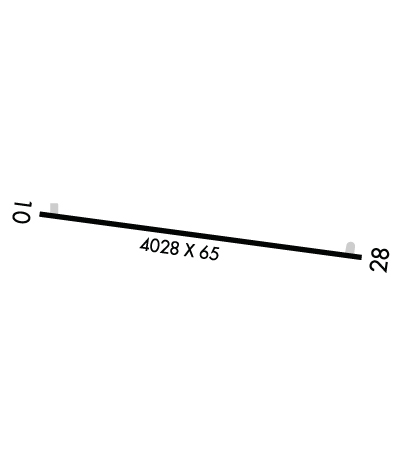
    Runway Identifications
    Runway Identification: 10/28
    Length: 4028 ft
    Width: 65 ft
    Surface: ASPHALT-FAIR CONDITION
    Edge lights: Medium Intensity

    Treatment: NONE

     Runway: 10   Runway: 28
    Mag heading: 103°Mag heading: 283°
    Rwy Slope: -.76% DownRwy Slope: .76% Up
    Approach: Approach:
    Pattern: Left TrafficPattern: Left Traffic
    Markings: BASICMarkings: BASIC
    Marking Condition: GOODMarking Condition: GOOD
    Arresting Dev: Arresting Dev:
    Lat & Long: N4102.4  W08243.9Lat. & Long.: N4102.3  W08243.0
    Elev: 966.6 ft. MSLElev: 936.0 ft. MSL
    TCH: TCH:
    Visual Glide Path: Visual Glide Path:
    Displaced Threshold: 300 feetDisplaced Threshold: 610 feet
    Touchdown Zone: YESTouchdown Zone: YES
    Touchdown Elev.: 965.4 feetTouchdown Elev.: 962.9 feet
    Visual Glide Slope: Visual Glide Slope:
    RVR Equipment: RVR Equipment:
    RVV Equipment: NORVV Equipment: NO
    Approach Lights: Approach Lights:
    REIL: NOREIL: NO
    Centerline Lights: NOCenterline Lights: NO
    Touchdown lights: NOTouchdown lights: NO
    Runway Category: Runway with a Visual ApproachRunway Category: Runway with a Visual Approach
    Declared Distances: Declared Distances:
    Obstructions: BLDG; ALSO 90 FT TREES, 1230 FT DSTC.Obstructions: TREES
    Marked: NOT Marked/LightedMarked: NOT Marked/Lighted
    Clearance slope: APCH RATIO 11:1 TO DTHR OVR 22 FT BLDG, 260 FT DIST, 170 FT R.Clearance slope: 10:1; APCH RATIO 18:1 TO DTHR.
    Obstruction height: 14 feet AGLObstruction height: 100 feet AGL
    Dist. from runway: 201 feetDist. from runway: 1245 feet
    Centerline offset: 95 left of centerlineCenterline offset: 124 feet left of centerline
    Comments: 15 FT ROAD, 75 FT DIST, 125 FT L/R; 15 FT PRKG LOT, 0-90 FT DIST, 50 FT L; 14 FT BLDG, 180 FT DIST, 100 FT L.Comments: 10 FT PRKG LOT, 135-200 FT DIST, 99-105 FT R.
    C:/P: