Click here for more info on on SMS!

K8F6

MURDO MUNI
MURDO
SD
Time Zone: Central
Lat: N 4351.1
Long: W 10042.8
Elev: 2270
Var: -09
Longest Runway: 4000
CTAF: 122.8

FBO & Flight Services info for K8F6

FBOs: Update your Fuel Prices

AIRPORTPh: 605-669-2272
-
Freq: 122.98
Service
Jet
100LL
SAF
MoGas
Fuel Avail: NO FUEL AVAILABLE
Full        Last Update: 04/19/2024 00:01:46

Self        
If you are an FBO, call 1-203-262-1700 to update your info or email: FltPlan.Advertising@garmin.com
Advertise your FBO on FltPlan.com

Runway & Approach Info for K8F6
Rwy
Length
Land Dist**
Approach*
  Rwy
Length
Land Dist**
Approach*
14
4000x60  4000'          
 
  
32
  4000x60  4000'          
 
 * only ILS, LOC, LDA, and SDF approaches to a specific runway are shown
** For any Declared Landing Distance Available, please see A/FD or Approach plates
Runway Weight Capability (lbs.) Help
Runway IDSingle WheelDouble WheelDouble Tandem WheelDual Double Wheel
14/3212,500N/AN/AN/A
These numbers are Advisory and are not limits.   The Airport Manager should have more accurate Weight Limits
Approach Charts
FltPlan does not have IFR approach charts available for K8F6.
Current Weather/Notams
Customs Information Send updates to Support@FltPlan.com
Customs Not Available
Database effective 04/18/2024
Airport Diagram of K8F6
Airport Diagram might not be current.

Facility Name: MURDO MUNI
City Name: MURDO
County: JONES
State abbrev: SD
State Name: SOUTH DAKOTA
   
Ownership: PUBLICLY OWNED
Use: OPEN TO THE PUBLIC
Owner's Name: CITY OF MURDO
Address: PO BOX 432
 MURDO, SD 57559
Owner's Phone: 605-669-2272
  
Manager's Name: JEFF SONDER
Address: PO BOX 432
 MURDO, SD 57559
Phone: 605-669-2272
   
FAA Region: GREAT LAKES
FAA Field Office: DMA


Sunrise / Sunset times for MURDO MUNI

DateSunriseSunset
04/18/24 Thursday6:5420:31
04/19/24 Friday6:5220:32
04/20/24 Saturday6:5020:34
04/21/24 Sunday6:4920:35
04/22/24 Monday6:4720:36
04/23/24 Tuesday6:4620:37
04/24/24 Wednesday6:4420:38
04/25/24 Thursday6:4220:40
04/26/24 Friday6:4120:41
04/27/24 Saturday6:3920:42
04/28/24 Sunday6:3820:43
04/29/24 Monday6:3620:44
04/30/24 Tuesday6:3520:46
05/01/24 Wednesday6:3420:47

Airport Facilities

Airport Attendance ScheduleUNATTENDED
Airport Status OPERATIONAL (This Status can change at any time - please check NOTAMS)
Airport Lighting ScheduleACTVT LIRL RWY 14 & 32 KEY CTAF 5 TIMES.
Airport Storage AvailableTie Downs
Extra Services AvailableCrop Dusting
Wind IndicatorYES - (lighted)
Control TowerNO
CTAF Frequency122.800
Unicom Frequency122.800
Rotating Beacon ColorWG
Segmented CircleYES
Landing FeeNO

Airport Inspection Data

Airport InspectedSTATE - performed by STATE AERONAUTICAL PERSONNEL
Inspection Date09/14/2022

Airport Services

Type of Fuel AvailableNone
Airframe Repair ServiceNone
Power Plant Repair ServiceNONE

Geographic Data

LatitudeN4351.1
LongitudeW10042.8 (ESTIMATED)
Arpt Elevation2270ft (SURVEYED)
Magnetic Variation09E
3 miles Sof MURDO
Traffic Pattern Altitude
Sectional ChartOMAHA

Aircraft Data

Operations (Reported)YearlyAvg. Daily
General Aviation Transient 3001
General Aviation Local 1000
Air Taxi 00
Commerical 00
Commuter 00
Military 00
Aircraft based on Field
General Aviation Singles 3
General Aviation Multi 0
Jet Aircraft 0
General Aviation Helicopters 0
Military Aircraft 0
Gliders 0
Ultralights 0

FAA Services

FSS on field NO
FSS tie-in HURON
FSS Phone 1-800-WX-BRIEF
Who issues Notams HON
Notam D service at airport YES
ARTCC Name MINNEAPOLIS

Federal Status

Airport Certification
Aircraft Rescue & Firefighting IndexNone
Airport of EntryNo
Custom Landing RightsNo
Joint Civil/MilitaryNo
Military Landing rightsYES

Federal Agreements

NATIONAL PLAN OF INTEGRATED AIRPORT SYSTEMS (NPIAS)
GRANT AGREEMENTS UNDER FAAP/ADAP/AIP
ASSURANCES PURSUANT TO TITLE VI, CIVIL RIGHTS ACT OF 1964

Remarks

WILDLIFE ON & INVOF ARPT.
FOR CD CTC MINNEAPOLIS ARTCC AT 651-463-5588.
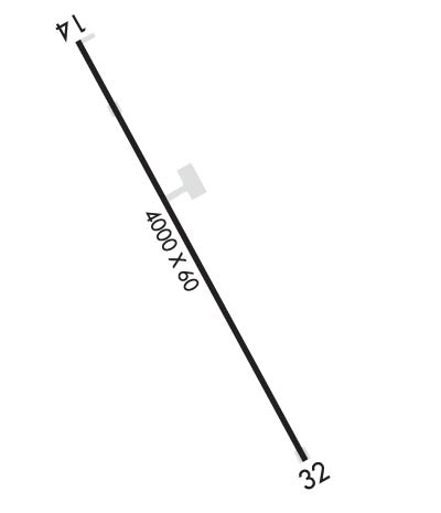
Runway Identifications
Runway Identification: 14/32
Length: 4000 ft
Width: 60 ft
Surface: ASPHALT-FAIR CONDITION
Edge lights: Low Intensity

Treatment: NONE

 Runway: 14   Runway: 32
Mag heading: 140°Mag heading: 320°
Rwy Slope: -.38% DownRwy Slope: .38% Up
Approach: Approach:
Pattern: Left TrafficPattern: Left Traffic
Markings: BASICMarkings: BASIC
Marking Condition: GOODMarking Condition: GOOD
Arresting Dev: Arresting Dev:
Lat & Long: N4351.4  W10043.0Lat. & Long.: N4350.8  W10042.5
Elev: 2270.1 ft. MSLElev: 2254.8 ft. MSL
TCH: TCH:
Visual Glide Path: Visual Glide Path:
Displaced Threshold: NoDisplaced Threshold: No
Touchdown Zone: YESTouchdown Zone: YES
Touchdown Elev.: 2270.1 feetTouchdown Elev.: 2263.2 feet
Visual Glide Slope: Visual Glide Slope:
RVR Equipment: RVR Equipment:
RVV Equipment: NORVV Equipment: NO
Approach Lights: Approach Lights:
REIL: NOREIL: NO
Centerline Lights: NOCenterline Lights: NO
Touchdown lights: NOTouchdown lights: NO
Runway Category: Runway with a Visual ApproachRunway Category: Runway with a Visual Approach
Declared Distances: Declared Distances:
Obstructions: Obstructions: FENCE
Marked: Marked: NOT Marked/Lighted
Clearance slope: 50:1Clearance slope: 23:1
Obstruction height: Obstruction height: 8 feet AGL
Dist. from runway: Dist. from runway: 390 feet
Centerline offset: Centerline offset:
Comments: Comments:
C:/P: