Click here for more info on on SMS!

K8F5

GREATER MORRIS COUNTY
DAINGERFIELD
TX
Time Zone: Central
Lat: N 3308.9
Long: W 09442.0
Elev: 402
Var: -05
Longest Runway: 3000
CTAF: 122.9

FBO & Flight Services info for K8F5

FBOs: Update your Fuel Prices

AIRPORT MANAGERPh: 903-645-3691
-
Freq: 122.9
Service
Jet
100LL
SAF
MoGas
Fuel Avail: NO FUEL AVAILABLE
Full        Last Update: 04/19/2024 00:01:46

Self        
If you are an FBO, call 1-203-262-1700 to update your info or email: FltPlan.Advertising@garmin.com
Advertise your FBO on FltPlan.com

Runway & Approach Info for K8F5
Rwy
Length
Land Dist**
Approach*
  Rwy
Length
Land Dist**
Approach*
17
3000x50  3000'          
 
  
35
  3000x50  3000'          
 
 * only ILS, LOC, LDA, and SDF approaches to a specific runway are shown
** For any Declared Landing Distance Available, please see A/FD or Approach plates
Runway Weight Capability (lbs.) Help
Runway IDSingle WheelDouble WheelDouble Tandem WheelDual Double Wheel
17/35N/AN/AN/AN/A
These numbers are Advisory and are not limits.   The Airport Manager should have more accurate Weight Limits
Approach Charts
FltPlan does not have IFR approach charts available for K8F5.
Current Weather/Notams
Customs Information Send updates to Support@FltPlan.com
Customs Not Available
Database effective 04/18/2024
Airport Diagram of K8F5
Airport Diagram might not be current.

Facility Name: GREATER MORRIS COUNTY
City Name: DAINGERFIELD
County: MORRIS
State abbrev: TX
State Name: TEXAS
   
Ownership: PUBLICLY OWNED
Use: OPEN TO THE PUBLIC
Owner's Name: COUNTY OF MORRIS
Address: 500 BROADNAX
 DAINGERFIELD, TX 75638
Owner's Phone: 903-645-3691
  
Manager's Name: GREGORY FRAZIER; COUNTY COMMISSIONER.
Address: 500 BROADNAX
 DAINGERFIELD, TX 75638
Phone: 903-445-1788
   
FAA Region: SOUTHWEST
FAA Field Office: TEX


Sunrise / Sunset times for GREATER MORRIS COUNTY

DateSunriseSunset
04/18/24 Thursday6:4419:52
04/19/24 Friday6:4319:53
04/20/24 Saturday6:4219:54
04/21/24 Sunday6:4119:54
04/22/24 Monday6:4019:55
04/23/24 Tuesday6:3919:56
04/24/24 Wednesday6:3819:57
04/25/24 Thursday6:3619:57
04/26/24 Friday6:3519:58
04/27/24 Saturday6:3419:59
04/28/24 Sunday6:3320:00
04/29/24 Monday6:3220:00
04/30/24 Tuesday6:3120:01
05/01/24 Wednesday6:3020:02

Airport Facilities

Airport Attendance ScheduleUNATTENDED
Airport Status OPERATIONAL (This Status can change at any time - please check NOTAMS)
Airport Lighting Schedule
Airport Storage AvailableNONE
Extra Services AvailableNONE
Wind IndicatorYES - (unlit)
Control TowerNO
CTAF Frequency122.900
Unicom Frequency
Rotating Beacon Color
Segmented CircleYES
Landing FeeNO

Airport Inspection Data

Airport InspectedCONTRACTOR - performed by PRIVATE CONTRACT PERSONNEL
Inspection Date09/13/2022

Airport Services

Type of Fuel AvailableNone
Airframe Repair ServiceNONE
Power Plant Repair ServiceNONE

Geographic Data

LatitudeN3308.9
LongitudeW09442.0 (ESTIMATED)
Arpt Elevation402ft (SURVEYED)
Magnetic Variation05E
7 miles Nof DAINGERFIELD
Traffic Pattern Altitude
Sectional ChartMEMPHIS

Aircraft Data

Operations (Reported)YearlyAvg. Daily
General Aviation Transient 500
General Aviation Local 00
Air Taxi 00
Commerical 00
Commuter 00
Military 00
Aircraft based on Field
General Aviation Singles 0
General Aviation Multi 0
Jet Aircraft 0
General Aviation Helicopters 0
Military Aircraft 0
Gliders 0
Ultralights 0

FAA Services

FSS on field NO
FSS tie-in FORT WORTH
FSS Phone 1-800-WX-BRIEF
Who issues Notams FTW
Notam D service at airport YES
ARTCC Name FORT WORTH

Federal Status

Airport Certification
Aircraft Rescue & Firefighting IndexNone
Airport of EntryNo
Custom Landing RightsNo
Joint Civil/MilitaryNo
Military Landing rightsYES

Federal Agreements

GRANT AGREEMENTS UNDER FAAP/ADAP/AIP
ASSURANCES PURSUANT TO TITLE VI, CIVIL RIGHTS ACT OF 1964

Remarks

NO LINE OF SIGHT BTN RWY ENDS.
NO BLDGS, NO FACS.
FOR CD CTC FORT WORTH ARTCC AT 817-858-7584.
NO AIRFRAME OR POWERPLANT RPRS AVBL.
RWY 17/3 5 EXTSV CRACKING, LOOSE GRVL & GRASS ON RWY & TWY. RWY CONDS NOT MNT.
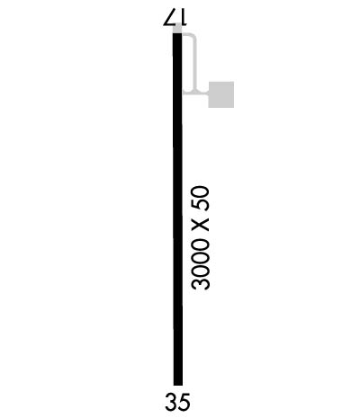
Runway Identifications
Runway Identification: 17/35
Length: 3000 ft
Width: 50 ft
Surface: ASPHALT-POOR CONDITION
Edge lights:

Treatment: NONE

 Runway: 17   Runway: 35
Mag heading: 175°Mag heading: 355°
Rwy Slope: .00%Rwy Slope: .00%
Approach: Approach:
Pattern: Left TrafficPattern: Left Traffic
Markings: BASICMarkings: NONE
Marking Condition: POOR; RWY MARKINGS FADED.Marking Condition: NO MARKINGS.
Arresting Dev: Arresting Dev:
Lat & Long: N3309.1  W09442.0Lat. & Long.: N3308.6  W09442.0
Elev: 402.0 ft. MSLElev: 402.0 ft. MSL
TCH: TCH:
Visual Glide Path: Visual Glide Path:
Displaced Threshold: NoDisplaced Threshold: No
Touchdown Zone: NOTouchdown Zone: NO
Touchdown Elev.: Touchdown Elev.:
Visual Glide Slope: Visual Glide Slope:
RVR Equipment: RVR Equipment:
RVV Equipment: NORVV Equipment: NO
Approach Lights: Approach Lights:
REIL: NOREIL: NO
Centerline Lights: NOCenterline Lights: NO
Touchdown lights: NOTouchdown lights: NO
Runway Category: Runway with a Visual ApproachRunway Category: Runway with a Visual Approach
Declared Distances: Declared Distances:
Obstructions: TREEObstructions: TREES
Marked: NOT Marked/LightedMarked: NOT Marked/Lighted
Clearance slope: 10:1Clearance slope: 5:1
Obstruction height: 36 feet AGLObstruction height: 42 feet AGL
Dist. from runway: 576 feetDist. from runway: 448 feet
Centerline offset: 150 left of centerlineCenterline offset: 150 feet right of centerline
Comments: Comments:
C:/P: