Click here for more info on on SMS!

K8F3

CROSBYTON MUNI
CROSBYTON
TX
Time Zone: Central
Lat: N 3337.4
Long: W 10114.5
Elev: 3018
Var: -08
Longest Runway: 3600
CTAF: 122.8

FBO & Flight Services info for K8F3

FBOs: Update your Fuel Prices

AIRPORTPh: 806-675-2301
-
Freq: 122.8
Service
Jet
100LL
SAF
MoGas
Fuel Avail: NO FUEL AVAILABLE
Full        Last Update: 04/24/2024 06:02:16

Self        
If you are an FBO, call 1-203-262-1700 to update your info or email: FltPlan.Advertising@garmin.com
Advertise your FBO on FltPlan.com

Runway & Approach Info for K8F3
Rwy
Length
Land Dist**
Approach*
  Rwy
Length
Land Dist**
Approach*
17
3600x60  3600'          
 
  
35
  3600x60  3600'          
 
 * only ILS, LOC, LDA, and SDF approaches to a specific runway are shown
** For any Declared Landing Distance Available, please see A/FD or Approach plates
Runway Weight Capability (lbs.) Help
Runway IDSingle WheelDouble WheelDouble Tandem WheelDual Double Wheel
17/3512,000N/AN/AN/A
These numbers are Advisory and are not limits.   The Airport Manager should have more accurate Weight Limits
Approach Charts
Approaches    
Current Weather/Notams
Customs Information Send updates to Support@FltPlan.com
Customs Not Available
Database effective 05/16/2024
Airport Diagram of K8F3
Airport Diagram might not be current.

Facility Name: CROSBYTON MUNI
City Name: CROSBYTON
County: CROSBY
State abbrev: TX
State Name: TEXAS
   
Ownership: PUBLICLY OWNED
Use: OPEN TO THE PUBLIC
Owner's Name: CITY OF CROSBYTON
Address: 221 W MAIN
 CROSBYTON, TX 79322
Owner's Phone: 806-675-2301
  
Manager's Name: AMY WALLACE; CITY/AIRPORT MGR.
Address: P.O. BOX 1187, 221 W MAIN
 RALLS, TX 79357
Phone: (806) 790-8533
   
FAA Region: SOUTHWEST
FAA Field Office: TEX


Sunrise / Sunset times for CROSBYTON MUNI

DateSunriseSunset
04/23/24 Tuesday7:0420:23
04/24/24 Wednesday7:0320:23
04/25/24 Thursday7:0220:24
04/26/24 Friday7:0120:25
04/27/24 Saturday7:0020:26
04/28/24 Sunday6:5920:26
04/29/24 Monday6:5820:27
04/30/24 Tuesday6:5720:28
05/01/24 Wednesday6:5620:29
05/02/24 Thursday6:5520:30
05/03/24 Friday6:5420:30
05/04/24 Saturday6:5320:31
05/05/24 Sunday6:5220:32
05/06/24 Monday6:5120:33

Airport Facilities

Airport Attendance ScheduleUNATTENDED
Airport Status OPERATIONAL (This Status can change at any time - please check NOTAMS)
Airport Lighting ScheduleACTVT MIRL RWY 17/35 - CTAF; OPR ON STEP 1 ONLY.
Airport Storage AvailableTie Downs
Extra Services AvailableCrop Dusting
Wind IndicatorYES - (lighted)
Control TowerNO
CTAF Frequency122.800
Unicom Frequency122.800
Rotating Beacon ColorWG
Segmented CircleYES
Landing FeeNO

Airport Inspection Data

Airport InspectedSTATE - performed by PRIVATE CONTRACT PERSONNEL
Inspection Date09/05/2021

Airport Services

Type of Fuel AvailableNone
Airframe Repair ServiceNone
Power Plant Repair ServiceNone

Geographic Data

LatitudeN3337.4
LongitudeW10114.5 (ESTIMATED)
Arpt Elevation3018ft (SURVEYED)
Magnetic Variation08E
2 miles Sof CROSBYTON
Traffic Pattern Altitude
Sectional ChartDALLAS-FT WORTH

Aircraft Data

Operations (Reported)YearlyAvg. Daily
General Aviation Transient 500
General Aviation Local 12003
Air Taxi 00
Commerical 00
Commuter 00
Military 00
Aircraft based on Field
General Aviation Singles 2
General Aviation Multi 0
Jet Aircraft 0
General Aviation Helicopters 0
Military Aircraft 0
Gliders 0
Ultralights 0

FAA Services

FSS on field NO
FSS tie-in FORT WORTH
FSS Phone 1-800-WX-BRIEF
Who issues Notams FTW
Notam D service at airport YES
ARTCC Name FORT WORTH

Federal Status

Airport Certification
Aircraft Rescue & Firefighting IndexNone
Airport of EntryNo
Custom Landing RightsNo
Joint Civil/MilitaryNo
Military Landing rightsYES

Federal Agreements

GRANT AGREEMENT HAS EXPIRED; HOWEVER, AGREEMENT REMAINS IN EFFECT FOR THIS FACILITY AS LONG AS IT IS PUBLIC USE.
ASSURANCES PURSUANT TO TITLE VI, CIVIL RIGHTS ACT OF 1964

Remarks

WINDSOCK LGT OTS INDEFLY.
FOR CD CTC FORT WORTH ARTCC AT 817-858-7584.
SEASONAL AERIAL AG ACTVTY.
Airport Communications & Frequencies:
CTAF Frequency:
122.800
Unicom Frequency:
122.800
LUBBOCK Primary Approach Frequencies:  
119.2
351.8
Part-time Approach Frequencies:  
119.9
335.6
LUBBOCK Primary Departure Frequencies:  
119.2
351.8
Part-time Departure Frequencies:  
119.9
335.6
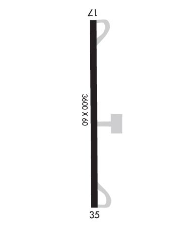
Runway Identifications
Runway Identification: 17/35
Length: 3600 ft
Width: 60 ft
Surface: ASPHALT-FAIR CONDITION
Edge lights: Medium Intensity

Treatment: NONE

 Runway: 17   Runway: 35
Mag heading: 172°Mag heading: 352°
Rwy Slope: -.15% DownRwy Slope: .15% Up
Approach: Approach:
Pattern: Left TrafficPattern: Left Traffic
Markings: BASICMarkings: BASIC
Marking Condition: POOR; RWY MARKINGS FADED.Marking Condition: POOR; RWY MARKINGS FADED.
Arresting Dev: Arresting Dev:
Lat & Long: N3337.7  W10114.5Lat. & Long.: N3337.1  W10114.5
Elev: 3018.0 ft. MSLElev: 3012.5 ft. MSL
TCH: TCH: 23 ft. AGL
Visual Glide Path: 4.00 degreesVisual Glide Path: 4.00 degrees
Displaced Threshold: NoDisplaced Threshold: No
Touchdown Zone: YESTouchdown Zone: YES
Touchdown Elev.: 3018.1 feetTouchdown Elev.: 3017.0 feet
Visual Glide Slope: 2-Box VASI on LEFT side of Runway; VASI OTS INDEFLY.Visual Glide Slope: 2-Box VASI on LEFT side of Runway; VASI OTS INDEFLY.
RVR Equipment: RVR Equipment:
RVV Equipment: NORVV Equipment: NO
Approach Lights: Approach Lights:
REIL: NOREIL: NO
Centerline Lights: NOCenterline Lights: NO
Touchdown lights: NOTouchdown lights: NO
Runway Category: Runway with a Non-precision ApproachRunway Category: Runway with a Non-precision Approach
Declared Distances: Declared Distances:
Obstructions: PLINEObstructions: TREES
Marked: LIGHTEDMarked: NOT Marked/Lighted
Clearance slope: 16:1Clearance slope: 14:1
Obstruction height: 38 feet AGLObstruction height: 15 feet AGL
Dist. from runway: 825 feetDist. from runway: 420 feet
Centerline offset: 275 right of centerlineCenterline offset: 210 feet right of centerline
Comments: 15 FT RD 165 FT DSTC ACRS APCH.Comments:
C:/P: