Current Weather/Notams (Metars, TAFs, Notams, NWS Forecast, PIREPS, and nearby weather)
Customs Information Send updates to Support@FltPlan.com
Customs Not Available
Database effective 04/18/2024
Airport Diagram might not be current.
|
| Facility Name: | MATHEWS MEML |
| City Name: | TIPTON |
| County: | CEDAR |
| State abbrev: | IA |
| State Name: | IOWA |
| | |
| Ownership: | PUBLICLY OWNED |
| Use: | OPEN TO THE PUBLIC |
| Owner's Name: | CITY OF TIPTON; BRIAN WAGNER - CITY ADMINISTRATOR. |
| Address: | 407 LYNN ST. |
| | TIPTON, IA 52772 |
| Owner's Phone: | 563-886-6187 |
| | |
| Manager's Name: | MAX COPPESS |
| Address: | 303 2ND AVENUE; EMAIL ADDRESS: MAXCOPPESS@AOL.COM (ALL LOWER CASE) |
| | STANWOOD, IA 52337 |
| Phone: | 563-212-3308; OR 563-886-6187 |
| | |
| FAA Region: | CENTRAL |
| FAA Field Office: | NONE |
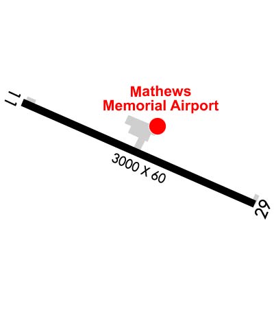
Runway Identifications
Runway Identification: 11/29Length: 3000 ft
Width: 60 ft
Surface: CONCRETE-FAIR CONDITION
Edge lights: Medium IntensityTreatment: NONE
Weight: PCN 6 /R/C/W/U
| | Runway: 11 | | Runway: 29 |
| Mag heading: | 108° | Mag heading: | 288° |
| Rwy Slope: | .00% | Rwy Slope: | .00% |
| Approach: | | Approach: | |
| Pattern: | Left Traffic | Pattern: | Left Traffic |
| Markings: | BASIC | Markings: | BASIC |
| Marking Condition: | FAIR | Marking Condition: | FAIR |
| Arresting Dev: | | Arresting Dev: | |
| Lat & Long: | N4145.9 W09109.5 | Lat. & Long.: | N4145.7 W09108.9 |
| Elev: | 840.0 ft. MSL | Elev: | 840.0 ft. MSL |
| TCH: | | TCH: | |
| Visual Glide Path: | | Visual Glide Path: | |
| Displaced Threshold: | No | Displaced Threshold: | No |
| Touchdown Zone: | YES | Touchdown Zone: | YES |
| Touchdown Elev.: | 840.0 feet | Touchdown Elev.: | 840.0 feet |
| Visual Glide Slope: | | Visual Glide Slope: | |
| RVR Equipment: | | RVR Equipment: | |
| RVV Equipment: | NO | RVV Equipment: | NO |
| Approach Lights: | | Approach Lights: | |
| REIL: | YES | REIL: | NO |
| Centerline Lights: | NO | Centerline Lights: | NO |
| Touchdown lights: | NO | Touchdown lights: | NO |
| Runway Category: | Runway with a Non-precision Approach | Runway Category: | Runway with a Visual Approach |
| Declared Distances: | | Declared Distances: | |
| Obstructions: | TREES | Obstructions: | ROAD |
| Marked: | NOT Marked/Lighted | Marked: | NOT Marked/Lighted |
| Clearance slope: | 40:1 | Clearance slope: | 12:1 |
| Obstruction height: | 70 feet AGL | Obstruction height: | 20 feet AGL |
| Dist. from runway: | 3042 feet | Dist. from runway: | 450 feet |
| Centerline offset: | 7 right of centerline | Centerline offset: | 150 feet right of centerline |
| Comments: | | Comments: | |