Current Weather/Notams (Metars, TAFs, Notams, NWS Forecast, PIREPS, and nearby weather)
Customs Information Send updates to Support@FltPlan.com
Customs Not Available
Database effective 04/18/2024
Airport Diagram might not be current.
|
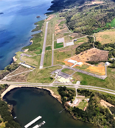
| Facility Name: | GUNTERSVILLE MUNI/JOE STARNES FLD |
| City Name: | GUNTERSVILLE |
| County: | MARSHALL |
| State abbrev: | AL |
| State Name: | ALABAMA |
| | |
| Ownership: | PUBLICLY OWNED |
| Use: | OPEN TO THE PUBLIC |
| Owner's Name: | CITY OF GUNTERSVILLE |
| Address: | 341 GUNTER AVE |
| | GUNTERSVILLE, AL 35976 |
| Owner's Phone: | 256-571-7560 |
| | |
| Manager's Name: | GARY MCILQUHAM |
| Address: | 405 BUCK ISLAND RD |
| | GUNTERSVILLE, AL 35976 |
| Phone: | (256) 582-6087 |
| | |
| FAA Region: | SOUTHERN |
| FAA Field Office: | JAN |
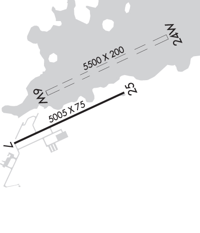
Runway Identifications
Runway Identification: 06W/24WLength: 5500 ft
Width: 200 ft
Surface: WATER
Edge lights: Treatment: NONE
| | Runway: 06W | | Runway: 24W |
| Mag heading: | 69° | Mag heading: | 249° |
| Rwy Slope: | .00% | Rwy Slope: | .00% |
| Approach: | | Approach: | |
| Pattern: | Left Traffic | Pattern: | Left Traffic |
| Markings: | | Markings: | |
| Marking Condition: | | Marking Condition: | |
| Arresting Dev: | | Arresting Dev: | |
| Lat & Long: | N3424.4 W08616.0 | Lat. & Long.: | N3424.7 W08615.0 |
| Elev: | 595.0 ft. MSL | Elev: | 595.0 ft. MSL |
| TCH: | | TCH: | |
| Visual Glide Path: | | Visual Glide Path: | |
| Displaced Threshold: | No | Displaced Threshold: | No |
| Touchdown Zone: | YES | Touchdown Zone: | YES |
| Touchdown Elev.: | 595.0 feet | Touchdown Elev.: | 595.0 feet |
| Visual Glide Slope: | | Visual Glide Slope: | |
| RVR Equipment: | | RVR Equipment: | |
| RVV Equipment: | NO | RVV Equipment: | NO |
| Approach Lights: | | Approach Lights: | |
| REIL: | NO | REIL: | NO |
| Centerline Lights: | NO | Centerline Lights: | NO |
| Touchdown lights: | NO | Touchdown lights: | NO |
| Runway Category: | | Runway Category: | |
| Declared Distances: | | Declared Distances: | |
Runway Identification: 07/25Length: 5005 ft
Width: 75 ft
Surface: ASPHALT-GOOD CONDITION
Edge lights: Medium IntensityTreatment: GROOVED
| | Runway: 07 | | Runway: 25 |
| Mag heading: | 69° | Mag heading: | 249° |
| Rwy Slope: | .09% Up | Rwy Slope: | -.09% Down |
| Approach: | | Approach: | |
| Pattern: | Left Traffic | Pattern: | Left Traffic |
| Markings: | NONPRECISION INSTRUMENT | Markings: | NONPRECISION INSTRUMENT |
| Marking Condition: | FAIR | Marking Condition: | FAIR |
| Arresting Dev: | | Arresting Dev: | |
| Lat & Long: | N3424.0 W08616.3 | Lat. & Long.: | N3424.4 W08615.4 |
| Elev: | 610.0 ft. MSL | Elev: | 614.6 ft. MSL |
| TCH: | | TCH: | 50 ft. AGL |
| Visual Glide Path: | | Visual Glide Path: | 3.35 degrees |
| Displaced Threshold: | No | Displaced Threshold: | No |
| Touchdown Zone: | YES | Touchdown Zone: | YES |
| Touchdown Elev.: | 610.1 feet | Touchdown Elev.: | 614.6 feet |
| Visual Glide Slope: | | Visual Glide Slope: | 2-Light PAPI on LEFT side of Runway |
| RVR Equipment: | | RVR Equipment: | |
| RVV Equipment: | NO | RVV Equipment: | NO |
| Approach Lights: | | Approach Lights: | |
| REIL: | YES | REIL: | YES |
| Centerline Lights: | NO | Centerline Lights: | NO |
| Touchdown lights: | NO | Touchdown lights: | NO |
| Runway Category: | Runway with a Non-precision Approach having visibility minimums greater than 3/4 mile | Runway Category: | Runway with a Non-precision Approach having visibility minimums greater than 3/4 mile |
| Declared Distances: | | Declared Distances: | |
| Obstructions: | TREE | Obstructions: | TREES |
| Marked: | NOT Marked/Lighted | Marked: | NOT Marked/Lighted |
| Clearance slope: | 8:1 | Clearance slope: | 1:1 |
| Obstruction height: | 45 feet AGL | Obstruction height: | 19 feet AGL |
| Dist. from runway: | 604 feet | Dist. from runway: | 233 feet |
| Centerline offset: | 297 right of centerline | Centerline offset: | 142 feet right of centerline |
| Comments: | | Comments: | |